It's not your imagination.Is it my imagination or has that area north of Panama produced a disproportionate amount of storms this season?
You are using an out of date browser. It may not display this or other websites correctly.
You should upgrade or use an alternative browser.
You should upgrade or use an alternative browser.
Heads up
- Thread starter ggunn
- Start date
Please register or login
Welcome to ScubaBoard, the world's largest scuba diving community. Registration is not required to read the forums, but we encourage you to join. Joining has its benefits and enables you to participate in the discussions.
Benefits of registering include
- Ability to post and comment on topics and discussions.
- A Free photo gallery to share your dive photos with the world.
- You can make this box go away
gopbroek
Contributor
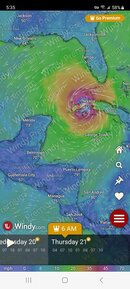
Way to early to get an accurate prediction but if you go to Windy and run their 10 day graphical animation it shows the system forming above roatan and slobbering around building strength then mid next week tracking NNW between Cozumel and Cuba. Then it models to hit a blocking system and then at full strength sliding east along Cuba, the 10 day model ends with it stalled over Havana.
Way to early to trust but if it holds it does not look good for Cozumel diving starting this weekend.

It has turned red and 80% on the 7 day prediction on the NHC website this morning.Way too early to get an accurate prediction..
- Messages
- 54,470
- Reaction score
- 8,575
- # of dives
- 500 - 999
Now at 90% probability on the 7 day outlook...

Here's what Windfinder looks like for early Tuesday morning. Windguru showing waves 7.7' Monday.

- Messages
- 54,470
- Reaction score
- 8,575
- # of dives
- 500 - 999
20 feet Monday night, 25 by 3am Tuesday...Windguru showing waves 7.7' Monday.
gopbroek
Contributor
Current windguru in kph (It is Mexico, port captain uses KPH and direction for closures.

Path keeps shifting which is probably why NOOA hasn't put a prediction out.
Current Windy animation

Path keeps shifting which is probably why NOOA hasn't put a prediction out.
Current Windy animation
I'm now seeing max 3.1m or just under 10' on Windguru.

The NHC just issued a projected path that shows Nineteen reaching the Yucatan near the Belize border on Monday as a TS. It will likely get a name by tomorrow.I'm now seeing max 3.1m or just under 10' on Windguru.


