Keep an eye on this one

Please register or login

Welcome to ScubaBoard, the world's largest scuba diving community. Registration is not required to read the forums, but we encourage you to join. Joining has its benefits and enables you to participate in the discussions.

Benefits of registering include

  • Ability to post and comment on topics and discussions.
  • A Free photo gallery to share your dive photos with the world.
  • You can make this box go away

Joining is quick and easy. Log in or Register now!

See what I mean - models are changing again! One model last night brought it right over us, and now just to the north of us - no certainty yet, still too early - but we are watching it! In the meantime, let's go diving!
View attachment 131473

Good point Christi. It's important to note...the strongest part of a tropical storm and where the worst conditions are found is the north-eastern quadrant. So if Ernesto tracks just a little to the north of Cozumel, the worst effects of the storm will occur well away from the island. You might be diving as the storm passes ;)
 
Good point Christi. It's important to note...the strongest part of a tropical storm and where the worst conditions are found is the north-eastern quadrant. So if Ernesto tracks just a little to the north of Cozumel, the worst effects of the storm will occur well away from the island. You might be diving as the storm passes ;)

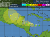
You are correct, on the below enlargement the outside circle is the "potential track area" and the inside quadrants (triangles) are the "wind radius". So as you mentioned and as you can see, the NE is the strongest and he SW is the weakest.

Larger view.. Click Here

storm-10.jpg
 
It looks ominous on that big map! The projected wind velocity during the time it crosses the Yucatan peninsula is 90 mph. While that seems terrible to most people, it's what those of us who live in the "hurricane zone" consider a nuisance.

The slightest change in the current track can make a huge difference in where it ends up by the time it reaches the Yucatan. Let's just hope the track adjusts slightly to the north and then it won't be a problem for Cozumel. But then it will probably end up coming to visit us up here in Louisiana :shocked2:
 
Here is the latest forecast from the WeatherUnderground web site.. (copied & pasted).

Posted by: Dr. Jeff Masters, 4:12 PM GMT on August 04, 2012

Enigmatic Tropical Storm Ernesto continues westward across the Caribbean, but has weakened. Ernesto certainly looks impressive on visible satellite loops, with a symmetric shape, good spiral banding, and an upper-level outflow channel to the north and east. But this morning's flight by the Hurricane Hunters found that Ernesto had weakened, with top winds of just 50 mph, and a central pressure that had risen to 1008 mb. The storm is fighting low to moderate wind shear of 5 - 15 knots, and water vapor satellite loops show a large area of dry air to the west. Upper level winds from the west are driving this dry air into the west side of the storm. Ernesto's rains are staying just north of the ABC Islands, as seen on Aruba radar. The southern shore of the Dominican Republic is experiencing occasional heavy rains from Ernesto's spiral bands.

Forecast for Ernesto
Ernesto continues to be a major challenge to forecast. Despite the seemingly favorable conditions for intensification expected today through Tuesday, with low wind shear, a moister environment, and increasing heat energy in the ocean, many of our top computer models refuse to predict intensification, and in fact, weaken the storm. Of the major dynamical models NHC uses operationally--the ECMWF, GFS, NOGAPS, UKMET, GFDL, and HWRF--only the NOGAPS and GFDL show Ernesto reaching hurricane strength in the Caribbean. The ECMWF dissipates the storm. However, some of the best statistical models, such as the LGEM and SHIPS, do show Ernesto becoming a Category 1 or 2 hurricane in the Caribbean. The official NHC intensity forecast of a Category 1 hurricane between Jamaica and Mexico's Yucatan Peninsula is a reasonable compromise, but the uncertainty in this is high. It would not be a surprise to see Ernesto mysteriously degrade, or undergo rapid intensification into a Category 2 hurricane off the coast of the Yucatan. Such is the state of modern hurricane intensity forecasting. Given that we don't have a very good idea of how strong Ernesto will become, making an accurate track forecast is hard. A stronger Ernesto will be more likely to feel the influence of a trough of low pressure moving to the north of the storm on Tuesday, which would pull the storm to the northwest into the Gulf of Mexico. This would likely result in a landfall in the U.S. A weaker Ernesto is more likely to head almost due west, resulting in a landfall Wednesday in Belize or Mexico's Yucatan Peninsula. This is the more likely solution, given the recent behavior of the storm.
 
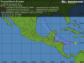
The forecast looks a lot better this morning from a Cozumel-centric point of view. It has the center of the storm hitting the Yucatan in northern Belize.
 
It looks ominous on that big map! The projected wind velocity during the time it crosses the Yucatan peninsula is 90 mph. While that seems terrible to most people, it's what those of us who live in the "hurricane zone" consider a nuisance.

EXACTLY! That's what I've been saying - this is going to be a nuisance, nothing more - and now looks like we may not even get any abnormal rain - just maybe a day or two of rain and possible thunderstorms

Chief, yep - November 18 sounds about right when we were able to get back to diving after Wilma, for those who had any customers. Like I said, my first ones arrived the Saturday before Thanksgiving. I've read her blog, I still can't believe she went through that monster alone - I cannot imagine! I had stranded tourists in my house who were not experienced with hurricanes - but they were GREAT and we all worked together before, during and after the storm. Naturally, we concreted some pretty deep bonds going through that together.

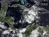
Sorry for those south of us - they will get alot more rain and have a nuisance on their hands! Good news for them is that it's not even predicted to hit as a Cat 1 anymore, just a TS. The satellite image doesn't even look that ominous compared to most storms. This looks like a band of thunderstorms more than an organized storm.

at201205_5day.gif

at201205_model.gif

at201205_sat.jpg
 
Last edited:
Tropical Storm = a blowout with flooding, but not for Cozumel.
 
So I lost a bet.. I am usually pretty good at this.. my buddy in Belize said it would track like previous or a little south and I countered with no, I think it will pull to the east and track thread the needle of cuba and get absorbed by the low that seems to be trying to dissipate now over the Bahamas. lol... so begins my yearly friendly argument with my other weather junkies on where these guys will go. I would much prefer they never form, or if they do they are only a threat to shipping. I am down a sixer of bootleg mexican beer it seems. I was up a couple bottles of sangria at the end of last yr...
May all of you have fair winds and great viz on your dives.
'bella
st pete
chetumal
 
What Christi said! Way too early to be worried; just watch the weather whether there is one or not. Yes, it will be Ernesto by Thursday and is expected to make Cat-1, but who knows where it will go.

I hope you already have Trip Insurance tho.

This map should auto update, but it'll be a week before we know how close it will get...

at201205_5day.gif

You never know about these storms---ask me about Rita, the 'unnamed' storm, see below(most people heard about Katrina, but not Rita---she kicked us a new butthole here in SW La)...Being around them since 1958---Hurricane Audrey-- I can tell you you'll know where she/he's heading when they 'touchdown'.....Good luck to whomever 'gets him'.......


Rita--@ 8AM local time on a Thursday, I left for work with Rita heading 'into Houston'. Got home @ about 11:30 AM that same day & the wife was watching the latest prediction of her---now heading straight up our gonads..& yes, the next day, Friday, she made landfall @ about 4 PM..Us being ~80 miles inland 'got it' by 10 PM Friday nite...It 'stayed' around till about 6 AM Saturday......We had sustained winds registered @ our airport(about 1 mile from our house) of 90 MPH with gusts to 120---& something like over 150 tornadoes were spawned off of it.....

---------- Post Merged at 10:47 AM ---------- Previous Post was at 10:46 AM ----------

You are correct, on the below enlargement the outside circle is the "potential track area" and the inside quadrants (triangles) are the "wind radius". So as you mentioned and as you can see, the NE is the strongest and he SW is the weakest.

Larger view.. Click Here

storm-10.jpg
That NE quadrant is NOT what you want---to get,....SW is ~ 5 times better.....

---------- Post Merged at 10:49 AM ---------- Previous Post was at 10:46 AM ----------

The forecast looks a lot better this morning from a Cozumel-centric point of view. It has the center of the storm hitting the Yucatan in northern Belize.


Again I'll say, watch out for the NE quadrant........MUCH worse....
 
So I lost a bet.. I am usually pretty good at this..
It fooled Dr.Master repeatedly, and he's the best to many of us...
 

Back
Top Bottom