Keep an eye on this one

Please register or login

Welcome to ScubaBoard, the world's largest scuba diving community. Registration is not required to read the forums, but we encourage you to join. Joining has its benefits and enables you to participate in the discussions.

Benefits of registering include

  • Ability to post and comment on topics and discussions.
  • A Free photo gallery to share your dive photos with the world.
  • You can make this box go away

Joining is quick and easy. Log in or Register now!

Chris, that is still 100 miles south! Still a non-event!

Latest update says it will make landfall about midnight, which makes sense since the center is currently DIRECTLY south of the island by about 100 - 120 miles. You can also see that the center of the storm is already approaching land.
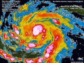
376193_10151033005367739_294063599_n.jpg

Current conditions on the island at 7:40pm with the storm in the above location: light winds (trees and treetops along my street are barely moving) and not raining.

Here is Jeff Masters update: Dr. Jeff Masters' WunderBlog : Ernesto reaches hurricane strength as it approaches the Yucatan | Weather Underground

Forecast for Ernesto
Ernesto will continue to track west this afternoon and evening, making landfall north of the Belize/Mexico border around midnight tonight. Given the current state of the hurricane, some more intensification is possible over the next few hours as it approaches land. Heavy rains continue to be the main threat from Hurricane Ernesto. The Hurricane Center is forecasting 4 to 8 inches of rain to fall, increasing in the higher elevation of Belize. After landfall, the storm will take about a day to cross the Yucatan, and the terrain will diminish its winds. Once Ernesto re-emerges over water into the Bay of Campeche in the southern Gulf of Mexico, wind shear will be light and ocean waters warm with high heat content. Ernesto is then expected to redevelop some strength and potentially regain hurricane status while over water, which a few of the models are suggesting. Second landfall will probably occur Friday morning around Veracruz, Mexico, but could reach land anywhere from Tuxapan to Coatzacoalcos.
 
Last edited:
Not to be argumentative cause I'm up here and you're down there but the latest map I've seen shows the center of the storm (12 hours out) passing right over top of Felipe Carrillo Puerto. How far south is that ?
Google Maps Directions says 159 KM = 98 miles. The computer models seem to agree on landing south of the Sian Ka'an Reserve, more than halfway from Playa del Carmen to Chetumal - subject to change. (corrected, as it is expected closer to Chetumal)
 
pretty far south... It is closer to Chetumal than it is Coz. We are 5 or 6 hrs south of Playa ? I think...

edited Wed : looks like it wobbled to the NE a bit and went onshore at Mahahual.

Not to be argumentative cause I'm up here and you're down there but the latest map I've seen shows the center of the storm (12 hours out) passing right over top of Felipe Carrillo Puerto. How far south is that ? The distance between the storm points on the map is 12 hours so they're talking hitting the mainland about 3 am..ish.

Hope it passes as far south as possible.

Click for Larger view

storm-14.jpg
 
Last edited:
Are you in Chetumal Magnolia? What are the current conditions there?

---------- Post Merged at 07:54 PM ---------- Previous Post was at 07:52 PM ----------

Google Maps Directions says 159 KM = 98 miles. The computer models seem to agree on landing south of the Sian Ka'an Reserve, more than halfway from Playa del Carmen to Chetumal - subject to change. (corrected, as it is expected closer to Chetumal)

Yes, that's just south of Tulum -

I would be interested to have a first hand report of how the conditions are south of here. I hope all of our neighbors to the south stay dry and safe.
 
Thanks all for the replies. Hope everyone is safe wherever it hits land.

Hopefully in 48 hours it will be gone with little damage in its wake. See you Saturday !!!
 
Thanks all for the replies. Hope everyone is safe wherever it hits land.

Hopefully in 48 hours it will be gone with little damage in its wake. See you Saturday !!!

Have a great trip and enjoy the diving...you'll never know there was a storm anywhere around :D
 
As of 8:26 PM, Tuesday evening, I am at this very moment looking at moving clouds and stars in the sky of Cozumel. No rain, light gusts of wind and cool temperature. Two dives in today. Palancar Horseshoe and Punta Tunich. Light current. Good vis. Nurse shark count 7, which included a pair in tandem. Two seahorse , two green moray and PLENTY of fish out and about. Overall, a VERY good day !!!!!
 
Last edited:
Horseshoe was one of my favorites last week, and Tunich always is! Look forward to hearing about the rest of your trip, I'm having terrible withdraw, tropical storm or hurricane be darned....
As of 8:26 PM, Tuesday evening, I am at this very moment looking at moving clouds and stars in the sky. No rain, light gusts of wind and cool temperature. Two dives in today. Palancar Horseshoe and Punta Tunich. Light current. Good vis. Nurse shark count 7, which included a pair in tandem. Two seahorse , two green moray and PLENTY of fish out and about. Overall, a VERY good day !!!!!
 
Storm is moving ashore now. Here is a great little clip from the Weather Channel! Center should be hitting Chetumal in the next hour to hour and a half - and still calm here!

Ernesto Heading Inland - weather.com
 
Storm is moving ashore now. Here is a great little clip from the Weather Channel! Center should be hitting Chetumal in the next hour to hour and a half - and still calm here!

Ernesto Heading Inland - weather.com

It is a bit north of us... My other half is there.. talking on skype right now...

FB page for these guys they are posting real time photos.. Yes, Christi I know its Yucatan STATE, however the civil proteccion for Quintana Roo is pretty crappy. These guys are rocking tonight..
Protección Civil Yucatán | Facebook

http://ibiseye.com/

Belize weather service.. pertinent radar image on home page
http://www.hydromet.gov.bz/
under the radar pic, click 400Km to enlarge photo

Its 9:28pm in Chet... wind is picking up.. looks like it will make landfall in the next few hours.. we are going to be on the west side of this thing.. shrug... by the morning it will be blue skys for everyone..
 
Last edited:

Back
Top Bottom