Gustav

Please register or login

Welcome to ScubaBoard, the world's largest scuba diving community. Registration is not required to read the forums, but we encourage you to join. Joining has its benefits and enables you to participate in the discussions.

Benefits of registering include

  • Ability to post and comment on topics and discussions.
  • A Free photo gallery to share your dive photos with the world.
  • You can make this box go away

Joining is quick and easy. Log in or Register now!

This morning's models indicate that Cozumelenos should keep an eye on Hanna as well.
Some distance out, but half of the models do show her coming thru the T&C/Bahamas for possible hits on Cuba, Jamaica, Caymans - then once in the neighborhood...?

Historically, storms where she now is generally go up the US east coast. Odd that this one was pushed toward the Caribbean.
 

Attachments

  • hanna.gif
    hanna.gif
    33.2 KB · Views: 64
  • hanna 2.gif
    hanna 2.gif
    34.2 KB · Views: 73
  • hanna 3.gif
    hanna 3.gif
    29.4 KB · Views: 53
Some distance out, but half of the models do show her coming thru the T&C/Bahamas for possible hits on Cuba, Jamaica, Caymans - then once in the neighborhood...?

Historically, storms where she now is generally go up the US east coast. Odd that this one was pushed toward the Caribbean.

There is something in the modeling that is affecting both storms; Gustav's projected path is drifting to the left as well. A couple of days ago it was pointed directly at my sister in Slidell, and now it's headed for my mom in Lake Charles.
 
There is something in the modeling that is affecting both storms; Gustav's projected path is drifting to the left as well. A couple of days ago it was pointed directly at my sister in Slidell, and now it's headed for my mom in Lake Charles.
The High currently on Louisiana and it's front I suppose.
 

Attachments

  • curwx_600x405.jpg
    curwx_600x405.jpg
    36.6 KB · Views: 37
Good luck down there. This story sounds a lot like 3 yrs ago in October when I was there as Wilma approached.

No...Wilma came out of nowhere...literally! Remember that she wasn't even a tropical depression and became a tropical depression in the Caribbean...and then overnight became a Cat 5 moving fast.

Gustav is a baby and we're now completely out of the uncertainty cone as stated in the latest advisory:

Gustav's impact on Cuba and Mexico's Cancun/Cozumel region

Cancun and Cozumel are no longer in the cone of uncertainty, so a direct hit from Gustav is unlikely. Remember, though, that the cone is only right about 2/3 of the time--historically, over the past five years, about 1/3 of storm positions have fallen outside the cone. For example, the NHC forecasts issued at 5 pm, 8pm and 11pm Wednesday all put the cone of uncertainty along the northern portion of Jamaica, and the eventual track of Gustav directly over the island fell outside the cone of uncertainty. With that caveat in mind, those of you planning to visit Cancun/Cozumel will probably only have one day of heavy rain (Saturday), with some wind gusts of 40-50 mph. The Yucatan will be on the weak (left) side of Gustav, where tropical storm force winds do not extend out as far. The odds of Cozumel getting sustained winds of tropical storm force (39 mph or greater) have decreased to 23%, as indicated in NHC's wind probability product. The odds of hurricane force winds are 3%.

Gordon and Don...no offense intended at all, and with respect I request that we not create worry and panic before it's necessary. There is nothing in the models that indicate that Hanna is a threat to us...her predicted landfall in the Bahamas is still almost a week out...so literally anything can happen after that. There is no way that storm's path can be predicted further out...so can we at least wait until it reaches the Caribbean before we start with the doom and gloom? Pretty please? :)
 
Gordon and Don...no offense intended at all, and with respect I request that we not create worry and panic before it's necessary. There is nothing in the models that indicate that Hanna is a threat to us...her predicted landfall in the Bahamas is still almost a week out...so literally anything can happen after that. There is no way that storm's path can be predicted further out...so can we at least wait until it reaches the Caribbean before we start with the doom and gloom? Pretty please? :)

I agree!! I do not want gloom on Vacation next week!!!!
 
Subject to change until the event is over as always, prospects do look better now, and yes - Hanna is a but a distant suggestion. Only 2 of the 6 models show a Louisiana hit now even tho the cone is still focused there...
 

Attachments

  • Gus.gif
    Gus.gif
    47.2 KB · Views: 46
  • Gus 2.gif
    Gus 2.gif
    43.7 KB · Views: 53
  • Gus 3.gif
    Gus 3.gif
    49.3 KB · Views: 38
  • Screen02_edited.JPG
    Screen02_edited.JPG
    94.7 KB · Views: 42
Gordon and Don...no offense intended at all, and with respect I request that we not create worry and panic before it's necessary. There is nothing in the models that indicate that Hanna is a threat to us...her predicted landfall in the Bahamas is still almost a week out...so literally anything can happen after that. There is no way that storm's path can be predicted further out...so can we at least wait until it reaches the Caribbean before we start with the doom and gloom? Pretty please? :)

None taken, but who said anything doomy or gloomy? Keep an eye on it is all I said, and we're doing that, aren't we? But OK, mum's the word.
 
Gordon and Don...no offense intended at all, and with respect I request that we not create worry and panic before it's necessary. There is nothing in the models that indicate that Hanna is a threat to us...her predicted landfall in the Bahamas is still almost a week out...so literally anything can happen after that. There is no way that storm's path can be predicted further out...so can we at least wait until it reaches the Caribbean before we start with the doom and gloom? Pretty please? :)

Boy do I hope your right about that!!!
Peggy and I are leaving for Freeport tomorrow....
 
Gordon and Don...no offense intended at all, and with respect I request that we not create worry and panic before it's necessary. There is nothing in the models that indicate that Hanna is a threat to us...her predicted landfall in the Bahamas is still almost a week out...so literally anything can happen after that. There is no way that storm's path can be predicted further out...so can we at least wait until it reaches the Caribbean before we start with the doom and gloom? Pretty please? :)

Here you go:

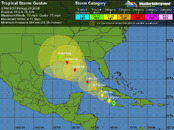
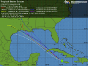
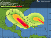
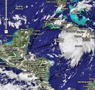
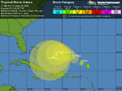
The forecast for Hanna
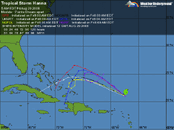
Steering currents imparted by the counterclockwise flow around the upper-level low to its west will keep Hanna moving northwest, to a point midway between Bermuda and the Bahama Islands. About 3-4 days from now, a strong blocking ridge of high pressure is forecast by most of the models to build over Hanna, forcing it to the southwest towards the Bahamas. This is an unusual motion for a hurricane, and it would be surprise to see Hanna move as far south as some of the models are predicting--all the way into Cuba. However, the Bahamas are at high risk from this storm 4-5 days from now. Hanna may be weakening at that time, as wind shear from an upper-level trough to the north of the storm is expected to bring 15-25 knots of shear to the storm. In the longer term, both the ECMWF and GFS models are predicting Hanna will pass through South Florida or the Florida Keys into the Gulf of Mexico by Thursday or Friday next week.

A major complicating factor in forecasting both Hanna's track and intensity may be the possible development of a tropical disturbance behind it, near 18N 41W (see discussion below, under "Elsewhere in the tropics". This disturbance is forecast to develop into a tropical storm 3-5 days from now by some of the models. If so, the new storm could substantially alter the path and strength of Hanna. Don't believe that Hanna will be going through South Florida quite yet; the models do very poorly with hurricane-hurricane interactions, and the long term fate of Hanna is still highly uncertain.

So Jeff Masters is skeptical of the models that push it into Cuba. Much less zipping through Cuba, reforming and hitting Cozumel.

...

The most worrisome disturbances to Cozumel right now is probably 97L coming off of Africa and two other tropical waves lined up behind it. Those are >> 1 week out, though, and no idea if they'll develop or if they'll curve off. Africa could pitch a fastball through the lesser antillies, though (which I believe was the track that Dean took?).
 

Back
Top Bottom