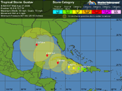
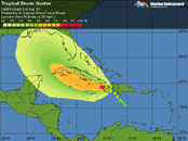
My advise is to watch closely, but don't make your travel decisions until Friday. On the current track, the storm will still be quite a way out from us on Friday afternoon/Saturday morning. The airlines will make decisions about that time...and if you cancel prematurely (before the airlines do) then you will face normal flight cancellation penalties, etc. You have nothing to lose really by waiting until the last minute to cancel, and more to lose if you cancel prematurely and then we are unaffected as the models are now showing and are more in agreement.
If it says on current track, we might have some rain, but even then, we are on the southeast side of the storm (the "clean/dry" side) and WELL outside of the hurricanes/TS wind range. This is a small storm and the winds are only extending out 50 miles from the eye.
As far as visibility, with all due respect...that really should be the least of our concerns when watching a storm...but in the worst case vis for Cozumel is about 60ft.
I am watching this storm, but I am optimistic that the current track will hold and we'll be fine here. The next 24 to 48 hours will give us a much better picture.