Sunfish Pond report. Sunday July 03, 2016.
It is getting real. I recently got all the basic gear to do this survey properly, was dying to get at it. Called REI on Saturday and told them I was bringing everything up to be fitted to a backpack. No prob! When your get here ask for xxx. Great fun, got the first relatively inexpensive backpack that I ever loved. Dude custom fitted strap to me and my load. Kudos, guys! Somebody will ask, it is a Deuter. Act Lite G5+10. Totally German. Made in Viet Nam. (my dear friend My Linh likes that part a lot)
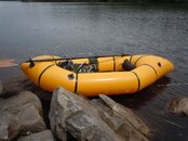
Filled the backpack with a serious packraft, paddles, a Type III Adult XL PFD (flotation vest), lunch, four bottles of water, my electronics, line and heavy plumb bob, and all the other neat campy necessities. 22 Pounds fully loaded! This could work! I didn’t even need to deploy the expandable skirt that is there for lots and lots of stuff.
Off to the pond, get to the trailhead. HUGE Problem!!! All parking closed, park is at capacity. Every blessed trailhead had a ranger and cones, “keep moving”. Drove under I-80 to where a bunch of rangers were talking. Nearest parking is eight miles away on the PA side. OMG. One particularly nice ranger comes over and says to try the “three minute light” before you give up. Oh! That is how BRD goes… Funky two-lane road that comes to an odd traffic light. The lights control the single lane portion of this road. Neat little road, never thought that you could cement a road to the side of a cliff… I get there, parked full up. Oh, yeah. Fourth of July weekend. But wait! Somebody pulls out!!! Bless you whoever you are!!!
Don’t know exactly where I am but at least I’m in the right state! Call Basking Ridge Diver. Made his day, I was right across the street from where I wanted to be. :sigh: Let’s do this!
I see his point with respect to favoring this particular trail, get the elevation over with while you are fresh. Seems to be a shorter access too. You also hit the Appalachian trail fairly soon on this access. Back in familiar territory. Lovely walk, feeling good. Get to the pond, never saw so many people there, probably eight groups of four or five people. The trail past the pond is fairly rocky and has a lot of brush blocking water access. Was eyeing a really nice launch point but filled with people. Lovely woman waves at me and says that they are getting ready to leave if I wanted to camp here. No, but this is one of the few really good spots for setting up and launching a boat. Would you mind? “No! We would love watching!” Really cool people. We swap stories while I blow up a raft. They have to go, getting into late afternoon and this is a new moon. If you goof up you walk back in total darkness. Crap, didn’t even think to check…
Game on!
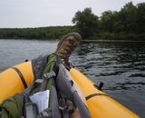
Tough ass little raft. Got into it on the submerged rocks and dragged it free, try that with a vinyl inflatable. Not even a wimper and we are off.
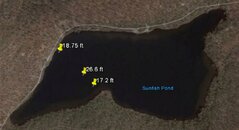
Wow! Immediately looks deep. I brought a roll of Dyneema line and a plumb bob. Drops like a rock to almost nineteen feet! Wow, just offshore! Shelf??? Maybe there is something to this… Buzzkill. Take a reading in the middle, around 26 feet. Burst my bubble, odd, that’s nowhere near 600’.

Today was not the beginning of the actual survey, it was intended to be a “lessons learned” trip. And indeed there were a multitude of lessons to be learned.
Lessons learned;
A packraft floats like a leaf on the water, high profile and very stable. Problem: wind blows you wherever it wishes. Simultaneously finding a grid point by watching the coordinates change, holding position, and measuring depth is just no fun. Need to change this. Looking into entering all grid points into GPS via Garmin’s Basecamp software. Then it becomes more like geocaching. I’ll try that next time and maybe with a fisherman’s bottom finder.
The inflatable seat and backrest make the raft stupidly comfortable. Couldn’t help scooching down and getting comfy. No! that long drift had nothing to do with me dozing off. Ermm. Back to it. Not much room to work, though. See pic with my size twelve pointing at the tree on the promontory that can be seen from space (Google Earth). Pile of wet line in Ballantine loops in my lap. I learned that from a brief stint with the Kalmar Nyckel. Line runs clean and won’t ever tangle.
I really need to come up with a workspace for this raft. Dropping everything back into the backpack on each use means that you just have to search for everything every time you need it (while you are drifting).
Everything gets wet. Deal with it. Yes, you can paddle so carefully that the paddle rings block the water, but not in wind. Going to a grease pencil based something and just accept it. Water is good.
Depth sounding. Works great, but not while the wind is blowing you around. The bottom that I sounded is covered by a thick mat of vegetation. Pulled a lot of it up. Not going to risk a dive computer on that, especially while being dragged by the wind. Looking at fish finders/bottom finders right now. Suggestions anybody?
Even more so dying to properly profile this pond. Why a ledge on either side? Isn’t this supposed to be a glacial scour? I would have expected a gradual bowl shape. What about the other end? I’m guessing deeper. This gets interesting from a geological perspective.
Viz is OK, but not great, judging by my depth sounding line. 10-15’ Maybe?
Plan:
Do a decent surface survey, maybe drop GoPro’s at the interesting points, and then dive the interesting stuff with our precious air supplies.
It continues…


")