gr8jab
Contributor
Hi all,
I'm quite frustrated. As an engineer, I've tried to analyze all possible explanations before I call BS. Maybe others here can help.
Situation
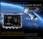
Local DM and shop owner claims that his iX3m GPS works underwater. He claims it has pointed him back to the boat (which he previously marked with a way-point), accurately at depths as deep as 15 feet, and maybe even deeper.
The GPS screen on the iX3m includes GPS strength and satellite lock count. He claims he's never looked at these readouts and cannot confirm or deny signal acquisition below the surface.
Known
What am I missing? Does the iX3m have an accelerometer and attempt to do inertial navigation? Highly unlikely. Does it do some crude navigation guesses based on the compass and tilt sensors?
I have suggested to this DM that he perform an experiment where he records the GPS strength and satellite lock count and depth during ascent or descent. He scoffs, and claims "well, it seems to be working".
So I ask you, the great Scubaboard community:
I'm quite frustrated. As an engineer, I've tried to analyze all possible explanations before I call BS. Maybe others here can help.
Situation
Local DM and shop owner claims that his iX3m GPS works underwater. He claims it has pointed him back to the boat (which he previously marked with a way-point), accurately at depths as deep as 15 feet, and maybe even deeper.
The GPS screen on the iX3m includes GPS strength and satellite lock count. He claims he's never looked at these readouts and cannot confirm or deny signal acquisition below the surface.
Known
- The iX3m supports several satellite networks, including the USA, Russian, and Chinese.
- All these networks use 1.2 to 1.6 GHz RF frequencies.
- Assuming no reflection of the signal at the surface (which is almost impossible, even at if the satellite is directly overhead), signals of that frequency would penetrate less than 1 meter of salt water.
- iX3m has an internal compass
- iX3m has some tilt sensors, as described in the Apps Manual
- The user manual specifically states:
"It is necessary to come to surface to allow the iX3M to link to satellites; the GNSS signal doesn’t cross the water’s surface." and "To save battery the satellite connection is active only when GPS App is running."
What am I missing? Does the iX3m have an accelerometer and attempt to do inertial navigation? Highly unlikely. Does it do some crude navigation guesses based on the compass and tilt sensors?
I have suggested to this DM that he perform an experiment where he records the GPS strength and satellite lock count and depth during ascent or descent. He scoffs, and claims "well, it seems to be working".
So I ask you, the great Scubaboard community:
- Has anyone used the iX3m to navigate underwater?
- If there is no good GPS data, why would the iX3m display possibly erroneous navigation guidance? I would think this is dangerous.
- Is the DM smoking something? (In other words, is he just confused or wrong?)
- Am I missing something?


