DIY GPS dive tracking

Please register or login

Welcome to ScubaBoard, the world's largest scuba diving community. Registration is not required to read the forums, but we encourage you to join. Joining has its benefits and enables you to participate in the discussions.

Benefits of registering include

  • Ability to post and comment on topics and discussions.
  • A Free photo gallery to share your dive photos with the world.
  • You can make this box go away

Joining is quick and easy. Log in or Register now!

I wonder if....

Just throwing this out there.
You know what a selfie stick is? Some are wired remote buttons that allow one to trip the camera shutter.

Wonder if you could pervert one of the wired ones to be submersible, and extend it with your towline? Then you could maybe possibly be able to mark waypoints.
There are GPS software that has time stamping in it. It is not a feature I am that in having. I have found that if you stay in one spot and pull in all the slack, you will have a mark that easy to identify and find again.
 
I would probably loop around the object of interest or make an east-west fin. Just thinking about people that might want to mark points, and not just a trip record.
 
I would probably loop around the object of interest or make an east-west fin. Just thinking about people that might want to mark points, and not just a trip record.
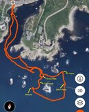
It is not that hard to identify locations of with on a dive Just sitting in one location will cause the flag to bob around. You can zoom in on your tracks far more than what I normally post, so it really is clearer than it might appear from the full view of the dive.

You can see I had no trouble marking points of interest on this dive that cover more about a mile of swimming
 

Attachments

  • dive locations.jpg
    dive locations.jpg
    85 KB · Views: 13
We take GPS points while diving for work. Set the GPS on your float to take a point every 1-10 seconds. Sync the time on your underwater camera to that of the GPS down to the second. When you want to mark a point of interest reel in the slack and take a picture. If the picture has your computer in it then you also have depth of that POI. Make a folder with the photos you want mapped and name the photos with something easy to identify (lobster hole). You can download the track on free programs like Garmin BaseCamp and drag the photo folder onto the track to get it geotagged. You can export the track with GPS points onto programs like excel if you just want the points or google earth and arcgis if you want and points on a satellite map.
DLAB Hull Grab.png
 

Back
Top Bottom