What are the chances that TS Rina will blow out out diving later this week or worse

Please register or login

Welcome to ScubaBoard, the world's largest scuba diving community. Registration is not required to read the forums, but we encourage you to join. Joining has its benefits and enables you to participate in the discussions.

Benefits of registering include

  • Ability to post and comment on topics and discussions.
  • A Free photo gallery to share your dive photos with the world.
  • You can make this box go away

Joining is quick and easy. Log in or Register now!

Not to be the voice of opposition, but this kind of attitude

he makes the good point that as usual he has tons of cancellations because people jump the gun and don't wait for a storm to shape up and declare its real intentions.

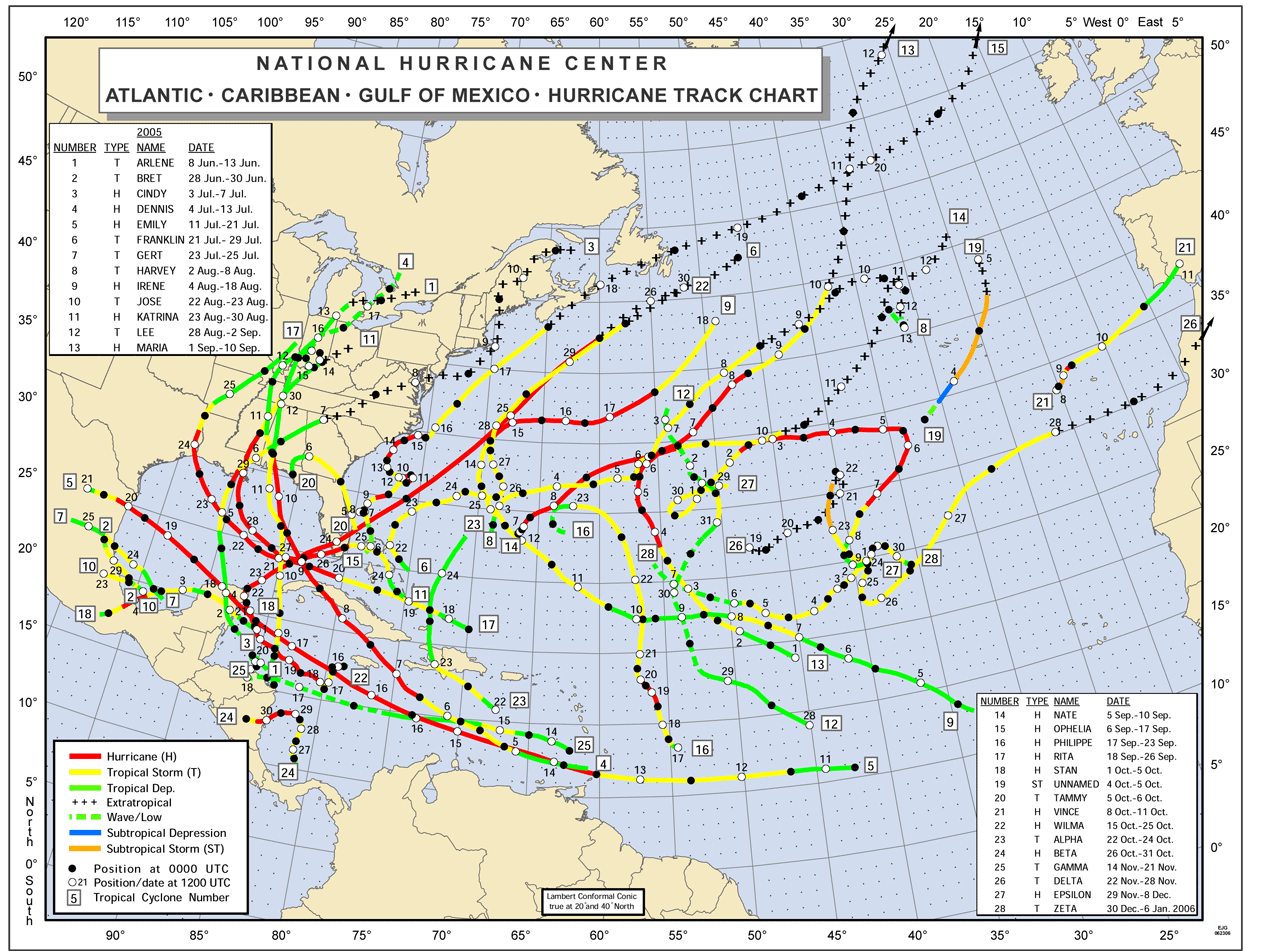
can cut both ways. In 2005, I watched and waited for a little puff of a storm called Wilma to "declare its real intentions", and with the storm at Cat 1 and Coz on the fringe of the 5 day track cone, I decided not to cancel and flew into Coz. By the time we got checked into our hotel and got back online that afternoon, we realized the storm had undergone explosive intensification and was a cat 4/5 monster now aimed directly at Coz. I still remember the shock in Christi's voice when she found out we were on the island and still remember the helpless feeling knowing there was no way we would get on a flight off the island before it hit. So while I know the prognosis of Rina is very different than Wilma, I won't ever question anybody's reasons for cancelling on a trip in the path of a hurricane again. Knowing what I know now, I would have done anything to have avoided that 2+ days riding out Wilma's wrath and the days of interminable waiting afterward with virtually no communications, desperate to find out when flights would resume and we might be able to get home.
 
Down to a cat 1! :D

Things don't look too bad from what I can tell from this live webcam shot on the Cozumel radio stations website...

Wheezer - "In an island in the sun we will be having fun..."
 

Attachments

  • 10-26-2011 2-29-37 PM.jpg
    10-26-2011 2-29-37 PM.jpg
    17.3 KB · Views: 205
  • Like
Reactions: Jax
Yeah, AggieDiver - I would still not go in before the storm. Waiting to see on weekend travel plans is doable, but no way I'd want to fly in before.

mfinley919, that is not a live cam screen shot you know? see http://yowindow.com/screenshots.php
 
Clouds are moving, a little boat is heading across the bay...

... does look a little more mountainous then I remember...

:idk:
 
4PM update

AT 400 PM CDT...2100 UTC...THE CENTER OF HURRICANE RINA WAS LOCATED
NEAR LATITUDE 18.2 NORTH...LONGITUDE 85.9 WEST. RINA IS MOVING
TOWARD THE NORTHWEST NEAR 6 MPH...9 KM/H. A GRADUAL TURN TO
THE NORTH WITH A SLIGHT INCREASE IN FORWARD SPEED IS EXPECTED
TONIGHT AND THURSDAY. ON THE FORECAST TRACK...THE CENTER OF RINA
WILL BE MOVING NEAR OR OVER THE EAST COAST OF THE YUCATAN PENINSULA
ON THURSDAY.

REPORTS FROM AN AIR FORCE RESERVE HURRICANE HUNTER AIRCRAFT INDICATE
THAT MAXIMUM SUSTAINED WINDS ARE NEAR 85 MPH...140 KM/H...WITH
HIGHER GUSTS. RINA IS A CATEGORY ONE HURRICANE ON THE
SAFFIR-SIMPSON HURRICANE WIND SCALE. LITTLE CHANGE IN STRENGTH IS
EXPECTED BEFORE THE CENTER OF RINA NEARS THE COAST OF THE YUCATAN
PENINSULA ON THURSDAY.

HURRICANE FORCE WINDS EXTEND OUTWARD UP TO 15 MILES...30 KM...FROM
THE CENTER...AND TROPICAL STORM FORCE WINDS EXTEND OUTWARD UP TO 105
MILES...165 KM.

THE MINIMUM CENTRAL PRESSURE ESTIMATED FROM THE HURRICANE HUNTER
AIRCRAFT DATA IS 979 MB...28.91 INCHES.
 
Not to be the voice of opposition, but this kind of attitude


can cut both ways.

I don't think the concern is about people canceling or postponing their arrivals scheduled yesterday, today or tomorrow. It's the ones canceling now for arrivals in the days to follow it's projected landfall and those encouraging it without knowing what the outcome is to be. Especially if you consider that 2005 was the single most active hurricane season on record. Whatever was going on, the Eastern Caribbean was an incubator for any tropical depression. The 2011 season is a month shy from being over but these 2 track maps speak form themselves:

2005:
2005atl.gif


2011:
prelimTrack_atlc_201109.png
 
Try a current map my friend.
97L, and a disturbance way out in the Atlantic is all that is currently on the radar.
One is already being downcast and the other will need time to understand. But, the long wave troughs are already parading across the gulf.
Not saying it cant happen, but aside from Rina and its apparent impacts the outlook is pretty good.
 
Glad to hear that Rina is down to Cat-1. :balloons: Yeah, if you can wait on deciding - hope for the best and still plan to go Sunday. No rush unless you have a lot of background details to decide on, like job, kids, dogs, etc.

So they turn the power off before a storm hits? I guess that's safer. Those generators are bad about CO fumes. Do they even sell h

ome CO detectors on the island? Be careful. Every bad storm in the US is followed by CO news stories. :(


don
sometimes i think you say this kind of stuff so we can all get a good laugh :D:D:D
 
Try a current map my friend.
97L, and a disturbance way out in the Atlantic is all that is currently on the radar.

Uh, yeah. That map does say "Preliminary" on it and its also missing the storm in question, Rina. The NHC doen't release finalized maps until the season is over but this was the best they had to emphasize MY point I was trying to make. Feel free to find and post a more current map from a more reputable source my friend. :eyebrow:
 
Last edited:
https://www.shearwater.com/products/perdix-ai/

Back
Top Bottom