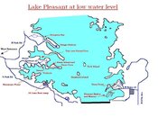
I wanted to expand upon what Ron (ReefMan) had added here on page 15 of this thread. The aerial photo is great but was taken at high water level. I have a poor quality attachment here you can click on and see a few features at Lake Pleasant now that the water level is low.
Burro Island and Cove is not really an island at all now but a peninsula, but when the water level goes back up it will disappear and no access by road will be possible.
The extension on the map I've made here, that is to the west of Vista Point will also be underwater, but at low water level there is more land to the west of the dirt road that is visible. It is also much harder to get to by vehicle when the water level is lower. When the water is higher though it is easier, and also the water gets deeper, faster there.
Desert Tortoise and Beismeyer point have areas of shallower water and it doesn't get deep, fast like Vista Point can get. Desert Tortoise Road goes right into the water at low level, but will also disappear when the water level is high. Great places for Scuba classes.
Humback Island and Tech Island are also visible during low water level. Both of those islands will be under about 30-40' of water when the lake level is up to max. Both are obviously only accesible by boat. Tech island by the way is awesome and has many ledges, overhangs and yes even fish. The Scubateers go out to that island alot. If you get the chance try it. Remember, during the winter that won't be an island at all and the ledges that are now only 20 - 30' under water, will be about 80' under water.
I just thought I'd leave this here so any new comers to diving Lake PLeasant might understand what everyone's talking about. Please let me know if something is wrong or I missed something important. These are just my observations from what I've been finding out from other local divers.