Lake Pleasant Diving

Please register or login

Welcome to ScubaBoard, the world's largest scuba diving community. Registration is not required to read the forums, but we encourage you to join. Joining has its benefits and enables you to participate in the discussions.

Benefits of registering include

  • Ability to post and comment on topics and discussions.
  • A Free photo gallery to share your dive photos with the world.
  • You can make this box go away

Joining is quick and easy. Log in or Register now!

Dove both sides of the lake last weekend.
East side had noticeably better visibility.

Planning on diving Sunday morning for anyone interested!
Need to tune up for my cave trip to Playa del Carmen on the 8th. :eyebrow:
 
anyone ben to the lake this month. i am wondering if the vis is like that river and is a lot clearer now that winter is killing the algae. or has it not got cold enough yet.

Hey Ed,

The vis was not to bad. I've certainly seen worse. The vis is about the same as it was last year. Diving this Saturday????:D:D:D

I'm looking for dive buddies for tomorrow but it looks like I'm out of luck.
 
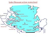
I wanted to expand upon what Ron (ReefMan) had added here on page 15 of this thread. The aerial photo is great but was taken at high water level. I have a poor quality attachment here you can click on and see a few features at Lake Pleasant now that the water level is low.

Burro Island and Cove is not really an island at all now but a peninsula, but when the water level goes back up it will disappear and no access by road will be possible.

The extension on the map I've made here, that is to the west of Vista Point will also be underwater, but at low water level there is more land to the west of the dirt road that is visible. It is also much harder to get to by vehicle when the water level is lower. When the water is higher though it is easier, and also the water gets deeper, faster there.

Desert Tortoise and Beismeyer point have areas of shallower water and it doesn't get deep, fast like Vista Point can get. Desert Tortoise Road goes right into the water at low level, but will also disappear when the water level is high. Great places for Scuba classes.

Humback Island and Tech Island are also visible during low water level. Both of those islands will be under about 30-40' of water when the lake level is up to max. Both are obviously only accesible by boat. Tech island by the way is awesome and has many ledges, overhangs and yes even fish. The Scubateers go out to that island alot. If you get the chance try it. Remember, during the winter that won't be an island at all and the ledges that are now only 20 - 30' under water, will be about 80' under water.

I just thought I'd leave this here so any new comers to diving Lake PLeasant might understand what everyone's talking about. Please let me know if something is wrong or I missed something important. These are just my observations from what I've been finding out from other local divers.
 

Attachments

  • Lake Pleasant 1.JPG
    Lake Pleasant 1.JPG
    76.3 KB · Views: 101
I wanted to expand upon what Ron (ReefMan) had added here on page 15 of this thread. The aerial photo is great but was taken at high water level. I have a poor quality attachment here you can click on and see a few features at Lake Pleasant now that the water level is low.

Burro Island and Cove is not really an island at all now but a peninsula, but when the water level goes back up it will disappear and no access by road will be possible.

The extension on the map I've made here, that is to the west of Vista Point will also be underwater, but at low water level there is more land to the west of the dirt road that is visible. It is also much harder to get to by vehicle when the water level is lower. When the water is higher though it is easier, and also the water gets deeper, faster there.

Desert Tortoise and Beismeyer point have areas of shallower water and it doesn't get deep, fast like Vista Point can get. Desert Tortoise Road goes right into the water at low level, but will also disappear when the water level is high. Great places for Scuba classes.

Humback Island and Tech Island are also visible during low water level. Both of those islands will be under about 30-40' of water when the lake level is up to max. Both are obviously only accesible by boat. Tech island by the way is awesome and has many ledges, overhangs and yes even fish. The Scubateers go out to that island alot. If you get the chance try it. Remember, during the winter that won't be an island at all and the ledges that are now only 20 - 30' under water, will be about 80' under water.

I just thought I'd leave this here so any new comers to diving Lake PLeasant might understand what everyone's talking about. Please let me know if something is wrong or I missed something important. These are just my observations from what I've been finding out from other local divers.

wow this is a great map. do you minde if i use it on my web site? i have updated the lake pleasant areas a bit if any one wants to check it out. the site navigates a little diforent in areas to try and make it easyer to understand. also i added a section on scuba history
 
Great map, Josh. It shows where the good spots are when the water is low.

Steve.
 
wow this is a great map. do you minde if i use it on my web site? i have updated the lake pleasant areas a bit if any one wants to check it out. the site navigates a little diforent in areas to try and make it easyer to understand. also i added a section on scuba history

Absoultely. This is for anyone. I thought it might just be a little easier for all of us to see some peninsulas that are present when the water is low.
 
I'm meeting Bill at Beismeyer Point on Saturday morning at about 8:00. (I'm tired of getting up at 0-dark-thirty to get to the lake by 7:00). I hear that the lake is rising. Come out and join us. Maybe we'll find the canopy that goes with the frame we recovered the last time we dove there.

Steve.

BTW. Still looking for GW. I'll get to try out my new dive lights if they get here in time.

Steve.
Just a quick reminder.

Steve and I will be at Beismeyer Point tomorrow morning at 8:00 am. Anyone who is interested in joining us is more than welcome.

Regards, Bill
 
Hey does anyone have a picture of the old dam? I have been looking for one but can't find any. Brett and I dove the dam on Wednesday and we hit the top of the structure at 70ffw and followed it all the way down to 200ffw, then wandered around to about 220 looking for some lost gear. What an impressive structure that was though! I would like to see what it looked like when it was out of the water.
 
Bill and Steve, I wish I could make it out there tomrorow but can't. Can't dive next Saturday either but I was thinking about doing a night dive next Friday the 21st. If anyone else can make it Friday night for a dive then I might plan to dive then.

- Josh
 
https://www.shearwater.com/products/perdix-ai/

Back
Top Bottom