Tropical Storm Ernesto 08/07/12 pass to the North of Bay Islands on to Belize

Please register or login

Welcome to ScubaBoard, the world's largest scuba diving community. Registration is not required to read the forums, but we encourage you to join. Joining has its benefits and enables you to participate in the discussions.

Benefits of registering include

  • Ability to post and comment on topics and discussions.
  • A Free photo gallery to share your dive photos with the world.
  • You can make this box go away

Joining is quick and easy. Log in or Register now!

Doc

Was RoatanMan
Rest in Peace
Scuba Instructor
Messages
10,954
Reaction score
4,127
Location
Chicago & O'Hare heading thru TSA 5x per year
# of dives
None - Not Certified
as of Monday morning 08/06/12

Picture20-11.png


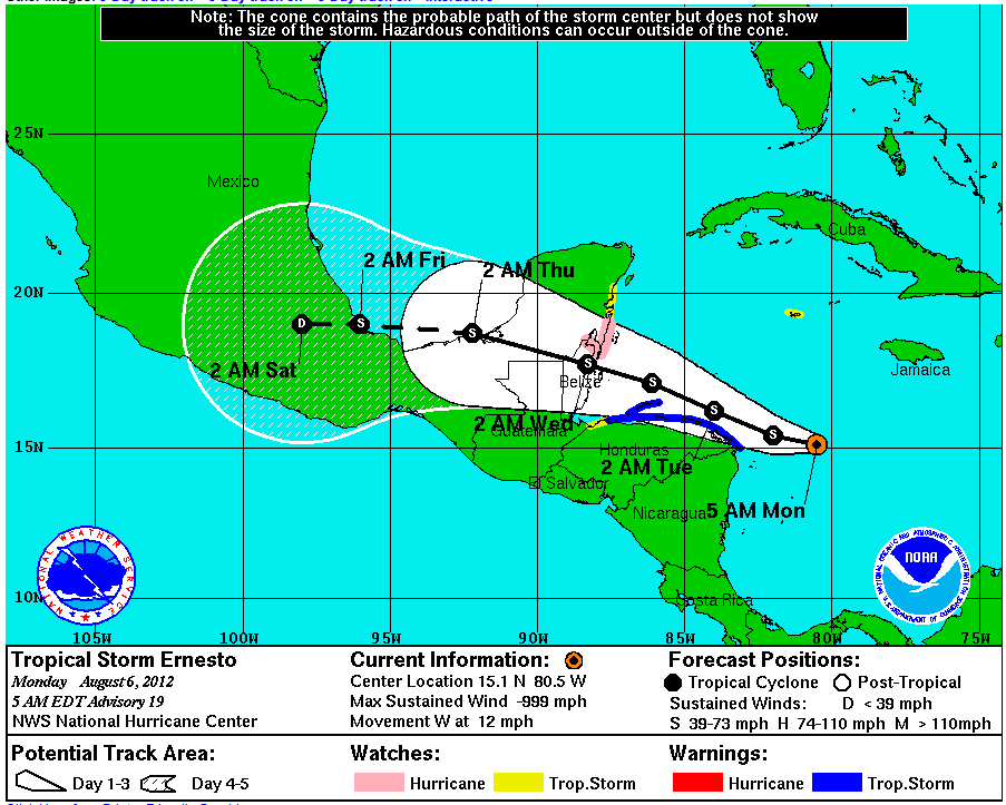
Typical of Tropical Storm/Hurricane tracking... at least this one is doing what it is "supposed to do".

Late Sunday night, the Belize landfall was predicted to be in Hurricane strength, but if you read this graphic, you'll see it was downgraded to TS (Trop Storm) status.

Looks like the North side and West End of Roatan are going to be bumpy for a few days.

The current data is always available at Jay's Hurricane Images - Real-Time Imagery of Tropical Storms
 
As is typical with storms to the North, It is like a pond on the Southside today, a light breeze from the north with some cloudsand a little rain earlier in the day. Lots of boats diving the southside this AM an now a whole heard is making its way over to spend the night and likely a few days.
 

Attachments

  • DSC_2966.jpg
    DSC_2966.jpg
    32.7 KB · Views: 336
it's been pretty nasty this afternoon (at least as far as i'm concerned)... wondering what it's going to be like tomorrow.
 
Here on the Southwest we got some rains for about an hour, nothing compared to many of our typical thunderstorms, As this thing gets closer and passes tomorrow i imgine the northll be feeling it more than we will, Hmmm, Maybe the Islanders were onto something when they decided where to begin, all the original settled areas such as Oak Ridge, French Harbor, Coxen Hole, Flowers Bay Etc.. are all on the South
Calm ad rain free now, seas 1-6 inches, plenty of clouds but that will just make for a darker night dive as we just went past the full moon
 
I guess i'm in the wrong spot being in west end then.... we'll see what happens tomorrow. just hoping things calm down pretty quick so we can get the boat again...
 
As of Tuesday, 0500 hrs, it has "lifted" (tracked North) another 25 miles, so the impact on the Bay Islands will be lessened.

Tropical Storm ERNESTO <- el clicko este linko

The downside to this? It has pumped back up to Hurricane strength and the entire Belize/Cozumel area is under a "warning".

As the season goes on, fewer storms will track this far South, most will adopt a clockwise spin and arc further North much earlier in their path.

As ERNESTO passes, keep your eye on the next bullet coming off of Equatorial Africa... So far, FLORENCE and the next Tropical Depression don't seem too dangerous, but, they have friends not yet born.
 
So as of right now we have some wind gusts and seas are a little sloppy though not much worse than a typical day on the southside except the seas are running the wrong way, west to east, occasional suges of rain so far since early AM. Ernie seems to be heading even further north , The heard of AKR boats has left the Southside and gone home, no one is boat diving as far as I can see, I guess they figure by Tomorrow they can dive their own backyard
 
Hi All

Here on Utila we got the same, yesterday a few high winds but today back to diving and it is very still now and clear we can easily see the mainland and the mountains 18 miles away.
 

Back
Top Bottom