old scuba park ?

Please register or login

Welcome to ScubaBoard, the world's largest scuba diving community. Registration is not required to read the forums, but we encourage you to join. Joining has its benefits and enables you to participate in the discussions.

Benefits of registering include

  • Ability to post and comment on topics and discussions.
  • A Free photo gallery to share your dive photos with the world.
  • You can make this box go away

Joining is quick and easy. Log in or Register now!

No I did not dive the site; I was brought in if the plans were to go forth.
We had planned the dives from a Pontoon boat.
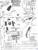
Our site was directly over the trees...

Drop in, mark the site for a later lift.
The coordinates were from a buddy- the one I am waiting on.
I apologize for the delay- he's in Europe diving.

Some of those lines go directly down to the river channel for Trimix training.

regards, Andrew
 
did anyone happen to get a lat/long or can you give some markers for someone who doesnt really know lake travis on how to get to the old park?

Thanks
 
Ok recreational dive just went out the door!
Talking to my buddy- the site is 150ft or deeper.

I confirmed what we know is rumor so- the larger boat you found could be it.
Sorry for any possible confusion.
We might have more information later this year.

Andrew


still want to find the shrimp boat in the trees. crazyduck did you ever make that dive? we did see a dive reel left on the bow. thought that might be yours from another boat we saw.
 
did anyone happen to get a lat/long or can you give some markers for someone who doesnt really know lake travis on how to get to the old park?

Thanks

the map posted is right, just some of the boats have moved. if you need a bigger view of the lake, let me know and I'll make a new one.
 
Nice job again on the pics w/ map layover...:clapping:

I'm gonna add this to my to-do list
 
I am a little confused by your scaling. Don Brod's office appears to extend pretty far out into the lake. Was the main building really that big. I was actually open water certified at Scuba Park in 1990 but have never been back so I really don't remember anything about it. I was trying to create the same overlay in Google Earth but started wondering about the scale.

Thanks

Layne

thanks. that is the reason for my post. i never dove the park when it was open and not sure of the lay out. i lined up the ramp with the concrete ramp on shore and the trees with the topo drop off. nobody answered the original question. does this look right? any more info would be appreciated. did the boarding ramp come off the concrete ramp as i have it? i have dived it twice sense the original post and it is close though.
 
Well, no not really. The buidling in the map is very large compared to the buildings found on Google. Placing the map overlay on google scaled the way you did makes the building in the map stick several hundred feet out into the lake. That is what I was commenting about. Sorry, I can't help you on that. the numbers on the left side of the map, is that a scale or does that represent depth?

thanks
 
here is the map i used. i got all the maps off this site to give credit where credit is due. all i did was overlay it. this must be an old map from when the park was open. the numbers represent depth.
 

Attachments

  • scubapark.jpg
    scubapark.jpg
    180.3 KB · Views: 74
Exactly, that is the one I am using and if you look at the bottom in the center, you will see the dock going out to the buildings. I think that dock should match up in size to the dock on Google Earth in the middle of the area where you placed the overlay.
 
https://www.shearwater.com/products/teric/

Back
Top Bottom