old scuba park ?

Please register or login

Welcome to ScubaBoard, the world's largest scuba diving community. Registration is not required to read the forums, but we encourage you to join. Joining has its benefits and enables you to participate in the discussions.

Benefits of registering include

  • Ability to post and comment on topics and discussions.
  • A Free photo gallery to share your dive photos with the world.
  • You can make this box go away

Joining is quick and easy. Log in or Register now!

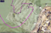
OK, i moved closer to the shore. there was a pontoon boat that was tied off the last boat. i used my electric trolling motor to get as close as i could safely get to that boat to get a gps reading. i do know that boat is in the right place on the overlay.
 

Attachments

  • pontoon boat.jpg
    pontoon boat.jpg
    122.4 KB · Views: 61
What is it you guys are doing with the map/overlays..??
 
What is it you guys are doing with the map/overlays..??

I'm just an observer, but I believe travisdude is trying to map the old scuba park on a google earth image using the image of an old flyer style dive map of the old scuba park.

According to the thread, travisdude never dove the park during operation, but now has opportunity to dive the site from offshore and take GPS readings (& often at that!). Seems like he's requesting info from those who knew and dove the old scuba park during its operation.

Keep up the good work travisdude!:bang:
 
What is it you guys are doing with the map/overlays..??

to start i just wanted to be able to find it. i have dove it twice now and have a feel for the layout. it would be nice to have a close record though. i still would like to find that shrimp boat crazyduck talked about. 150 ft may give me a good reason to take a mixed gas class.
 
"GPS readings (& often at that!)." those are the tracks of my boat from the gps. that big batch is were we anchored off to do our dive.
 
my status just went up half a star.
 

Attachments

  • post whore.gif
    post whore.gif
    6.9 KB · Views: 91
to start i just wanted to be able to find it. i have dove it twice now and have a feel for the layout. it would be nice to have a close record though. i still would like to find that shrimp boat crazyduck talked about. 150 ft may give me a good reason to take a mixed gas class.

I don't know about a mate with a name like 'crazyduck'...might be just something too that...... :eyebrow:

Once you get a better handle on this 'shrimp boat'....I would be happy to drop down for a look...not a problem.

Good luck on your exploration and mapping!!
 
Thanks Alan :D Just what friends are for.
Pm heading to you on separate topic.

Duck is back to the pool for training... soon enough.
Might be stealth dux soon...

For mix above 200 feet there is Normoxic Trimix.
IANTD Normoxic Trimix Diver program is aimed at those who wish to dive in the zone between 130 fsw and 200 fsw. Just a thought.

Later, Andrew

I don't know about a mate with a name like 'crazyduck'...might be just something too that...... :eyebrow:
 
Thanks Alan :D Just what friends are for.
Pm heading to you on separate topic.

Later, Andrew

.......... I could not resist myself....I know it was 'bad' of me.... the duck rocks!!! :D
 
my status just went up half a star.

Quick question for you. I have made the overlays but everytime I close google earth and then reopen it, those overlays are gone and there is a big red X in their place. I also get a message stating it could not find the images.

How do you make the image stay with my google earth file?

thanks

Layne
 
https://www.shearwater.com/products/perdix-ai/

Back
Top Bottom