Inexpensive SONAR locates stolen vehicle in OK

Please register or login

Welcome to ScubaBoard, the world's largest scuba diving community. Registration is not required to read the forums, but we encourage you to join. Joining has its benefits and enables you to participate in the discussions.

Benefits of registering include

  • Ability to post and comment on topics and discussions.
  • A Free photo gallery to share your dive photos with the world.
  • You can make this box go away

Joining is quick and easy. Log in or Register now!

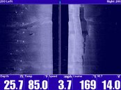
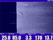
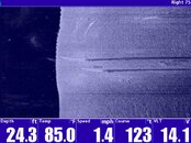
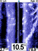
I have had my Humminbird 797c2 since 2007. I have located numerous stolen cars, sunk boats and have even painted my "body" near a sunken pirogue (upper right corner). I have some other really good images but they are too big to upload here. If someone can fix these I can send them, to you, so they can be posted. It is a great tool. I gave less then 1k for mine.
 

Attachments

  • Body and pirogue.PNG
    Body and pirogue.PNG
    97.8 KB · Views: 136
Blades assisted my fire department with the purchase of an 1197c SAR through Dive Rescue. We installed the SS on our fire department pontoon boat and took it out for some "testing". In two sessions of approximately 1 1/2 hours each, we managed to identify 4 vehicles in the river. Our water depth ranges from 10 to 40' and it the ratio makes vehicles stand out rather prominently. A couple of things I have learned.

1) After a target is identified with scanning both sides, we switch to the appropriate side of the boat and do single side scanning with 50 to 75 range. This seems to offer the best resolution at the recommended 2 to 3 mph.

2) Make several passes from various directions. Each direction provides a different view.

3) Make certain to take and use an SD memory card to be able to capture images and review them later.

Certainly not a full blown SS unit, but very good tool for the tool box for the money.

Dan
 
gallery_photo


The Honda Passport was in 13-foot deep water where the temperature was about 45 degrees.
".


just goes to show how the media can get facts wrong in the story.


Media says the vechicle was 13ft deep in 45 degree water.

Sonar says that it's 5.5ft in 54f water.

Maybe the boat "shallowed up" as it went forward, but I doubt the surface temp got 10 degres water in a few more feet. :shakehead:
 
Boater Dan: There's likely an option, if the unit is also a GPS chartplotter,
point to the target and say "Make a waypoint THERE". Then you can
come back again and drop a buoy. And if your buoy has a decent-sized anchor,
you can come back with the SS, see both the target and the anchor, and
then tell the divers that the target is X feet NNW of the buoy anchor. This
avoids the search in the immediate area of the buoy anchor.
 
just goes to show how the media can get facts wrong in the story.

Media says the vehicle was 13ft deep in 45 degree water.

Sonar says that it's 5.5ft in 54f water.

Maybe the boat "shallowed up" as it went forward, but I doubt the surface temp got 10 degrees water in a few more feet. :shakehead:


Mike,

Congrats on paying attention to detail. It is too bad that the media doesn't always do the same. As a point of FYI though, I will point out for the benefit of those who are not 100% familiar with sonar imagery that you can tell that the water is getting shallower (or the transducer is getting closer to the bottom) because the dark area in the center of the image represents the height of the sonar transducer off of the bottom. Because the transducer is mounted on the boat transom, the dark represents depth (or that the boat is sinking :rofl3: ).

The area marked "shoreline" at the top of the screen is also an indicator that the boat is entering shallow water, in this case, 5.5 feet. You can see that in the area of the boat ramp, the dark area in the center of the image is thick (deeper) and at the top portion of the image the dark area at the center is thin (shallower).

Not to defend the media, the temperature difference may be explained by a thermocline or the temperature reported by the divers at depth. There could be a difference between the diver's gauges and the temperature sensor on the transducer.

My point though is to show how the center line on the image being thick or thin can be a helpful tool as it represents depth and/or height of the transducer off of the bottom. In a towfish configuration the height of the towfish can also represent boat speed. If speed is decreasing the towfish will sink lower and get closer to the bottom (unless the operator is retrieving cable at a proper rate).

Kudos again to paying attention to the details. With a few tips, one can see how easy it is to use one of these units.

Regards,

Blades
 
Figured I would add a couple pics I took using our new 1197. The first one has a submerged road and bridge on the right and the white dots are the pillars of the current bridge. The second is a 18ft utility trailer that went off the bridge during an auto accident, and the third we are unsure if it a sunken pontoon boat or what? It kinda looks like a car as well,... but not likely since no accidents have been reported or even guardrail damage.

Johnny Millwood
 

Attachments

  • S00008.jpg
    S00008.jpg
    88.7 KB · Views: 111
  • S00017.jpg
    S00017.jpg
    102.8 KB · Views: 106
  • unknown001.jpg
    unknown001.jpg
    109.3 KB · Views: 112

Back
Top Bottom