A BLOWOUT?

Please register or login

Welcome to ScubaBoard, the world's largest scuba diving community. Registration is not required to read the forums, but we encourage you to join. Joining has its benefits and enables you to participate in the discussions.

Benefits of registering include

  • Ability to post and comment on topics and discussions.
  • A Free photo gallery to share your dive photos with the world.
  • You can make this box go away

Joining is quick and easy. Log in or Register now!

the High Springs area might be spared a direct hit
Yea cool.

The Wind Speed Probability Model shows an 80-90% chance of Tropical Storm Force wind here in High Springs.

speeds.png
 
The Wind Speed Probability Model shows an 80-90% chance of Tropical Storm Force wind here in High Springs.

Yeah it is still going to be a lot of wind and rain, just might not be the full major hurricane force winds.

Though TBH with the building code improvements since Andrew it likely won't change things much, as the power grid damage and flooding is probably the major threat for Cave Country. I went to my home just outside of North Port the day after Ian, the eye went directly over the area, there was little structural damage. Most of Ian's damage was due to the Storm Surge and river flooding further south.
 
Sorry guys, covered up at work.
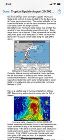
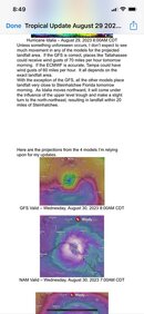
Here is a screen shot of latest.
Manatee Diver is very spot on, you need a job? :D we would take you!!
 

Attachments

  • IMG_7184.jpg
    IMG_7184.jpg
    89.1 KB · Views: 57
  • IMG_7185.jpg
    IMG_7185.jpg
    58.3 KB · Views: 54
New NHC forecast is out, no major changes. They suggest that the maximum winds before coming ashore will be 110kts, which is on the lower end of the 110-120kts range that they were predicting this morning.

Model wise no real changes other than the curve around is being reflected by most models now.
AL102023_5day_cone_no_line_and_wind.png
10L_tracks_latest.png
10L_intensity_latest.png
 
The Gulf has never been this warm, so we'll see what punch she packs. The spaghetti models seem to put it through Lafayette County, which will be bad for the caves. They are expected to have it remain a hurricane into Georgia.
 
The storm is now a CAT 2 and the eye looks about even with Naples on the radar. It is raining on and off where I am at. NHC forecast still doesn't show much new, they still expect 110kts at landfall. They do warn that because it is fast moving that it will probably continue to keep the energy up further inland than what we are used to.

Models don't show much new until after it gets out into the Atlantic, models seem to be mixed on if it curves around completely.

Peak surge forecast has been updated to has high as 10-15ft near the area where it makes landfall. Little changes in the rain forecast but the flash flood level chances have lowered for much of the High Springs area.

AL102023_5day_cone_no_line_and_wind.png
10L_tracks_latest.png
10L_intensity_latest.png
10L_peak_surge.png
10LRain.gif
 
Limited to dive images here is the flash flood forecast.

I have the two up weather channel and fox weather on mute. Only time of year that I tune in.
10LFlashFlood.gif
 
Also I don't know what everyone else uses for radar and sat images, but I like the NOAA's Aviation Weather.
 
Storm Radar app - the paid version. I use it in Key Largo when running dive boats..its REAL TIME with accurate forecasted animated imagery.
29AG1726.jpg
 
Back
Top Bottom