Have you seen the photos of Ginnie when the water is covering or close to covering the bath houses?That is crazy how high that is.
You are using an out of date browser. It may not display this or other websites correctly.
You should upgrade or use an alternative browser.
You should upgrade or use an alternative browser.
A BLOWOUT?
- Thread starter Capt Jim Wyatt
- Start date
Please register or login
Welcome to ScubaBoard, the world's largest scuba diving community. Registration is not required to read the forums, but we encourage you to join. Joining has its benefits and enables you to participate in the discussions.
Benefits of registering include
- Ability to post and comment on topics and discussions.
- A Free photo gallery to share your dive photos with the world.
- You can make this box go away
Capt Jim Wyatt
Hanging at the 10 Foot Stop
Staff member
ScubaBoard Business Sponsor
ScubaBoard Sponsor
ScubaBoard Supporter
Scuba Instructor
Divemaster
Yes, that happened during T.S. Debbie too.Have you seen the photos of Ginnie when the water is covering or close to covering the bath houses?
I'm going to Ginnie in the morning. Early.
Have you seen the photos of Ginnie when the water is covering or close to covering the bath houses?
I have but the bridge picture makes it clear the total water level.
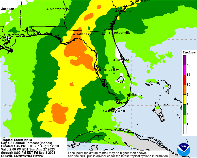
It is officially tropical storm Idalia. The official NHC forecast now reflects this morning's models, and this afternoon's models have no major changes. But the rain forecast is out. That is a lot of rain locally and up in Georgia so a blowout seems likely.
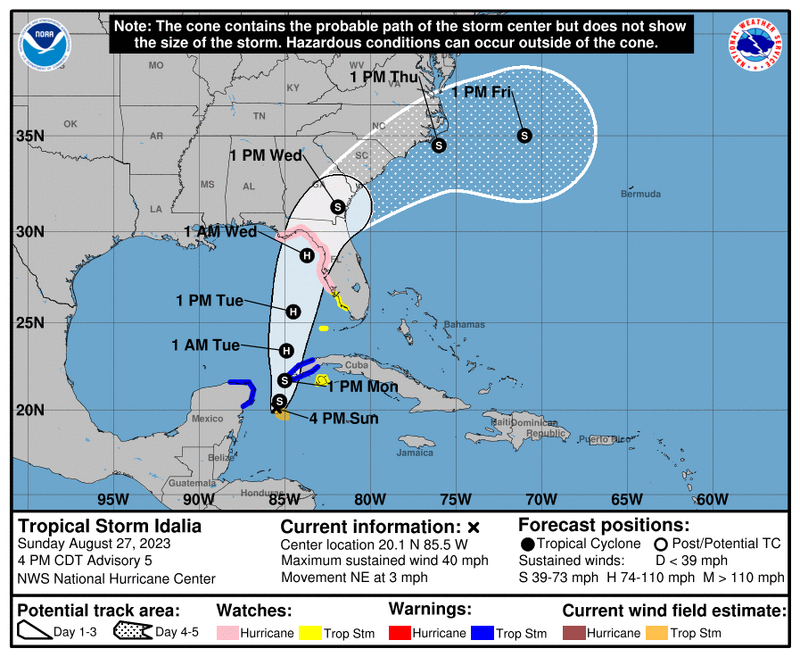
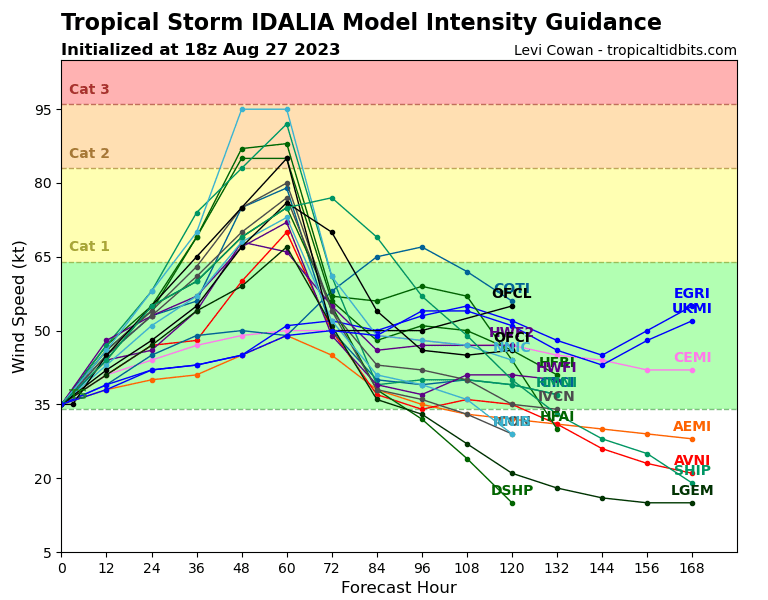
Hurricane watches have been issued from Cape San Blas down to Charlotte Harbor. I also saw that the intensity forecast is now showing it will likely be a cat 1 based on current conditions with the possibility of being a cat 2. No idea if they improved their intensity forecasting since last year, it seems to often be an underestimation for storms coming from the Gulf.
Capt Jim Wyatt
Hanging at the 10 Foot Stop
Staff member
ScubaBoard Business Sponsor
ScubaBoard Sponsor
ScubaBoard Supporter
Scuba Instructor
Divemaster
Hurricane watch in the big bend - Cedar Key

NHC's forecast has trended a tad south, but the models are trending together with no major outliers that older models had. Intensity forecast has trended lower with most agreeing on a cat 1, but the discussion emphasizes that intensification to a major hurricane is very possible. Rain forecast doesn't appear to have changed.
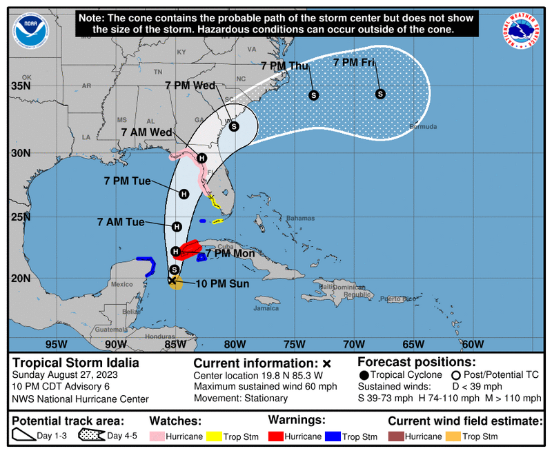
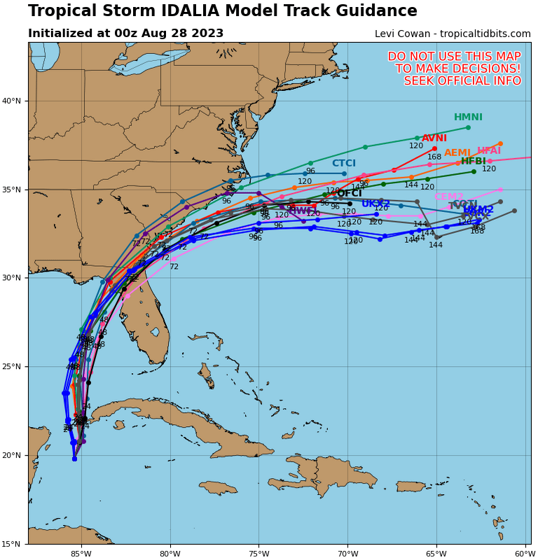
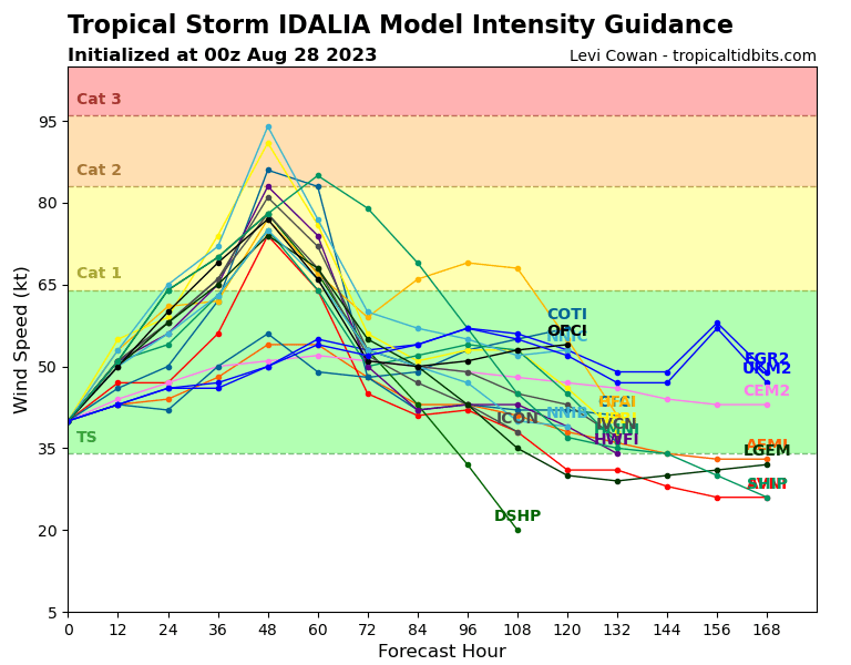
Current predictions are calling for it to rapidly intensify to a possible cat 3 before landfall, going to cat 2 prior to landfall. This is due to projected pressure changes taking effect at 30,000 feet tomorrow evening an through Tuesday. They are expecting it to pick up traveling speed as well, so hopefully it will not stall and drop an absorbent amount of rain...
We are also currently testing some different models with this storm. Much shorter 5ime ranges, but supposedly more accurate forecast. We shall see...
Capt Jim Wyatt
Hanging at the 10 Foot Stop
Staff member
ScubaBoard Business Sponsor
ScubaBoard Sponsor
ScubaBoard Supporter
Scuba Instructor
Divemaster
Who is "We"?We are also currently testing some different models
Similar threads
- Replies
- 2
- Views
- 1,224
- Replies
- 8
- Views
- 2,889


