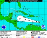
I know that AKR will move their boats to the south side. I am not overly concerned but I am aware of the possibility. Who knows, it might be more of an adventure than we had planned.
You are using an out of date browser. It may not display this or other websites correctly.
You should upgrade or use an alternative browser.
You should upgrade or use an alternative browser.
Ernesto closes on the Windward Islands and the Caribbean
- Thread starter DandyDon
- Start date
Please register or login
Welcome to ScubaBoard, the world's largest scuba diving community. Registration is not required to read the forums, but we encourage you to join. Joining has its benefits and enables you to participate in the discussions.
Benefits of registering include
- Ability to post and comment on topics and discussions.
- A Free photo gallery to share your dive photos with the world.
- You can make this box go away
Magnolia3
Contributor
I figure even if it goes as far north as some predictions it will still cause rough seas in Roatan keeping the dive boats from going out. I am suppose to be there Monday to Friday. I am considering a last minute change and giving up my deposits and going to the Bahamas. I have heard NOAA is sending a plane out this afternoon and should have an updated report by 5pm.
Might want to reconsider the bahamas... Invest 91L is on the western edge of the bahama bank.
working theory is to move north, then nw across fla.. in the next few days...
---------- Post Merged at 09:55 PM ---------- Previous Post was at 06:57 PM ----------
here ya go. just posted on the FB page for Protecccion Civil Yucatan. ( cannot get on the quintana roo page it it is full) besides it is crappy..

Protección Civil Yucatán
El Centro de la Tormenta Tropical Ernesto se estima esta mañana a 660Kms al Sureste de San Juan Puerto Rico, a 2,800Kms de Popolnah, Comisaría de Tizimín; la Tormenta Tropical continúa presentando un rapido desplazamiento hacia el Oeste a razón de 33Km/h.
Ernesto presenta vientos sostenidos de 85Km/h, los cuales se extienden hasta 95Kms hacia el Nororeste de su Centro, por lo que vientos de Tormenta Tropical son estimados a 2,705Kms de Popolnah, Comisaría de Tizimín.
Se decreta en efecto Alerta Azul para el Estado de Yucatán en el marco del Sistema de Alerta Temprana para Ciclones Tropicales SIAT-CT.
Se espera que la Tormenta Tropical Ernesto continúe presentando un rápido desplazamiento general hacia el Oeste sobre el Mar Caribe, en la trayectoria pronóstico, la cual aún se encuentra sujeta a modificaciones a cada seis horas, el Centro de Ernesto se encontaría en las inmediaciones de Cozumel, Quintana Roo, hacia la mañana del Miércoles, posiblemente como un huracán.

http://www.facebook.com/pages/Protección-Civil-Yucatán/121889244506446
Jungho Kim
Contributor
It looks like it is headed straight for Cozumel... I hope this blows through by Aug 12th... I am heading to Cozumel for a week of diving...
- Messages
- 54,470
- Reaction score
- 8,575
- # of dives
- 500 - 999
Followed by Florence.Might want to reconsider the bahamas... Invest 91L is on the western edge of the bahama bank.
working theory is to move north, then nw across fla.. in the next few days...
Even if he goes that way, he'll be gone by the 8th. Things will be back to normal by then surely.It looks like it is headed straight for Cozumel... I hope this blows through by Aug 12th... I am heading to Cozumel for a week of diving...
Watch Florence tho, in case she veers south.
ssroseberry
Guest
- Messages
- 20
- Reaction score
- 5
We decided to stay with Roatan, but taking ponchos and shoes for walking on muddy streets. Hopefully we can get a day or two of diving in. I did call the dive op. (thanks for the idea) and they said they will move to the south side if they need to.
We are on Roatan now. Will keep you all posted.
- Messages
- 54,470
- Reaction score
- 8,575
- # of dives
- 500 - 999
Where are you staying?We are on Roatan now. Will keep you all posted.
Where are you staying?
Anthoy's Key
Damselfish
Contributor
The Captains Blog -: Tropical Storm Ernesto Update (Ocean Frontiers East End Cayman)
- Messages
- 54,470
- Reaction score
- 8,575
- # of dives
- 500 - 999
The bad news is he's shifted to come straight for you - subject to change.Anthoy's Key
The good news is he's losing power. A Tropical Storm is just a blow out with flooding.
Similar threads
- Replies
- 1
- Views
- 1,232
- Replies
- 22
- Views
- 8,821


