The Great Travis Traverse

Please register or login

Welcome to ScubaBoard, the world's largest scuba diving community. Registration is not required to read the forums, but we encourage you to join. Joining has its benefits and enables you to participate in the discussions.

Benefits of registering include

  • Ability to post and comment on topics and discussions.
  • A Free photo gallery to share your dive photos with the world.
  • You can make this box go away

Joining is quick and easy. Log in or Register now!

Did you hit the line? Odd that you got 77 on the bottom...a few weeks ago I got 72, but now that you mention it, I didn't notice a thermocline dropping into the riverbed this week. Never checked temp though. Did the lake turn in the last few weeks?

We've noticed lots of dead little fish too...and the lovely stinch of H2S. Vis Wed night was about the same @ depth...maybe 8ft in the riverbed at best...

Yep it was still nice and 'cozy' on the river bed (both my computers had same readings on temps)....did not notice the odor or any sights of dead fish--hmmmm. The lake will not turn until the surface water cools sufficantly for it to sink forcing the bottom waters up. Vis like I said was at least in my standards good at depth.
 
That's what I thought...so what happened to the cooler water we had in the channel a few weeks ago? Is the lake still warming? The dead fish we're seeing are small...like 2" or less. Although, I did see a large decomping catfish down there about a month ago...

Pull your reg outta your mouth next time...you'll smell it! :P
 
HI.... all going well thanks for asking.......we need to hook-up for some more diving for sure.

Had planned on doing some sunken bridge diving in Oct. up in Mo., but the weekend was 'conflicting' with a run to Arkansas.

Best wishes on your classes and your up and coming travels.

Be safe my friend! ;)

I'll be at Lake Travis this weekend teaching a few classes. After that, my schedule gets hectic with repeated trips to Florida in October, where I will remain until mid-November. Then a couple weeks later, I will be in Grand Cayman for a couple of weeks.

Looking forward to meeting up to get some more diving in with you.
 
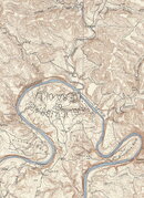
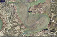
1930s topo

travis topo 2X.jpg

topo overlay.jpg here is a 1930s topo map that may help. this is my first post so i hope i did it right. i overlayed it on google earth. trust me it took a lot of playing with it to get it to work. you can zoom in on the topo map. if you would like a link , let me know the original zooms in better.
 
So what's the latest on the Great Traverse???
 
The earliest I can get in the water now is October 20th, and its burnin me up big time.

I have line and stakes ready to go, just can't get down there yet.
 
View attachment 40472

View attachment 40473 here is a 1930s topo map that may help. this is my first post so i hope i did it right. i overlayed it on google earth. trust me it took a lot of playing with it to get it to work. you can zoom in on the topo map. if you would like a link , let me know the original zooms in better.

Any chance you would be willing to post the google file as well?

appreciate the hard work

Layne
 
Texas Topographic Maps - Perry-Castañeda Map Collection - UT Library Online here is the link to the topo. click on it and go to MtBonnel(Travis County). i am not sure how to link to the google earth file. i just overlayed it on the google earth on my computor. if you know how let me know, i'll be glad to do it. i have some questions about the topo, but i don't want to hijack this tread. will start a new thread for that. and thanks for all the welcome post.
 

Back
Top Bottom