The Great Travis Traverse

Please register or login

Welcome to ScubaBoard, the world's largest scuba diving community. Registration is not required to read the forums, but we encourage you to join. Joining has its benefits and enables you to participate in the discussions.

Benefits of registering include

  • Ability to post and comment on topics and discussions.
  • A Free photo gallery to share your dive photos with the world.
  • You can make this box go away

Joining is quick and easy. Log in or Register now!

Nice! I don't think we have a time frame really. We've done most of the recon, and now the new line team is crossing the river from a true East to West as phase 1 on the weekend of the 28th. Beyond that...I guess we take it a step at a time?

This is fairly loosely organized and open to anyone with the proper training. We can work on finishing the traverse after the riverbed crossing, or we can start doing some mapping...we'll just see how it plays out and who's able or willing to do what. Past what Fixxer is doing to cross the old riverbed, we aren't gonna be able to lay new line without scoots or dropping back onto the line. Boat action would come into play in both the mapping and laying of new line from mid-water if we go that route. Hopefully it will be nice and cold by then so we can make this as difficult as possible and freeze our arses off in the process. I would invite anyone and everyone to brainstorm about ideas for moving forward...
 
Interesting. Last dive I did to the River Channel was a couple of weeks ago.There was a strong taste of hydrogen sulfide in places and we came across quite a few small dead fish on the bottom.

Could the film be some sort of anaerobic bacteria that is flourishing in the unusually warm temperature? Or maybe its just Travis gunk :D

I didn't notice any smells but I did see the dead fish.. made me wonder what the hell I was swimming in exactly.
 
Nice! I don't think we have a time frame really. We've done most of the recon, and now the new line team is crossing the river from a true East to West as phase 1 on the weekend of the 28th. Beyond that...I guess we take it a step at a time?

This is fairly loosely organized and open to anyone with the proper training. We can work on finishing the traverse after the riverbed crossing, or we can start doing some mapping...we'll just see how it plays out and who's able or willing to do what. Past what Fixxer is doing to cross the old riverbed, we aren't gonna be able to lay new line without scoots or dropping back onto the line. Boat action would come into play in both the mapping and laying of new line from mid-water if we go that route. Hopefully it will be nice and cold by then so we can make this as difficult as possible and freeze our arses off in the process. I would invite anyone and everyone to brainstorm about ideas for moving forward...

I'm working on a 3D map since I can't dive this weekend I'll try to fill my time some other way.
 
If you guys are making regular visits take a page from the DIR playbook and ask LCRA if you could put in water sampling tubes and recover them on a regular basis.
You could also measure silt height, density, and water samples.
QUOTE]

Has anyone taken the task to contact the LCRA yet?
 
I would invite anyone and everyone to brainstorm about ideas for moving forward...
Here is something I wanted to run by everyone.

Step 1: Team A goes down to edge of the riverbed at Windy point (Eastside) ties off
on to a existing stake and shoots a bag with the reel attached to the bag
(Note:need to set drag so no crows nest happens.)Team then ascends
with the bottom back to windy point exiting in the shallows.

Step 2: Team B descends down to 20'of depth on the (Westside) of the lake they
drive a stake & tie line and proceed East laying line and setting stakes
every 100' feet when they get to the riverbed or 150' of depth which ever
comes first they drive a stake & shoot a bag with the reel attached to the
bag (Note:need to set drag so no crows nest happens.)
Team B then ascends with the bottom following the line back up to the
shallows. Once on the surface a boat picks up Team B.
They retrieve their bag & reel at the surface, they remove the reel and tie
the upline to a HUGH supply of line and start across the lake East heading
to the bag that Team A shot. While they are motoring across the lake they
are deploying mainline.

Step 3: Team A swims out to hookup with the boat at the (Team A bag)
Team A attaches the mainline that just arrivived from across lake to a empty reel .
They then descend down the (Team A bag) upline , taking up the slack of
the mainline as they descend.
Once they arrive to the tie off at the riverbed, they tie the mainline to it.
They then cut the upline free.
They then ascend with the bottom, back to windy point exiting in the
shallows. once on the surface the boat
retrieves the bag with the upline.

You now have a Mainline that goes from Windy point to the westside of the
lake. This should be a very helpful aid for
teams wanting to plan and execute The Great Travis Traverse.
Also additional stakes & line markers should be installed to fine tune and
bring the line to the correct elevation along the riverbed.

A good option for a boat would be to charter
Bubba's Dive boat it would be ideal for the
surface support & transportation across the lake.
He has plenty of room for gear.

Dave
 
Just got back from diving WP private today. In general the vis top/bottom of the water column has lessened just a tad from my dives last Friday. The best 'clear' water I found during my 3 dips was in the column from 80 to 115ffw approx. ....below around 130ffw the vis was reduced to anywhere from 4-6ft. with a 'reddish-brown hue' and some suspension in the water. Temps have only dropped a few degrees. No odor or dead fish.

170ffw/77f
161ffw/78f
143ffw/79f

Had the site to myself with the exception of a fellow who did 1 dive while feeding the fish at the platform--lol. Watch out for dropping acorns!!

:14:
 
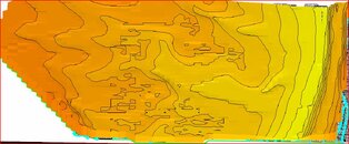
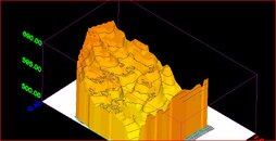
The data on the windy point side was rather hard to read so I had to fudge it just a bit, but hey, we all know what the windy point side looks like.

On the opposite side I tried to be a bit more accurate but had to do just a hair of fudgein on that side as well due to quality of the topo but you'll get the idea, I've twisted the vew around a bit to get a sense of scale compared to the windy point side, LOTS of swimmin after you clear the channel.
 

Attachments

  • Stretch view.jpg
    Stretch view.jpg
    116.6 KB · Views: 184
here is a different prespective to get more of a comparison of the lay compared to windy point. windy point is the side of the image that would "have its back to you" as your looking at it to put the majority of the opposite side of windy point into view.
 

Attachments

  • opposite.JPG
    opposite.JPG
    96 KB · Views: 194
Teknad, great idea...but I think we're set to do it all at depth already? I guess you could say we want to do it the hard way!

Thinking from some of your ideas though, starting on the end of the new line at depth and working shallow would probably be the best way to complete the traverse line: A-Team (pun intended) swims out to end of new line, pops the bag...B-Team descends up-line and starts laying line in a pre-determined direction from deep to shallow West bank. Only thing we'd need to co-ordinate is the availability of 2 dive teams and a boat on the same weekend...

Fixxer, great new topos!
 
Just got back from diving WP private today. In general the vis top/bottom of the water column has lessened just a tad from my dives last Friday. The best 'clear' water I found during my 3 dips was in the column from 80 to 115ffw approx. ....below around 130ffw the vis was reduced to anywhere from 4-6ft. with a 'reddish-brown hue' and some suspension in the water. Temps have only dropped a few degrees. No odor or dead fish.

170ffw/77f
161ffw/78f
143ffw/79f


:14:

Did you hit the line? Odd that you got 77 on the bottom...a few weeks ago I got 72, but now that you mention it, I didn't notice a thermocline dropping into the riverbed this week. Never checked temp though. Did the lake turn in the last few weeks?

We've noticed lots of dead little fish too...and the lovely stinch of H2S. Vis Wed night was about the same @ depth...maybe 8ft in the riverbed at best...
 

Back
Top Bottom