Fired for doing science. Go figure.Zeta seems to be landing as a Cat-2, TS warnings are far as Virginia, and NOAA's chief scientist was fired. Keep those paper towels stocked.
You are using an out of date browser. It may not display this or other websites correctly.
You should upgrade or use an alternative browser.
You should upgrade or use an alternative browser.
Hurricane Zeta
- Thread starter k4kafka
- Start date
Please register or login
Welcome to ScubaBoard, the world's largest scuba diving community. Registration is not required to read the forums, but we encourage you to join. Joining has its benefits and enables you to participate in the discussions.
Benefits of registering include
- Ability to post and comment on topics and discussions.
- A Free photo gallery to share your dive photos with the world.
- You can make this box go away
Fired for doing science. Go figure.
And replaced with yet another climate change skeptic yes-man. Go figure.
- Messages
- 54,470
- Reaction score
- 8,575
- # of dives
- 500 - 999
They are pricey, but at least we have the technology nowadays. It gets boring checking tanks with zero after zero until you get your first bad tank.DandyDon, OT, but I recently purchased a Palm CO detector based on the arguments from you and some other participants. Pretty darn expensive, alas.
You bet. It also gets boring to smell your gas as a proxy for CO detection. I saw a video recently where the old guy with infinitely more experience than I said that we don't have to worry about CO if the dive shop follows North American standards. Welp, I don't think most of our dive locations do that.They are pricey, but at least we have the technology nowadays. It gets boring checking tanks with zero after zero until you get your first bad tank.
Anyway, I just wanted to do a shout out!
Thanks for posting these. Glad to see Matt & Angie are okay. Hopefully William gets Rastas put back together.Here are some photos from Mateo. He tells me the Rasta Bar roof is heavily damaged but the photo looks repairable plus some other shot's from town. Otates (whatever the new name is) lost its roof.View attachment 620641 View attachment 620642
Rumors of another storm definitely floating around the marina (friend called me to ask what was up) , but there is nothing on the 5 day NHC tropical forecast map. Article did talk about next week, which would put it past 5 days so that does make some sense. GFS model seems to shows a weak tropical system going into Nicaragua about 7 days from now. That may be what Mexican news was picking up. Looked like just a depression/wave. Didn’t see anything on the European model (which is better than GFS for most things). Obviously if GFS system went north instead of west it could be a problem for Cozumel late next week with 48 more hours over warm water , but that is a double hypothetical (hypothetical course change on hypothetical storm ).
Water in Caribbean still warm for this time of year and warm in general. I was hoping these storms would have cooled it some, but if they did it was a trivial amount. I gather the strong La Niña phase we are in means higher hurricane risk due to less wind shear over Caribbean.
While NHC long term (72 hour plus ) track forecasting hasn’t been that great this year when Cozumel was involved , they were certainly right when the upped hurricane frequency forecast for the season back in August due to expected La Niña
[La Nina develops during peak hurricane season | National Oceanic and Atmospheric Administration]
Bottom line , I don’t really see a real storm on the various forecasts/models at this time. There is a possible system on one model , but as of now it is not forecast to hit Cozumel (or be much of a storm ). But then Delta and Zeta weren’t supposed to hit Cozumel if you looked at models 4 days out or more, so we still have to wait and see if things go from bad to worse like everything else in 2020.
I am still in states but hopefully will return to Coz soon. Not much damage in my condo but we building did have odd water issues (think wind forced water through holes in walls used for electrical etc).
Source for images below
[Tropical Tidbits]
View attachment 620768
Waters still warm unfortunately
View attachment 620782
Slightly warmer than normal for this time of year
View attachment 620784
Water around Cozumel hasn’t really cooled relative to normal in past 7 days
View attachment 620785
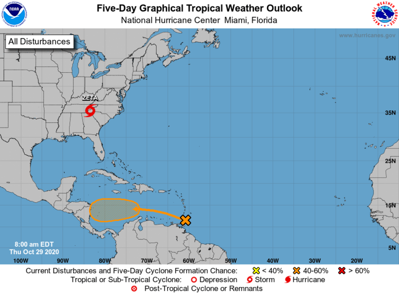
Looks like a new tropical depression has made it's debut, 60% chance of formation within 5 days =(
cozcharlie
Contributor
Started typing this before Azstinger’s post.
That system the GFS runs yesterday showed going into Nicaragua next week must be inside 5 day forecast now (was about 6 days out in GFS yesterday ). NHC has formation chance at 60 percent within 5 days. Euro is more than a day ahead of GFS from what I can tell (landfall in Nicaragua Monday afternoon/overnight). Obviously the sooner it gets over land better off we are.
Forecast still has system going into Nicaragua 500 miles from Cozumel, but I imagine there is still a non-zero chance of northward turn that could affect Cozumel. (Thankfully not in forecast, but north turns should never be completely ruled out—especially in 2020). Looks like some systems to the north of it are keeping it from turning north, so hopefully that holds.

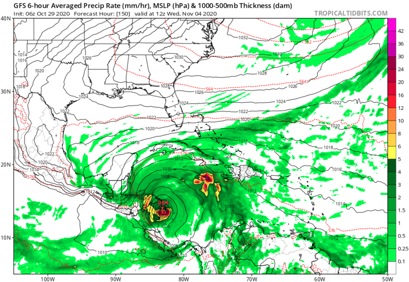
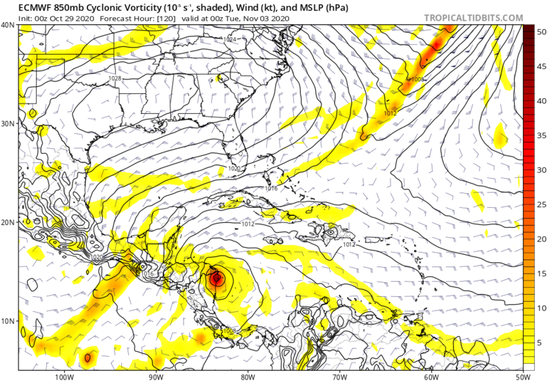
GFS has what looks like a Cat1 going into Nicaragua early next Wednesday (984 mb likely in Cat 1 range. , below 980 would likely mean Cat 2). Euro seems to show weaker system going into Nicaragua a day earlier

Euro (Monday night /Tuesday morning)

That system the GFS runs yesterday showed going into Nicaragua next week must be inside 5 day forecast now (was about 6 days out in GFS yesterday ). NHC has formation chance at 60 percent within 5 days. Euro is more than a day ahead of GFS from what I can tell (landfall in Nicaragua Monday afternoon/overnight). Obviously the sooner it gets over land better off we are.
Forecast still has system going into Nicaragua 500 miles from Cozumel, but I imagine there is still a non-zero chance of northward turn that could affect Cozumel. (Thankfully not in forecast, but north turns should never be completely ruled out—especially in 2020). Looks like some systems to the north of it are keeping it from turning north, so hopefully that holds.
GFS has what looks like a Cat1 going into Nicaragua early next Wednesday (984 mb likely in Cat 1 range. , below 980 would likely mean Cat 2). Euro seems to show weaker system going into Nicaragua a day earlier
Euro (Monday night /Tuesday morning)
nolatom
Contributor
Zeta seems to be landing as a Cat-2, TS warnings are far as Virginia, and NOAA's chief scientist was fired. Keep those paper towels stocked.
Sunny cool morning in New Orleans, no electricity or traffic lights tree branches and limbs down, but that aside it seems we got off easy. It blew hard from the East beginning about 4pm, when landfall began on the coast south of us. Felt to me like about 50 knots and gusts, but then about 6pm and just before sunset, it dropped all at once to zero. Yup, the eye was right over us. We and neighbors came out into the street and sort of marvelled at it. The sky got very orange then pink in the west, and I briefly saw a piece of blue sky high up towards North. After about 15 minutes the show was over and we went inside as the wind came back up quickly, but now from the West then Northwest, and back up to 40-50. But it didn't last all that long, and by 9pm it was pretty much done.
We lost electricity early, it's still out most everwhere. That cold front came in overnight, so it's dry and sunny for cutting up tree limbs. But almost no trees down.
I've been through a few hurricanes, some up East, some more down here. But this was a first for me, being right under the Eye. I hope others made out okay, especially the Mississippi coast just east of us, vulnerable to storm surge.
- Messages
- 54,470
- Reaction score
- 8,575
- # of dives
- 500 - 999
It looked like New Orleans was in the eye when I peeked last night. People leaving shelter to marvel at those calms is a risk with such storms as they think they're safe outside when in fact they don't really know when the eye wall will arrive and in what direction. I'm glad that you weren't hit by flying debris when it did. I wonder what happens to birds that fly around inside eyes when they get too tired to continue? I guess that they become projectiles too. PELICAN!Yup, the eye was right over us. We and neighbors came out into the street and sort of marvelled at it.
So Zeta was still a hurricane as s/he/it hit Alabama? Now a TS in Virginia...
Started typing this before Azstinger’s post.
That system the GFS runs yesterday showed going into Nicaragua next week must be inside 5 day forecast now (was about 6 days out in GFS yesterday ). NHC has formation chance at 60 percent within 5 days. Euro is more than a day ahead of GFS from what I can tell (landfall in Nicaragua Monday afternoon/overnight). Obviously the sooner it gets over land better off we are.
Forecast still has system going into Nicaragua 500 miles from Cozumel, but I imagine there is still a non-zero chance of northward turn that could affect Cozumel. (Thankfully not in forecast, but north turns should never be completely ruled out—especially in 2020). Looks like some systems to the north of it are keeping it from turning north, so hopefully that holds.
View attachment 621024
GFS has what looks like a Cat1 going into Nicaragua early next Wednesday (984 mb likely in Cat 1 range. , below 980 would likely mean Cat 2). Euro seems to show weaker system going into Nicaragua a day earlier
View attachment 621026
Euro (Monday night /Tuesday morning)
View attachment 621033
Looks like the GFS model has a pretty dead on hit Friday =(
Similar threads
- Replies
- 2
- Views
- 779
- Replies
- 9
- Views
- 1,833
- Replies
- 12
- Views
- 2,055


