Heads up for approaching Storm

Please register or login

Welcome to ScubaBoard, the world's largest scuba diving community. Registration is not required to read the forums, but we encourage you to join. Joining has its benefits and enables you to participate in the discussions.

Benefits of registering include

  • Ability to post and comment on topics and discussions.
  • A Free photo gallery to share your dive photos with the world.
  • You can make this box go away

Joining is quick and easy. Log in or Register now!

DandyDon

Umbraphile
ScubaBoard Supporter
Messages
53,886
Reaction score
8,098
Location
One kilometer high on the Texas Central Plains
# of dives
500 - 999
Invest 94 upgraded to Tropical Depression SIX - headed across southern Caribe for northern Honduras, Belize, Yucatan area for Tuesday or Wednesday. See the thread, or www.nhc.noaa.gov

023550W_sm.gif

 
Cat 5 Hurricane Felix now headed right for Belize. Good luck to all down there.

030037W_sm.gif
 
What a bummer!! I am headed to Belize on the Aggressor on the 15th, looks like the hurrican is going to make a direct hit on that area.

Well, that's the chance you take this time of year.....
 
When is the peak of the hurricane season in the Caribbean? Isn't it kind of early to have already had two category 5 storms?
 
Hurricane season runs from June 1st to Nov 30th. Aug and Sept produce some strong ones.
 
Now Cat-5

Has not changed path much. Looks like it's gonna rake the Bay Islands, Honduran northern coastal mountains - perhaps causing landslides and flooding, then plow on into Belize, with potential for picking up power again on the east side of the Yucatan.
 
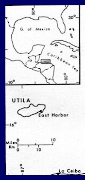
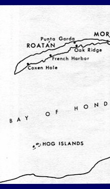
What will happen to the Bay Islands is mere conjecture until after it passes.

What is not debatable is the fate of the Corn Islands.

Much as no one in the US understood that Mitch ('98) devastated Guanaja and pounded the Bay Islands, no one has cracked open the map and noticed the small resort diving islands that are directly in the path of Felix.

The Corn Islands are very low lying (no high ground) and will be exposed to the full ferocity of Felix before it makes landfall. Also look for Half Moon Key.

On the Bay Islands in 98, Mitch caused only five islander deaths that were directly linked to the storm. 12,000+ may have died on the mainland due to mudslides, etc, mostly in the more densely settled areas. Weeks later, I saw men excavating with shovels a Toyota Hilux that was buried 17 feet down in the mud. Life goes on.

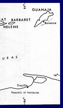
The area which Felix looks to make landfall is the Cape of Honduras (aka: Gracias de Dios) which is a low lying, swampy area inhabited by the poorest of poor. They have no idea, other than through their native abilities, that this storm is coming. Even if they did, there is little that they can do.
 
Actually, some in the US have looked at maps, but TY for the insight nonetheless. Here is the map I was viewing at the moment you posted that.

bi1.jpg
bi2.jpg
bi3.jpg


And after your post I found these...
[c]
coco_ast_2002339.jpg


Nicaragua: Corn Islands
280px-IslaMaiz.png


central_america_map1.gif

[/c]
 
DandyDon:
Actually, some in the US have looked at maps, but TY for the insight nonetheless. Here is the map I was viewing at the moment you posted that.

Don- can you find a close up map that shows those rocks a few miles to the North of Corn? Half Moon Keys, I believe. Fisherman popluation, low lying keys, interesting diving.

Dead nuts center-on for Felix.

The rocks to the South of Coxen Hole, labeled as "Hog Islands" are better known as Cayos Cochinos... dive ops, fisherman and ecological study center, just WNW of Trujillo.
 
so, what's going on in the bay islands and on the Honduran coast right now? Have all the tourists started heading home?
 

Back
Top Bottom