First time at LBTS! How to read weather/tide reports?

Please register or login

Welcome to ScubaBoard, the world's largest scuba diving community. Registration is not required to read the forums, but we encourage you to join. Joining has its benefits and enables you to participate in the discussions.

Benefits of registering include

  • Ability to post and comment on topics and discussions.
  • A Free photo gallery to share your dive photos with the world.
  • You can make this box go away

Joining is quick and easy. Log in or Register now!

dpspaceman

Contributor
Messages
136
Reaction score
14
Location
South Florida
# of dives
50 - 99
Hi all,

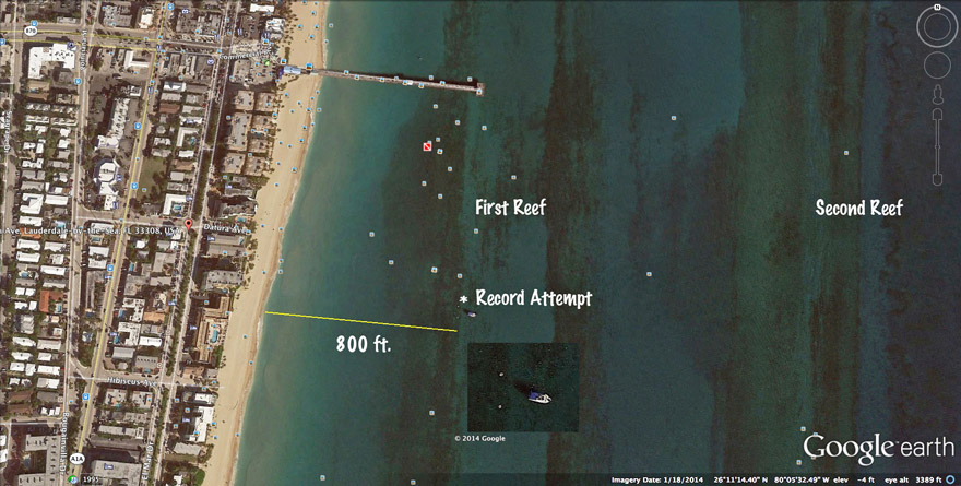
My wife and I did our first dive at LBTS this past weekend - we really enjoyed it. Went straight out from Datura to the second reef. While we loved the coral formations, felt the fish life was quite low. I was wondering if there is an area that has more or if you recommend another area?

Video below:
https://www.youtube.com/watch?v=bJJNa4UP6hg&list=UUeYZVRlT4gk_PuLnR1ZLHRA

Lucky for us the weather was perfect - and I did check the tide (went around 10-11am). I downloaded the app magicseaweed... i was wondering what the main item I would want to check prior to a beach dive would be? It would have been helpful to know the current was going North as we were constantly swimming South (though not too bad). Any tips to read weather a currents better? What should I look out for? Websites? Metrics? Etc.

Thanks!

DPS
 
It was a beautiful weekend for diving and there's not many left before it starts getting too windy and rough. I go in the early morning regardless of tides, etc. There's better parking and the wind can kick up in the afternoon. The wind had been blowing overnight, but it was from the West, which is good for beach diving. It swung around in the wee hours to the NW which creates surf and long shore current, but I knew I could still get out there in the early morning before it started to build.

You can also cheat and just check the beach cam. It's crappy now BTW. October is usually crappy and you (we) may have just gotten in the last dive of the month.

Windjammer Web Cam - Lauderdale-By-The-Sea Beach Cam

Just FYI, you were actually on the 1st reef. The second reef is much farther out where the mooring buoys are and has about 10 to 15 feet of relief in that area. It's a great dive. I know a lot of the local beach divers call that the 2nd reef, but the reef with the mooring buoys (not swim buoys) is known by everyone else as the second reef, so anything in-shore of that is 1st reef, or 1 & 1/2 reef as it's sometimes called.
 
Are you saying it's crappy because of all the coral bleaching going on? I dove the Drop Off across from 8th street(Pompano) on 8/24 and this past Sunday and what a difference in just one month, lots of red algae and bleached soft corals(zoanthids/button polyps/some stony corals too). I sure hope water temps drop soon to help with the bleaching. Vis was good but was disheartening to see all the bleaching. I read it's worse in the Keys this year.
 
I was talking about the dive conditions, though the wind has died back down now. I've been diving that area for a little over 10 years and I've definitely seen the reef deteriorate. I think it's mostly runoff from 'big sugar' production. The second reef is in much better shape. This past weekend there was a cloud of water on the surface down to about three feet that was colder and full of algae. The water underneath was about 4 degrees warmer. Very unique conditions.
 
I saw what you're talking about (the cloud of water), by where the first reef is; it looked brown/green but after I dropped down the water was clear. Wind was from the north, so I assumed it was runoff from the Hillsboro inlet moving South. Very disturbing.

How far away is the next parallel reef from the Drop Off where the markers are? I tried crossing the sand but only saw a couple patch reefs (talking about straight out of 8th Street/Pompano Beach).
 
Commerical%20Reefs%20%20s.jpg


A marked up satellite image of the area. There are a number of exposures of the first reef out to around the end of the pier. There is a relict sand filled lagoon between the first and second reef. The second reef has a few significant relief features. Usually an eastward facing ledge, sometimes with a second westward face ledge to the west of that. Then there is another sand area followed by sugar loaf-type reef morphs with large potholes, sometimes both west and east facing ledges as well (the outer second reef). The mooring balls are usually distributed along the east facing ledge of the inner second reef (about 800 yds off the beach there) and around the potholes of the outer second about 1200 yds. offshore.

Interpreting weather forecasts and tide tables for "particularly good" nearshore water visibility conditions is tricky. There are so many factors involved and they can change rapidly. Water clarity in this area is impacted by wave induced sediment loading (a function of wave height, period and duration), light from time of day, tannin stained and sediment laden water from the inlets (a function of tides and the Florida Current as well as counter-current gyres), phytoplankton blooms (a function of water temperature, the nutrified flows mentioned here, proximity/behavior of the Florida Current, upwelling, etc.), freshwater runoff from rains, turbid over-nutrified effluent from the SFWMD flood gates, even outfall plume propagation. There are still more factors. I usually look at wind predictions and for how long things have been like that. I try to go around high tide but that may not help that much always ironically enough. I look at the livecams for the area if they are available to check waves and water color, apparent clarity conditions, roll the dice and have a go. Offshore, things can become even more complicated.

Another point about the livecams, if well placed like in the case of Boynton Inlet, you can see which way the brown water outflow is predominantly going north, south or largely choked up in the inlet. This should be useful for the near term and relatively close to the inlet. I have seen it happen several times over the years where the brown water from Hillsboro migrates south and meets the brown water coming northward from Port Everglades, trashing nine miles of coast?! Nearshore currents can be complicated and good luck.
 
Last edited:
thanks for the image and info of the LBTS reef..........
 
A marked up satellite image of the area...

Nice job...

---------- Post added October 8th, 2014 at 12:12 PM ----------

The second reef is the Drop Off(or at least that's what it's called up in Pompano).

I always heard it called the Pompano Drop Off. No one seems to know that term anymore. Not sure why...
 
Commerical%20Reefs%20%20s.jpg


A marked up satellite image of the area. There are a number of exposures of the first reef out to around the end of the pier. There is a relict sand filled lagoon between the first and second reef. The second reef has a few significant relief features. Usually an eastward facing ledge, sometimes with a second westward face ledge to the west of that. Then there is another sand area followed by sugar loaf-type reef morphs with large potholes, sometimes both west and east facing ledges as well (the outer second reef). The mooring balls are usually distributed along the east facing ledge of the inner second reef (about 800 yds off the beach there) and around the potholes of the outer second about 1200 yds. offshore.

Interpreting weather forecasts and tide tables for "particularly good" nearshore water visibility conditions is tricky. There are so many factors involved and they can change rapidly. Water clarity in this area is impacted by wave induced sediment loading (a function of wave height, period and duration), light from time of day, tannin stained and sediment laden water from the inlets (a function of tides and the Florida Current as well as counter-current gyres), phytoplankton blooms (a function of water temperature, the nutrified flows mentioned hear, proximity of the Florida Current, upwelling, etc.), freshwater runoff from rains, turbid over-nutrified effluent from the SFWMD flood gates, even outfall plume propagation. There are still more factors. I usually look at wind predictions and for how long things have been like that. I try to go around high tide but they may not help that much ironically enough. I look at the livecams for the area if they are available to check wave and water color, apparent clarity conditions, roll the dice and have a go. Offshore, things can become even more complicated.


Wow this is very helpful. I remember swimming past the pier... but unsure if we went all the way to the second reef. Do folks really swim out that far? Appears to be very risky swimming out that far? All the divers were on the first reef then.... in any case i'm a novice diver.
 
https://xf2.scubaboard.com/community/forums/cave-diving.45/

Back
Top Bottom