gopbroek
Contributor
Using the Windy app animation it shows a decent formation by mid next week and then moving towards Bermuda. Of course that's a ways out but hopefully it stays in the mid Atlantic


Welcome to ScubaBoard, the world's largest scuba diving community. Registration is not required to read the forums, but we encourage you to join. Joining has its benefits and enables you to participate in the discussions.
Benefits of registering include
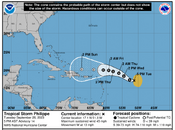
I hope so, too. The 11AM NHC update shows the predicted path bending a little more to the right/north than the earlier one this morning. That one showed it heading straight for the Caribbean and Gulf of Mexico. Of course, and as you say, it's still a long ways out.Using the Windy app animation it shows a decent formation by mid next week and then moving towards Bermuda. Of course that's a ways out but hopefully it stays in the mid Atlantic
The predicted path of Philippe has changed radically. Yesterday it was forecast to veer shaply to the right in a couple of days and spin harmlessly (to us, anyway) off into the central Atlantic.
I hope so, too. I will keep watching it, though, as I am sure you will as well.That's because it is dying, thus the storm isn't nearly as high and won't be picked up by the steering currents as was previously forecasted. It isn't expected to be much of anything. Hopefully that is the case.
I hope so, too. I will keep watching it, though, as I am sure you will as well.
Dang… that’s disappointing and a bit worrisone. We head to Cayman Friday.The predicted path of Philippe has changed radically. Yesterday it was forecast to veer shaply to the right in a couple of days and spin harmlessly (to us, anyway) off into the central Atlantic.

Those storms have been duking it out, but it looks like Philippe is going to be the winner.Looks like Phillipe changed his mind.. back to predicted north. But now Rina.. also predicted north.