The Great Travis Traverse

Please register or login

Welcome to ScubaBoard, the world's largest scuba diving community. Registration is not required to read the forums, but we encourage you to join. Joining has its benefits and enables you to participate in the discussions.

Benefits of registering include

  • Ability to post and comment on topics and discussions.
  • A Free photo gallery to share your dive photos with the world.
  • You can make this box go away

Joining is quick and easy. Log in or Register now!

Touché...you are correct, my apologies! I was thinking: of, or having an opinion. Though its expression may be construed as somewhat off-subject in this forum, you may find it odd that I am of similar opinions to yourself. I do, however, believe that this is not the correct forum for its discussion nor it's inlying pros and cons...we’re just trying to Traverse Travis here, my friend!
 
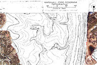
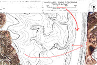
I sat in the garage and knoted up some line to add this coming weekend then survey on the way out but then I realized the existing line needs change of direction AND it is not knoted so it can not be surveyed.

I propose that my team lays in new line beside (starting beside) the existing line, knotted every 10 feet, line arrow every 100 feet and in proper direction, then surveyed, I would post the survey here in this thread.

The problem is with the bottom time it would take to do that dive and the amount of Deco my team will rack up laying in and surveying the line is quite significant so we would not be able to pull the old line out.

The next team would have to go pull the old line out, and I will not be able to make it back to Travis for almost a month after this dive.

Anyway, can't do a survey without knotted line and I figured putting in knotted line would be a lot easer than going out and putting knots on the existing line :-)

Then if anyone adds line to the new knoted line, just be sure to follow the same deal, knot every 10 feet, arrow every 100 then add survey data to existing line plot.

thoughts comments objections?
 
Hey FIXXER,

Why not leave the old line in place for now and run new line a few feet south? With the curvature of the existing line to the north, I think it would be well out of the way. The trees it's tied into should provide plenty of tie-in area, and moving the tie-in slightly south would provide a nicer/larger area for dropping stages. Also, are you planning to run the new line with new stakes at periodic intervals?

I would propose we put a new stake into the side of the riverbank as well in order to maintain the line at approximately 12-18 inches from the bottom at all times. The stake for this would greatly benefit from having a screw type base to hold it into the clay bank with plenty of tension. As for the bottom stakes, 4-6 foot PVC should provide plenty of anchorage...the existing stakes were still very much in place after a 2 year rest on the bottom. I think the suction of the gelatenous silt is holding them in quite well. The addition of screw type anchors would probably be overkill and may not hold any better due to the composition of the bottom.

We could then remove the legacy line after the traverse is complete...what do you think?

Trey
 
Alright I'll leave the old one, the new one will be white line, I'll leave a cookie at its tie off marked GTTP
 
Looking at the Topo it puts the level at 500 feet in the river channel, with current lake level that makes it over 180 feet to solid ground, that puts the silt at around 10 feet deep.
 
From the looks of this, the channel itself is a very small portion of a traverse with the opposite side being a VERY long gradual grade up to shore.

I believe the topo is from the late 30's so i'm sure there have been changes, I lined up the overlays as close as I could get them to match and beleive them to be quite accurate.

The two red dots on windy point are the locations of the first two sets of stairs.
 

Attachments

  • first shot.jpg
    first shot.jpg
    326.4 KB · Views: 149
This one is most likely more realistic with the true channel completely filled, the straight shot accross goes into what looks to be a deep valley on the other side, so if the route were to head south slightly it would avoid the valley and head closer to land, not father away.

Looks like the deep part of the channel would be ~400 feet or so, with an angled crossing to the south pushing 500 feet.

The majority of the crossing would be up the bank on the other side but that'd be a haul for sure.

Looks like a staight line crossing would be pushing 3000 feet not including the lay of the land.
 

Attachments

  • path.jpg
    path.jpg
    327.5 KB · Views: 130

Back
Top Bottom