cozcharlie
Contributor
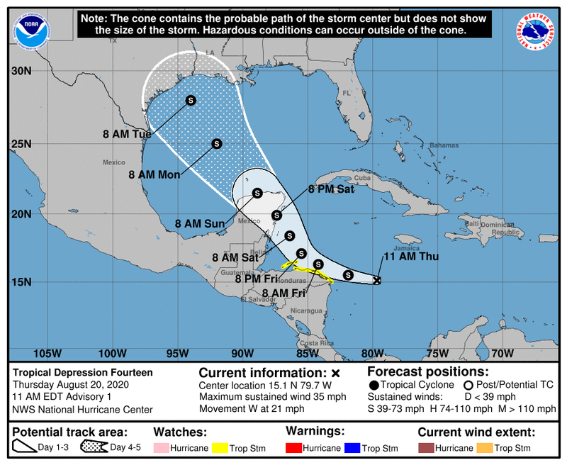
TD14 forecast to come slightly south of Coz as a strong tropical storm, with just below hurricane force winds.
If it stays at or below that forecast speed things wouldn't be too bad. The forecast winds aren't that strong and it is forecast to just move on through so duration isn't that long (unlike Wilma that went stationary for 72 hours with much stronger winds). That approach angle from the Southeast is probably reduces impacts to north part of the island (including town) since it means wind water/waves away from the West side of the island across the channel towards Playa.
If you have a Saturday flight there is a reasonable chance it gets cancelled at this point, would keep an eye out with airline. I figure most people know this, but a storm of this force shouldn't have too many lasting impacts as soon as weather clears (obviously would be wind and rain this weekend). If you have any travel plans past this weekend I wouldn't sweat it too much unless it strengths a lot beyond current forecast.

NHC wind forecast
[Tropical Depression Fourteen Forecast Discussion]
FORECAST POSITIONS AND MAX WINDS
INIT 20/1500Z 15.1N 79.7W 30 KT 35 MPH
12H 21/0000Z 15.5N 81.9W 35 KT 40 MPH
24H 21/1200Z 16.3N 84.2W 40 KT 45 MPH
36H 22/0000Z 17.1N 85.5W 50 KT 60 MPH
48H 22/1200Z 18.4N 86.4W 55 KT 65 MPH
60H 23/0000Z 19.9N 87.4W 60 KT 70 MPH
72H 23/1200Z 21.5N 88.9W 45 KT 50 MPH
96H 24/1200Z 25.0N 92.0W 50 KT 60 MPH
120H 25/1200Z 28.0N 94.0W 50 KT 60 MPH
If it stays at or below that forecast speed things wouldn't be too bad. The forecast winds aren't that strong and it is forecast to just move on through so duration isn't that long (unlike Wilma that went stationary for 72 hours with much stronger winds). That approach angle from the Southeast is probably reduces impacts to north part of the island (including town) since it means wind water/waves away from the West side of the island across the channel towards Playa.
If you have a Saturday flight there is a reasonable chance it gets cancelled at this point, would keep an eye out with airline. I figure most people know this, but a storm of this force shouldn't have too many lasting impacts as soon as weather clears (obviously would be wind and rain this weekend). If you have any travel plans past this weekend I wouldn't sweat it too much unless it strengths a lot beyond current forecast.
NHC wind forecast
[Tropical Depression Fourteen Forecast Discussion]
FORECAST POSITIONS AND MAX WINDS
INIT 20/1500Z 15.1N 79.7W 30 KT 35 MPH
12H 21/0000Z 15.5N 81.9W 35 KT 40 MPH
24H 21/1200Z 16.3N 84.2W 40 KT 45 MPH
36H 22/0000Z 17.1N 85.5W 50 KT 60 MPH
48H 22/1200Z 18.4N 86.4W 55 KT 65 MPH
60H 23/0000Z 19.9N 87.4W 60 KT 70 MPH
72H 23/1200Z 21.5N 88.9W 45 KT 50 MPH
96H 24/1200Z 25.0N 92.0W 50 KT 60 MPH
120H 25/1200Z 28.0N 94.0W 50 KT 60 MPH


