
I am going to be in the Destin area next month and am interested in diving the Destin Jetties. I am sure I can find them (jetties are hard to hide), but am interested in best place to park, where to enter, interesting sites to look for, etc. Also will have my kayak with me, is there any advantage to using the kayak to dive from. My wife does not dive, but does snorkle if conditions are right. Is snorkeling good there or is there someother place worth snorkeling in the area! Thanx in advance for any inputs made to my query!

You are using an out of date browser. It may not display this or other websites correctly.
You should upgrade or use an alternative browser.
You should upgrade or use an alternative browser.
Destin Jetties
- Thread starter bobsea43
- Start date
Please register or login

Welcome to ScubaBoard, the world's largest scuba diving community. Registration is not required to read the forums, but we encourage you to join. Joining has its benefits and enables you to participate in the discussions.
Benefits of registering include
- Ability to post and comment on topics and discussions.
- A Free photo gallery to share your dive photos with the world.
- You can make this box go away
If you have a yak you can park in the public area just to the south of 98 on the west side of the bridge. Paddle across to the east finger jetty and pull up in to the "calm" area north of the finger jetty to dive and snorkel.
I have done it only once but it is entirely possible for an experianced kayak diver to dive the Tug Louise from the state park just east of Destin. Just this trip there have been numerous kayak fisherman on that spot and I have in fact dove it solo from my Scupper Pro TW in the past. GPS coordinates are available from various places and you will need a sonar as the published coordinates are off about 100 feet. I may have the correct coordinates if your interested.
Me walking the Whaler into deeper water at the east finger jetty:

The memorial plaque on the Tug Louise:

N
I have done it only once but it is entirely possible for an experianced kayak diver to dive the Tug Louise from the state park just east of Destin. Just this trip there have been numerous kayak fisherman on that spot and I have in fact dove it solo from my Scupper Pro TW in the past. GPS coordinates are available from various places and you will need a sonar as the published coordinates are off about 100 feet. I may have the correct coordinates if your interested.
Me walking the Whaler into deeper water at the east finger jetty:
The memorial plaque on the Tug Louise:
N
SuPrBuGmAn
Contributor
You can walk(about a 1/4 mile) from the public parking available across from the trail head between the last beach house(southside) and the high rise condo's - across(soundside) from the marina. SeaYoda has a great post on location of this thread http://www.scubaboard.com/forums/florida-conch-divers/60333-insider-information-local-diving.html
Snorkeling is good there, and its a common thing to see snorkel charter boats pull in and drop 20-30 snorkelers at a time.
Snorkeling is good there, and its a common thing to see snorkel charter boats pull in and drop 20-30 snorkelers at a time.
mike_s
Contributor
I am going to be in the Destin area next month and am interested in diving the Destin Jetties. I am sure I can find them (jetties are hard to hide), but am interested in best place to park, where to enter, interesting sites to look for, etc. Also will have my kayak with me, is there any advantage to using the kayak to dive from. My wife does not dive, but does snorkle if conditions are right. Is snorkeling good there or is there someother place worth snorkeling in the area! Thanx in advance for any inputs made to my query!
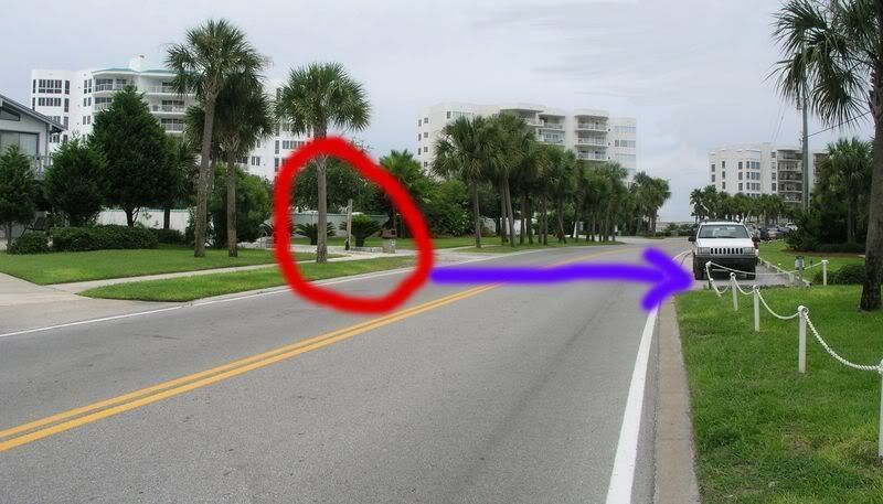
Here's a pic of where the beach access is... (with the old sign). you park across from it. (photo by Seayoda years ago).
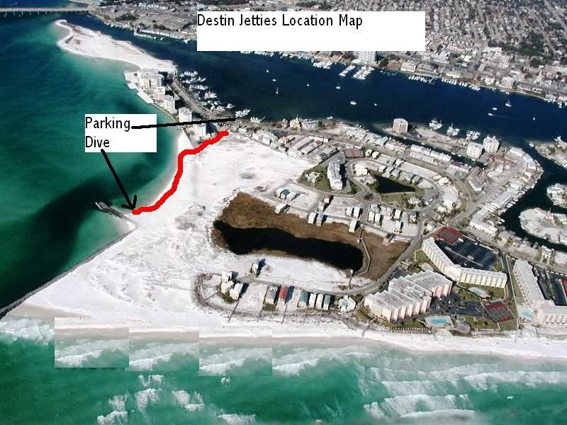
This is an overview shot of where to park, where to walk, and diving the "east finger jetty".
I have done it only once but it is entirely possible for an experianced kayak diver to dive the Tug Louise from the state park just east of Destin.
It's a lot closer paddle in your Yak to put in at the public beach accesses at Scenic 98 and Pompano Street or one of the ones a little west of there, but just not as much public parking than it is to paddle from the beach access at Henderson. just an idea.
Fox-Cousteau
Senior Member
dive the Tug Louise from the state park just east of Destin. Just this trip there have been numerous kayak fisherman on that spot and I have in fact dove it solo from my Scupper Pro TW in the past. GPS coordinates are available from various places and you will need a sonar as the published coordinates are off about 100 feet. I may have the correct coordinates if your interested.N
I'll be diving that area July 1&2, will you either post or pm the gps numbers to me? I'd like to dive that site. thanks.
The GPS coordinates for the Tug Louise per my units are:
30 22.295N
086 25.311W
The published coordinates are:
30 22.280
086 25.310W
My Navionics chart puts me right on it if I anchor on the "fish" symbol. I have three GPS and two sounders including side scan. The Whaler Nemrod may be small but I have plenty of electronic power to find even "secret" spots.
I was not recommending you dive the Louise from a kayak or that Henderson park would be the best put in, only that I have done it and that is where I put my yak in and that I found it quite do-able. Locals may have better info.
You will need a gps/sonar or at least a GPS. You will know your close when you see the endless parade of fish circling the wreck. You will also generally see other boats anchored over it either fishing or diving. Watch your weather and tides, carry a phone and a radio if possible.
Note, it is possible that my Magellon is off on the coordinates but it seems to agree with my Humminbird 900 series side scanner sonar and my Lowrance so if anyone else has better numbers for our intrepid kayaker please chime in for him. It is easy to see on sonar, it has a boomer reflection and alot of fish arches over it.

N
30 22.295N
086 25.311W
The published coordinates are:
30 22.280
086 25.310W
My Navionics chart puts me right on it if I anchor on the "fish" symbol. I have three GPS and two sounders including side scan. The Whaler Nemrod may be small but I have plenty of electronic power to find even "secret" spots.
I was not recommending you dive the Louise from a kayak or that Henderson park would be the best put in, only that I have done it and that is where I put my yak in and that I found it quite do-able. Locals may have better info.
You will need a gps/sonar or at least a GPS. You will know your close when you see the endless parade of fish circling the wreck. You will also generally see other boats anchored over it either fishing or diving. Watch your weather and tides, carry a phone and a radio if possible.
Note, it is possible that my Magellon is off on the coordinates but it seems to agree with my Humminbird 900 series side scanner sonar and my Lowrance so if anyone else has better numbers for our intrepid kayaker please chime in for him. It is easy to see on sonar, it has a boomer reflection and alot of fish arches over it.
N
mike_s
Contributor
nice pic of the fish swarming on it Nemrod.
nice pic of the fish swarming on it Nemrod.
Thanks, I could Photoshop it but factually that picture is what it looks like, the colors, the emerald green water, the slightly soupy transparency, it is accurate.
If the skies are blue and full sun and your ten plus miles offshore then the water goes blue but inshore it avctually has that green cast to it.
N
wjefferis
Contributor
How far is the tug from shore? it seems several miles out on a kayak is a bit much. But I guess everyones comfort level is different.
SuPrBuGmAn
Contributor
Its only like a mile offshore, bottom drops off a bit quicker off of Destin. The really really deep stuff is closer too, which is one reason the vis there is pretty damned good consistantly.
Similar threads
- Replies
- 11
- Views
- 242
- Replies
- 0
- Views
- 63
- Replies
- 8
- Views
- 180
- Replies
- 14
- Views
- 1,462

