Rudebob
Contributor
O.K. I have dove a few different locations at Pleasant before. However, I have come to realize that people have used the same name such as "Desert Tortoise" and "Vista Point" to mean completely different locations.
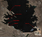
I have attached a google earth image of the south part of the lake which should include most of the popular dive site accessible by road. Perhaps some of you can chime in here so there might end up being a general consensus as to the correct site name. Feel free to copy and paste an updated image to correctly identify or name additional sites if warranted.
As far as the "Unnamed site" my OW instructor had indicated that this was Vista Point but I always thought Vista Point was on the east side of the lake (Maricopa Water District side), west around the mountain of the north launch ramp. Maybe I am wrong.
bob