hollywood rock pile yellow brick road question ?

Please register or login

Welcome to ScubaBoard, the world's largest scuba diving community. Registration is not required to read the forums, but we encourage you to join. Joining has its benefits and enables you to participate in the discussions.

Benefits of registering include

  • Ability to post and comment on topics and discussions.
  • A Free photo gallery to share your dive photos with the world.
  • You can make this box go away

Joining is quick and easy. Log in or Register now!

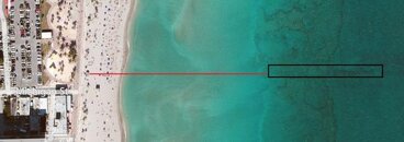
If you take the NORTH side of Michigan Street and go straight out till you are over the reef. Then go out about another 50 feet and look to the north east. You should be just about right there. Once you hit it, you cannot get lost. It runs perpendicular to shore. You can almost see it using google maps.

Ted.. yeah, yeah, whatever.... :wink:
 
I WANNA LEARN HOW TO BLOW RINGS!!! I tried "teaching myself" last week on a safety stop (yes Bilsant, that's what I was doing).

I was NOT successful.

HELP!

And I haven't hit YBR since last summer. Me thinks it is time....

Oh rings ok never mine LOL LOL

---------- Post added March 12th, 2013 at 08:02 AM ----------

If you take the NORTH side of Michigan Street and go straight out till you are over the reef. Then go out about another 50 feet and look to the north east. You should be just about right there. Once you hit it, you cannot get lost. It runs perpendicular to shore. You can almost see it using google maps.

Ted.. yeah, yeah, whatever.... :wink:
What what??? LOL
Im looking into my next dive location. I would love to do roataan again. The reef system was awsome.
 
Zombie thread!!
 
If you take the NORTH side of Michigan Street and go straight out till you are over the reef. Then go out about another 50 feet and look to the north east. You should be just about right there. Once you hit it, you cannot get lost. It runs perpendicular to shore. You can almost see it using google maps.

Ted.. yeah, yeah, whatever.... :wink:


You rock!
Maps do help lol. From the look of the maps, it appears to be inline with the lifeguard stand.
I will have to check this spot out soon.

http://oi47.tinypic.com/30t40oo.jpg

30t40oo.jpg
 
Last edited:
You rock!
Maps do help lol. From the look of the maps, it appears to be inline with the lifeguard stand.
I will have to check this spot out soon.

http://oi47.tinypic.com/30t40oo.jpg

View attachment 149840

i think i might head back there next month. But Check out Gold Coast - someone can/might suggest a meetup for that site soon. They also have a much better map on the website.

it's 574 feet direct out from the lifeguard station.then 203 feet @ 70 degrees. i think the 574 was to the buoy but Jenny said that the buoy is gone??? -- if so then i'd say straight out from the lifeguard until you hit the broken reef then swing to 70. you'll probably miss the first part but can hit that on the way back in.

parking isn't bad but can be a lug- the parking garage is right there as well as the parking lot.
 
Yeah, it's a little tricky to find. Once I actually attempted to bring my portable gps attached to my dive flag
but it was kind of heavy and tipping the flag at an angle. I have not given up though and one day will attach
the gps a bit lower on the mast then surface and mark it when I locate the beginning of the yellow brick road. I
suppose you could go out a little south from Michigan and continue a ways beyond start of reef before heading to the north.
The one time I took an angle from the old buoy I missed it and went by it to the north I believe. If I ever get the gps numbers
I will then go to google earth and locate those numbers and have a very good idea of where it starts.
 
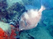
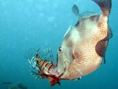
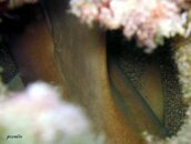
Jenny and I met for an early YBR dive this morning. Conditions were fine - there was a little surf when we first got in but nothing we couldn't manage. And Jen got us to the reef within 12 minutes. Too bad viz was so crappy (15 ft w/ lots of stirred up sand) because the reef was just alive! Huge schools of cottonwicks, french grunts and blue tang, two moray eels, a 4 ft nurse shark hiding in a hole, sailfin blenny, beautiful anemone, good sized grouper. The highlight of the dive was Jenny killing a lionfish and two triggerfish immediately snagging it. They proceeded to follow us the entire dive - by the end we had three following us.

And I'm happy to report the only thing "lost" was a huge lobster.

Thanks, Jen, for a great dive!

3 23 13 1.jpg 3 23 13 2.jpg 3 23 13 3.jpg 3 23 13 4.jpg
 
You rock!
Maps do help lol. From the look of the maps, it appears to be inline with the lifeguard stand.
I will have to check this spot out soon.

http://oi47.tinypic.com/30t40oo.jpg

View attachment 149840
Uh.. yeah... That lifeguard stand moves.. :wink:

it's 574 feet direct out from the lifeguard station.then 203 feet @ 70 degrees. i think the 574 was to the buoy but Jenny said that the buoy is gone??? -- if so then i'd say straight out from the lifeguard until you hit the broken reef then swing to 70. you'll probably miss the first part but can hit that on the way back in.

parking isn't bad but can be a lug- the parking garage is right there as well as the parking lot.

The buoy is gone. We started out a bit north, and with the north running surface current, we had to go south along the reef a little ways to hit the rockpile. My guess would be the rYBR is about half way between Michigan and Johnson Streets.
Once on the rockpile, we stayed on the north side and the area was teeming with colorful fish that even with the less than stellar vis, was especially pretty. The yellow algae was all but gone. For the lionfish hunters, when you get to the east end of the rock pile, look underneath the beginning of the YBR. There is usually a LF there, may be hiding on the underside of the bricks. A long pole spear will not work, but if you miss him, will not get him again, because they can go so far back. That is where I hit that one a couple weeks ago, and there was one there again today. I don't think it was the same one only because this one was too skittish like being hit before.
We made it about halfway out before we turned the dive, but the vis cleared up nicely the further out we went.
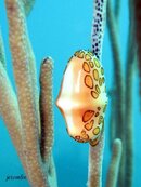
And thank you, Jet for the awesome dive! You nailed it with that flamingo tongue shot. Glad you got some decent ones with the triggerfish and LF. That was cool to watch.
 
I was told once that the vent located atop one of the street lights that run along the north side of
Michigan street was the vent for the original pipe that these bricks were sitting on top of. Sounds like
a folklore type thing but was never sure. The trick seems to be going out far enough so you know you
are at least north or south of it, then heading the appropriate direction. I made the mistake of trying a
shore dive at LBTS the other day and gotta say it will be a while before I do another shore dive with any surf at all.
Got my butt kicked on that one ! Is there any way a person could get the okay from an official agency to mark
the start of this yellow brick road with a buoy ? It really is a great little dive on a good day !
 
Last edited:
Do you really want MORE people there?
Besides, our time is limited. I fear when the Margaritaville Resort is built, despite assurances from all that we will have access, our little diving bit of paradise will be unreachable easily by shore.. I hope I am wrong.
 
https://www.shearwater.com/products/teric/
https://xf2.scubaboard.com/community/forums/cave-diving.45/

Back
Top Bottom