Underwater Geocaching?

Please register or login

Welcome to ScubaBoard, the world's largest scuba diving community. Registration is not required to read the forums, but we encourage you to join. Joining has its benefits and enables you to participate in the discussions.

Benefits of registering include

  • Ability to post and comment on topics and discussions.
  • A Free photo gallery to share your dive photos with the world.
  • You can make this box go away

Joining is quick and easy. Log in or Register now!

I know there are a few "scubacaches" in Lake Travis, Austin TX. I'm going to put out my first scubacache this spring in Greers Ferry Lake, Arkansas. My idea was to put depth markers on the cliffs of the shoreline. What ever marker the water is at will tell you how deep the cache is. Then just provide a bearing and distance on the cache page. Would have to classified as a Mystery or Multi Cache though. I'm glad other people are as into underwater caching as I am. I think it is a good idea to maybe add a geocaching forum under treasure hunting. I'm pretty new to this board, are there any rules for doing that? Thanks.
 
this is the stuff I do and I have a lot of fun doing it. The only rules are is you must be a certified diver finding the prizes. I hide them all over Arizona lakes.
 
I was under the impression that microwaves could not penetrate the water, therefore GPS's (if waterproof) could not work under water, or am I being a stoopid :dork2:.
 
:) You do not use the GPS under water. What you do is use the GPS to tell you the location and when you walk up to the water you would set up you compass the same direction the GPS tells you. If you have a GPS that can get wet you can swim on top of the water and when you are on top of the location you would put your GPS in your dive buoy and dive down and look for the prize.

set
 
The hard part about the GPS units underwater is that signal waves will reflect and bend once under the surface thus scattering and causing an inaccurate/impossible reading, this also includes differential GPS units. For geocaching scuba the way-point is the surface +/-10m depending on the sat count and p-effect of the sats, and the unit and capability of the users understandings of the settings.
I myself if I was to do this would use the GPS to go to the surface and then dive down to the depth and use my handy dandy compass and wetbook with the directions.
 
Yeah like said previously there is a website dedicated to this with the SCUBA attribute... I was quite disapointed however, we are getting into SCUBA and we have been Geocaching for the past several years and there are like 5 within 100 miles of us with the scuba atribute... of that 1 is an actual scuba cache. I am contemplating placing some however the moderator (the one that approves geocache listings) in my area is really strict of ensuring I have permission... who the heck do I ask to place a geocache without jumping through MAJOR hoops. I am thinking that is why they are not as popular. Enjoy ... if you have more questions GEOCACHING.COM has a great forum that I am sure would have more specific answers to your questions I am pretty regular on that forum as well with the same SN.
 
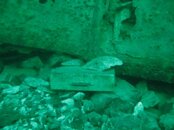
Lake Chelan Scuba Cache

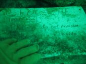
Lake Chelan Scuba Cache, CG5530, lies at about 124 feet on the west side of the lake by the side of an old car.100901 02 Lake Chelan Geo.jpg100901 04 Lake Chelan Geo.jpg

The cache has a divers white underwater slate with the few of us that have been there. There were a few things in the plastic container that they warn you to open slowly.

I'm looking for more of then to find.
 

Back
Top Bottom