- Messages
- 54,470
- Reaction score
- 8,575
- # of dives
- 500 - 999
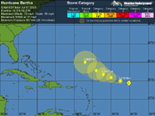
How nice, looks like she's heading more northerly afterall - and may not be even close to the Keys this weekend and may spare the Antilles and T&Cs as well....
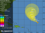
The intensity forecast
SSTs will warm quickly to 27°C by Monday morning and 28°C Tuesday morning underneath Bertha, and shear is expected to remain moderately low, in the 10-15 knot range. This should allow Bertha to intensify into a Category 1 hurricane by Tuesday. On Wednesday, Bertha is expected to hit a branch of the subtropical jet stream that will raise shear levels to 15-20 knots. The models have been steadily weakening the trough of low pressure associated with this shear in recent runs, and it now appears that the shear will not be strong enough to weaken Bertha, although it may be able to keep Bertha from intensifying further.
The track forecast
The models are now in better agreement that Bertha will track well north of the northernmost Lesser Antilles Islands, and tropical storm conditions are not likely in the islands. Bertha should continue to the west-northwest through Thursday, when a moderately strong trough of low pressure is forecast to exit the East Coast of the U.S. This trough is expected to turn Bertha to the northwest, and there is the potential for Bertha to affect Bermuda 6-8 days from now. Climatology, and the few models that we have that run out that far--the GFS and the ECMWF--suggest that this trough will be strong enough to fully recurve Bertha so that it misses the U.S. However, long range forecasts of this nature are highly erratic in their reliability, and if this trough is not strong enough to recurve Bertha, the storm may pose a risk to the U.S. East Coast 7-10 days from now.