


The goals of our project are multifold:
1. Produce a complete, registered, map of Rock Lake
2. Capture detailed hydrology information
3. Capture detailed geologic information
4. A rigorous biological survey
All results will be made available publicly.
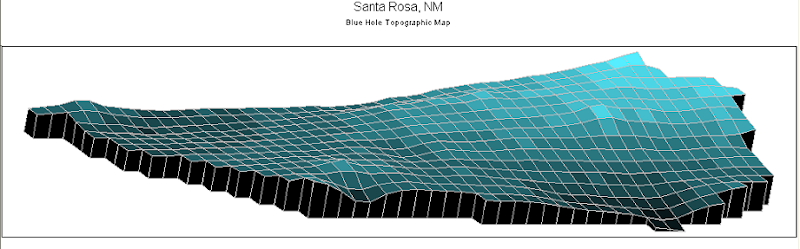
On item one, I am personally aware of two maps and have seen one of them. I will get a look at the other soon. The one that I have seen was a fine effort, but lacked the detail we hope to capture. Since we have multiple teams of extremely well trained divers, we should be able to take data at a very high rate in order to complete the map. We currently have ca. 80 data points captured and believe it will take approximately 2000 points to complete this part of the project.
On items 2&3, we have some geologic information back already from a friendly at CU Boulder and will be capturing water samples for analysis starting at the inlet vents and working upwards. Part of the goal of this particular endeavor is to discover the growth mechanism for the gypsum selenide crystal deposits found in various locations in the spring.
Item four will require some scientific guidance that we do not yet have. We are vaguely aware of some of the species inhabiting the lake, but the picture is very incomplete.
Anyone can participate with a few simple rules and possibly an in-water evaluation by me. It's a sensitive environment and we strive very hard to preserve it.
1. Produce a complete, registered, map of Rock Lake
2. Capture detailed hydrology information
3. Capture detailed geologic information
4. A rigorous biological survey
All results will be made available publicly.
On item one, I am personally aware of two maps and have seen one of them. I will get a look at the other soon. The one that I have seen was a fine effort, but lacked the detail we hope to capture. Since we have multiple teams of extremely well trained divers, we should be able to take data at a very high rate in order to complete the map. We currently have ca. 80 data points captured and believe it will take approximately 2000 points to complete this part of the project.
On items 2&3, we have some geologic information back already from a friendly at CU Boulder and will be capturing water samples for analysis starting at the inlet vents and working upwards. Part of the goal of this particular endeavor is to discover the growth mechanism for the gypsum selenide crystal deposits found in various locations in the spring.
Item four will require some scientific guidance that we do not yet have. We are vaguely aware of some of the species inhabiting the lake, but the picture is very incomplete.
Anyone can participate with a few simple rules and possibly an in-water evaluation by me. It's a sensitive environment and we strive very hard to preserve it.

")
")


