kev_328
Registered
For those interested in diving some of the lesser known sites on Lake George, feel free to use this resource.
Step1: Go Here:
http://www.adirondackscubaclub.com/googleEarth/LakeGeorge.kmz
Step 2: Save the *.kmz file to your hard drive.
Step 3: Double Click on the file that you just saved and it should open Google Earth. (You may need to associate this file with an application. I typically use Google Chrome or FireFox.)
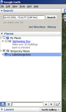
Make sure you select Lake George under the file tree for Temporary places:

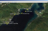
If you click on each thumb tack you should see details about the site.

Step1: Go Here:
http://www.adirondackscubaclub.com/googleEarth/LakeGeorge.kmz
Step 2: Save the *.kmz file to your hard drive.
Step 3: Double Click on the file that you just saved and it should open Google Earth. (You may need to associate this file with an application. I typically use Google Chrome or FireFox.)
Make sure you select Lake George under the file tree for Temporary places:

If you click on each thumb tack you should see details about the site.


