Johncn
Contributor
Hello,
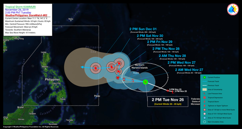
For those of us in the Philippines right now, the projected track and intensity of a new low pressure system is something keep an eye on. Current projections (which are not at a high confidence level beyond 72 hours or so) show Kammuri (PAGASA name = Tisoy) as a very strong typhoon / super typhoon impacting the Philippines next week. It has not entered the Philippine Area of Responsibility (PAR) yet, so has not made major headlines locally as yet.
Good tracking links here:
:: Typhoon2000.com® :: The Philippines' First Website on Tropical Cyclones (Since 1997)

Tropical Cyclones Worldwide
"This system has the potential, currently, to have “no limitations” on intensification, it possibly will have much slower movement on approach to the Philippines..."
I would recommend that anyone in the Philippines keep a close eye as better track and intensity information for Kammuri / Tisoy becomes available.
Here's hoping for a poleward re-curve.
Johncn
For those of us in the Philippines right now, the projected track and intensity of a new low pressure system is something keep an eye on. Current projections (which are not at a high confidence level beyond 72 hours or so) show Kammuri (PAGASA name = Tisoy) as a very strong typhoon / super typhoon impacting the Philippines next week. It has not entered the Philippine Area of Responsibility (PAR) yet, so has not made major headlines locally as yet.
Good tracking links here:
:: Typhoon2000.com® :: The Philippines' First Website on Tropical Cyclones (Since 1997)
Tropical Cyclones Worldwide
"This system has the potential, currently, to have “no limitations” on intensification, it possibly will have much slower movement on approach to the Philippines..."
I would recommend that anyone in the Philippines keep a close eye as better track and intensity information for Kammuri / Tisoy becomes available.
Here's hoping for a poleward re-curve.
Johncn


