It's Ed's Fault (really!), Discovery Bay dive report.

Please register or login

Welcome to ScubaBoard, the world's largest scuba diving community. Registration is not required to read the forums, but we encourage you to join. Joining has its benefits and enables you to participate in the discussions.

Benefits of registering include

  • Ability to post and comment on topics and discussions.
  • A Free photo gallery to share your dive photos with the world.
  • You can make this box go away

Joining is quick and easy. Log in or Register now!

g2

Contributor
Scuba Instructor
Divemaster
Messages
643
Reaction score
167
Location
Port Townsend, WA
# of dives
1000 - 2499
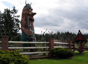
I'm not sure who Ed is or why it's his fault, but he sure does have a nice dive site. :D

Discovery Bay is sheltered from most of the current action in the nearby Straits of Wanda Fuca, making for some relaxing diving. The vis was good near the surface, 20-25ft or so, but decreased with depth.

The so-called fault is more like a ridge or small wall starting at about 40ft and descending down to 80ft or deeper. Nearby is a pinnacle that rises within 17ft of the surface at low tide -- a good place to drop anchor if you can find it. Access from shore might be possible in an ultra-low tide, but AFAIK the shoreline is entirely private property so access is only by boat. Here's a map and some other info about navigating to the site.

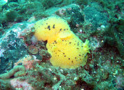
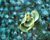
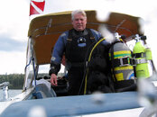
Water temp was a toe numbing 43F (6C), typical for this time of the year, with a thin thermocline teasing us near the surface. Down under are lots of rockfish, greenlings, smallish lingcod, and nudibranchs everywhere, with some odds and ends thrown in like urchins and anenomes. All good fun -- I just wish we didn't need a boat to get there (thanks Rich!). The closest launch point, at least for us non-glitterati commoners who don't own a private slip, is near the Troll Haven ranch in Gardiner. Pictures attached: copulating nudis (oh my!), snail or nudi eggs, a hero shot of Rich as Kim looks on, and two of Troll Haven.

Diving for beginners: :thumbs_up::thumbs_up::thumbs_up:
Photo ops: :camera::camera::camera:
Accessibility and ease of locating site: :shakehead:

BTW, this was dive number 500 in the log book. Woo-hoo! :yeahbaby:

glenn
 

Attachments

  • mating_nudis.JPG
    mating_nudis.JPG
    286.4 KB · Views: 134
  • nudibranch_eggs.JPG
    nudibranch_eggs.JPG
    351.9 KB · Views: 74
  • rich.JPG
    rich.JPG
    138.1 KB · Views: 71
  • trollhaven1.JPG
    trollhaven1.JPG
    158.6 KB · Views: 79
  • trollhaven2.JPG
    trollhaven2.JPG
    216.5 KB · Views: 75
Yeah, Wanda Fuca. That's the actual name of the waterway given by Royal Navy Captain John Meares in 1788 for his Inuit girlfriend Wanda. Later cartographers misinterpreted the attribution and changed it to "Juan de Fuca", thinking that he really meant the fabled Greek navigator Juan de Fuca, which is clearly wrong since Greeks don't typically have Spanish names. I aim to set the record strait [sic].

:wink:
 
Gentle readers
Long ago (read Ice Age) there was a large Ice Dam in Quilcene holding back the floodwaters of Brinnon. When this Dam broke (small version of catastrophic drainage of Pleistocene glacial Lake Missoula/Columbia Gorge), it flooded the Discovery Valley (rather large and dramatic standing wave as you will soon see) and outletted at the head of Discovery Bay, smacking into a basaltic wall we now call Protection Island.

The results of this rapid dredging project and the tailings of the flood are behind Protection Island called Dallas Bank. How cool would that be to see???!!!???

One of the obvious things when you dive Ed's Fault is how specific a flood of this nature could carve down to a basaltic fault line leaving our prime dive site. Throughout Port Townsend we have basalt walls (Tamanous Rock near Anderson Lake) popping up and breaking through the surface, Ed's Fault just needed a bit of water to help it break the surface.
Check out the erratics (big honking boulders the size of houses) at the north end of the fault and you can probably surmise how interesting it was when this 3-5 day flood carved the Discovery Valley into Discovery Bay, carrying these rocks down the Quilcene Valley and tumbling over Ed's Fault.
Try to disprove this flood theory when you can follow the river channel on NOAA maps of Discovery Bay as the flood snaked its way north until impacting the Protection Island basaltic Wall on the south side of the Island. I mean really, where in the heck did all the dirt come from to create Dallas Bank? : )

What a hoot to see that flood water shooting skyward on the south side of Protection Island, now you can see why Protection Island has such an amazing 60 degree face on that south side.
Anyway, these musings on how Discovery Bay formed allows one to see how Ed’s Fault was once a basaltic fault upwelling under a valley floor and was immovable when the flood waters hit so long ago.

For the first mention and naming of Woodman's Reef to the more appropriate Ed's Fault, check out Dave Bliss's book 'Boat dives of Puget Sound', it is first dive mentioned.
Amazing how a documented author/friend can impact NOAA charts when you tell him a tale of hydrodynamics affecting a cool dive site! He asked at lunch what I called this place-this was the local legend story I told.

BTW, you should dive the Fault when we have a plankton kill off and visability is in excess of 100 ft. Now that is weird, especially when it is a night dive (read: big wall-no current-boat dive-safe) and MANY sightings of six gills happen on Ed's Fault at night. Killer dive, dude!

Who's Ed?
My good old USAF buddy who insisted we dive the reef/fault in 1994 and the same day I lost my prized 1973 Farallon dive light in 120 ft of water off the west side of the fault.

It was your fault man, I wanted to dive the Warhawk!

2003 GSA
 
Very cool post, GSA! I'm glad you brought this thread back. My husband and I spent the morning, a couple of weeks ago, cruising Discovery Bay looking for likely dive sites. We found the wall at Ed's Fault, but we also found some other intriguing areas to investigate. We have a boat, and access to the marina at Cape George, so we're hoping to spend some time exploring up there this summer.
 
You would be amazed at what we have in the Bay.

Google Discovery Bay Trimotor (scubaboard will not let me send you the URL until I have 5 posts)
Now that is historical to have Mr. Scott resting with us in the Bay. (As the article states, Mr. Scott had been Winston Churchill's parliamentary secretary when Churchill was Minister of Munitions.) Recovery/locating of the plane is suppose to be ongoing.
Lots of erratics all over the Bay. Try searching the 40 - 70 foot ledges on the west side and you will really have fun.
 
We were looking at the sand spits on the west side -- one at the south end of the bay, and one toward the north. Each seemed to have a rather severe dropoff on one side, and I thought they'd be interesting to go investigate.

The fun thing is that, having our own boat, if we go look and there isn't anything noteworthy there, we've lost the cost of a tank of Nitrox and a couple dollars worth of gas, and we've gained the fun of going exploring.
 

Back
Top Bottom