


- Messages
- 53,669
- Reaction score
- 7,849
- # of dives
- 500 - 999
Looks like rain at least, flooding, and maybe a real storm later.....

Posted by: JeffMasters, 9:58 AM EDT on October 25, 2007
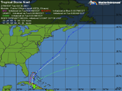
A surface low pressure system (90L) just east of Puerto Rico is moving to the west at 5-10 mph. This low is entangled with an upper-level low pressure system that is bringing about 30 knots of wind shear, so no development is likely today. Long range radar out of Puerto Rico shows bands of heavy rain hitting the islands and surrounding waters, but these bands are not well-organized. Satellite loops show most of the heavy thunderstorm activity is to the northeast of the low's center of circulation, and high wind shear is keeping this thunderstorm activity disorganized. This morning's QuikSCAT pass missed 90L.
The surface low is expected to separate from the upper level low tonight and move west-southwest or southwest across Puerto Rico, bringing the threat of heavy rain and flooding to the island. Recent rains have left large areas of interior and western Puerto Rico at or near saturation, and mudslides were reported yesterday in Utuado. Flooding problems and mudslides are likely across Puerto Rico and the Virgin Islands Friday and Saturday, and this is shaping up to be the most significant rain event of the fall wet season thus far for Puerto Rico.
On Friday and Saturday, 90L will move westward along or just south of Hispaniola, bringing heavy rain, flash flooding, and possible mudslides to that island. The ECMWF and NOGAPS models predict that wind shear will drop to 10-20 knots by Friday night, which may allow some slow development of the disturbance if the center remains over water. The GFS model keeps wind shear 20-30 knots through the period, and does not develop 90L. By Saturday, the storm will near Jamaica, and the ECMWF and NOGAPS models predict a tropical depression will form by Sunday. Steering currents grow weak on Monday, and the storm could stall out for many days in the Western Caribbean, in an area of low wind shear and high heat content waters. This may allow the system to intensify into a hurricane. The eventual fate of this system is highly uncertain, since steering currents will be so weak. Those of you planning to travel to the Western Caribbean next week should keep a close watch on this system. NHC has not scheduled any flights into 90L yet.
It is possible that wind shear and passage over the islands will sufficiently disrupt this disturbance so that it does not develop. However, surface pressures have fallen 2-3 mb over most of the Western Caribbean the past two days, and there is a good chance that a new area of disturbed weather will develop. One such disturbance formed yesterday south of Haiti, but has since dissipated. Unsettled rainy weather can be expected to affect much of the Western Caribbean over the coming week.
 Well I suppose I should take this over to the liveaboard forum, as I am starting to get off topic for this spot. I will post more later if this internet connection I found holds up. Woody