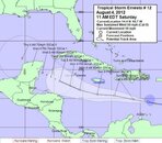
We perrennially would go to the Caymans every September, so storm watching has been a long habit for us. I just took a look through the Ernesto stuff and as of right now, I'd not be too particularly concerned about it and would assume that the Sunday flights are still going to run. mThe stats right now are saying that there's a ~20% chance of Tropical Storm winds on Monday; given that Grand Cayman will be on the north side of the storm, 7mi beach will be in the lee...might be a blustery day, but you really won't know until 7am on Monday if the boats will/won't go out. If it were me, I'd still be packing and getting ready to go.
The dilemma is that it is human nature to not be able to resist looking at the forecasts every ~6 hours between now and then, and if it takes anything of a northern slant, that will result in a closer approach. Do yourself a favor and work out the local time zone for the weather service updates, then plan to look -- just ONCE per forecast update -- at around 45 minutes after its scheduled update time. Don't lose sleep over this one.
FYI - - and all caveats apply - - it has been my unscientific "gut check" trend analysis (in the weakest sense) that tracks coming in from the ESE like this that have been further north can have their track messed up by the Blue Mountains in Jamaica. Not saying for better or worse, but just that the final track really isn't known until the center has passed by Jamaica...and given that the storms in this region often move along at a nice velocity, there isn't necessarily much time left to react (i.e., evacuate).
In any case, it looks like it is unlikely that this will make it to a CAT 2 over the Caymans, so so long as it doesn't stall out, I'd expect only one day (Monday) to really be at risk of being a blow out. The good news is that a quick-moving storm often acts like a giant vacuum cleaner, leaving great weather behind it...the best UW viz and most glassy seas I've seen in the Caymans in 24 years was two days after Hurricane Lily in 2002...and here's what the day it hit looked like on the Brac:
(during the eye of Hurricane Lily, Cayman Brac - afternoon of 30 Sept 2002)
And ~40 hours after this photo ... glassy seas with ~200ft viz off the wall.
Finally, don't be too concerned by the huge cloud cover seen on the satellite photos...there's a lot of lousy weather that surrounds a hurricane, but the actual center that has the damaging winds typically isn't all that big - - a storm that passes 150miles away is usually not a problem unless it is a monster CAT 5. You can look on the NOAA website for the "Forecast Advisory" page for a section that looks like this:
ESTIMATED MINIMUM CENTRAL PRESSURE 1003 MB
MAX SUSTAINED WINDS 45 KT WITH GUSTS TO 55 KT.
34 KT....... 90NE 60SE 0SW 50NW.
12 FT SEAS..150NE 0SE 0SW 60NW.
WINDS AND SEAS VARY GREATLY IN EACH QUADRANT. RADII IN NAUTICALMILES ARE THE LARGEST RADII EXPECTED ANYWHERE IN THAT QUADRANT.
FORECAST VALID 04/1200Z 14.2N 67.9W
MAX WIND 50 KT...GUSTS 60 KT.
50 KT... 30NE 0SE 0SW 0NW.
34 KT...100NE 60SE 20SW 60NW.
The way to read this is to envision a doughnut on a table that has a big "X" over it. The X represents the four compass quadrants in the above ... NE, SE, SW, and NW. And the numbers written by each of these directions represent the distance out from the center that the effect is present.
For example, the second block above is the forecast for August 4th at 1200 hours ZULU (i.e., Greenwich Mean Time (GMT), which would be IIRC 6AM local time in the Caymans) says that they expect the storm's center to be at 14.2N 67.9W.
Next, the 35KT line says "100NE", which means that Tropical Storm force winds (35 knots) extend out 100 nautical miles to the Northeast (and 60 miles SE, etc). However, the line above this one is "50KT ... 30NE", which means that 50 Knot winds extend out 30 miles in the same direction, which means that from the center to 30 miles is 50 knots and higher, and then from 30 - 100 miles the winds go from 49 knots down to 35 knots. Naturally, there will also be winds beyond 100mi, but these will be less than 35 knots. Ditto for when there's more wind speeds listed, ditto for when wave heights are listed.
For a storm passing south of the location you're tracking, you'll be most interested in what these forecasts are predicting for their two northern sectors (NE, NW); you can also envision this clockface bit to get an idea of what the wind direction will be on a location too...for a track to the south like this, it will probably start with winds from the NE, which will then progress (and strengthen) through ENE, then E, ESE, and then end SE ... as the storm passes by.
Hope this helps,
-hh
PS: just took another look & did a quick calculation...presently, the closest approach to Grand Cayman (19° 18' 36" N
/ 81° 15' 0" W) looks to be Tuesday's location fix prediction of 17.5N 82.0W ... which is a
calculated distance of 216.3 km = 135 miles.


c.jpg)

