CT-Rich
Contributor
I have been getting a steady stream of people asking how we make the maps tracking our dive paths. It is not particularly difficult or expensive, so I thought I would share what I have learned doing it over the past few years.
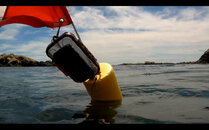
To start, we are not taking a GPS or similar device under water. GPS signals do not penetrate water. What we are using is a cell phone attached to the flag that we are towing. Here in New England, we are required to tow a flag while diving without a boat. So for pretty much all shore diving, we need to have the flag anyway.
What you will need:
A good thing to keep in mind when doing this, is the GPS is being recorded for where the float is, not where the diver is. If you are running a really long line, your location will be off by several meters. What I do if I find something of interest on the bottom and want to mark it, I will reel in the line and let it bob directly overhead for a minute. Another thing I have done to mark a spot is to swim perpendicular to our path for a couple yards and then swim back. This will leave little “X” on your path to mark your treasures.
What I find useful about tracking is the ability to compare where I thought we had gone to where we had really been. If I thought we were following a compass heading, after the dive we will know if we were right or getting pushed by a current. Some of the dives I like are kind of sprawling and comparing what I remember with where we really went can make understanding it and locating a particular spot much easier.
To start, we are not taking a GPS or similar device under water. GPS signals do not penetrate water. What we are using is a cell phone attached to the flag that we are towing. Here in New England, we are required to tow a flag while diving without a boat. So for pretty much all shore diving, we need to have the flag anyway.
What you will need:
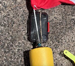
- A cell phone- I do not take my personal phone diving. I use an old decommissioned phone instead. There are two ways a phone can track your location (I am not an expert and those that are, can feel free to add in the comments). One method is to actually acquire GPS satellites and pinpointing your location. This is the best way for this activity. The second method is to triangulate the signals between multiple cell towers. Triangulation will work, but not reliably. I tried using an iPhone Mini (circa 2016) and it didn’t work well because of blind spots. Currently I am using a Samsung\ Galaxy J3 Eclipse and it works great. It is not part of a plan, so it does not work as a phone.
- A dry box- I buy the cheap polycarbonate dry boxes from Walmart. They are normally under $10. The key features to look for are that it has some sort of gasket seal, fits the intended phone and is designed to get submerged. If you tend to pull your flag under while diving, you may want something else. I have friends that use dry bags and they haven’t had any problems. I like that I can anchor the box from between the bottom of the flag and the top of the float.
- GPS tracking software. I use one called Strava, because the free version does pretty much everything I want it to do. I can turn it on, stick it in the dry box and forget about it for the duration of the dive.
A good thing to keep in mind when doing this, is the GPS is being recorded for where the float is, not where the diver is. If you are running a really long line, your location will be off by several meters. What I do if I find something of interest on the bottom and want to mark it, I will reel in the line and let it bob directly overhead for a minute. Another thing I have done to mark a spot is to swim perpendicular to our path for a couple yards and then swim back. This will leave little “X” on your path to mark your treasures.
What I find useful about tracking is the ability to compare where I thought we had gone to where we had really been. If I thought we were following a compass heading, after the dive we will know if we were right or getting pushed by a current. Some of the dives I like are kind of sprawling and comparing what I remember with where we really went can make understanding it and locating a particular spot much easier.