Dan
Contributor
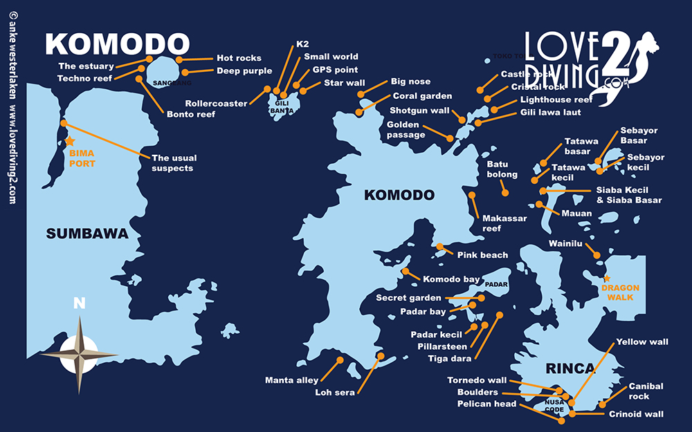
As stated in the title, if anyone has detail info any of dive sites in Bali (including Nusa Penida), Sumbawa (including Moyo, West-end of Sumbawa, Santoda, Bima, Sangeang and Banta) and Komodo, including GPS coordinates of entry location, particular time to dive it, etc., links to existing to such info, please post it here.
Background
I dove in Bali and Komodo a few times, including Bali-Komodo on Mermaid1, Indonesia Liveaboards - Mermaid Liveaboards The trips were fantastic and always want to come back. The dives would be done pretty safely and enjoyable if you go with the local guides who are familiar with the sites. However, sometimes you won't get such option and when we enter the site we would miss it and / or get blown away by the current or had to fight with the current to get to the site, instead of drifting into it. That is where this database would be useful.
Various dive resorts and dive operators describe what you expect to see underwater and how to dive it, but do not mention where you should enter the water, in terms of GPS coordinates, except @clownfishsydney website: Michael McFadyen's Scuba Diving Web Site which I think it would be a good baseline for me to start gathering those entry point GPS. Here are what I have gathered so far. Feel free to correct them as I am not the "local guide" of the sites:
Bali
Sumbawa
Komodo
Background
I dove in Bali and Komodo a few times, including Bali-Komodo on Mermaid1, Indonesia Liveaboards - Mermaid Liveaboards The trips were fantastic and always want to come back. The dives would be done pretty safely and enjoyable if you go with the local guides who are familiar with the sites. However, sometimes you won't get such option and when we enter the site we would miss it and / or get blown away by the current or had to fight with the current to get to the site, instead of drifting into it. That is where this database would be useful.
Various dive resorts and dive operators describe what you expect to see underwater and how to dive it, but do not mention where you should enter the water, in terms of GPS coordinates, except @clownfishsydney website: Michael McFadyen's Scuba Diving Web Site which I think it would be a good baseline for me to start gathering those entry point GPS. Here are what I have gathered so far. Feel free to correct them as I am not the "local guide" of the sites:
Bali
| Dive # | Site Name | GPS-DMS Coordinates | Region |
| 1 | Manta Point | 8º 47’ 55.8" S, 115º 31’ 40.0" E* | Nusa Penida |
| 3 | Crystal Bay | 8º 42’ 55.6" S, 115º 27’ 22.2" E | Nusa Penida |
| 4 | Gili Mimpang | 8º 31’ 34.4" S, 115º 34’ 32.8" E | Padangbai |
| 5 | Gili Topekong | 8º 31’ 57.4" S, 115º 35’ 03.3" E | Padangbai |
| 6 | Gili Biaha | 8º 30’ 31.3" S, 115º 36’ 52.2" E | Padangbai |
| 7 | Liberty Wreck | 8º 16’ 28.8" S, 115º 35’ 34.1" E | Padangbai |
| 8 | Drop-off | 8º 16’ 43.8" S, 115º 35’ 44.1" E | Tulamben |
| Note * | DD Coordinates | -8.798822, 115.527791 | |
| 1 minute = | 1/60 degree | ||
| 1 second = | 1/3600 degree |
Sumbawa
| Dive # | Site Name | GPS-DMS Coordinates | Region |
| 1 | Angel Reef | 8º 13’ 49.1" S, 117º 28’ 32.0" E | Moyo |
| 2 | Little Angel | 8º 13’ 50.4" S, 117º 28’ 43.4" E | Moyo |
| 3 | Satonda Reef | 8º 07’ 16.6" S, 117º 44’ 48.0" E | Satonda |
| 4 | Sumbawa Wall | 8º 08’ 52.2" S, 117º 44’ 01.1" E | W. Sumbawa |
| 5 | Sumbawa Surprise | 8º 14’ 03.1" S, 117º 41’ 40.4" E | W. Sumbawa |
| 6 | Bonto Reef | 8º 12’ 36.1" S, 118º 59’ 58.1" E | Sangeang |
| 7 | Tikno Reef | 8º 08’ 32.5" S, 119º 01’ 39.4" E | Sangeang |
| 8 | Lighthouse Reef | 8º 07’ 43.3" S, 119º 04’ 09.4" E | Sangeang |
| 9 | Hot Rocks | 8º 08’ 00.9" S, 117º 06’ 27.7" E | Sangeang |
| 10 | Rollercoaster | 8º 23’ 33.0" S, 119º 16’ 31.0" E | Gili Banta |
| 11 | K2 | 8º 24’ 12.3" S, 119º 16’ 35.8" E | Gili Banta |
Komodo
| Dive # | Site Name | GPS Coordinates | Region |
| 1 | Big Nose | 8º 25’ 40.1" S, 119º 27’ 24.2" E | N. Komodo |
| 2 | Golden Passage | 8º 28’ 30.3" S, 119º 33’ 02.4" E | Gili Lawa Darat |
| 3 | Shotgun | 8º 27’ 30.6" S, 119º 33’ 39.1" E | Gili Lawa Laut |
| 4 | Crystal Rock | 8º 26’ 32.5" S, 119º 34’ 11.7" E | Gili Lawa Laut |
| 5 | Castle Rock | 8º 25’ 50.6" S, 119º 33’ 36.5" E | Gili Lawa Laut |
| 6 | Lighthouse Reef | 8º 26’ 22.3" S, 119º 34’ 51.3" E | Gili Lawa Laut |
| 7 | Makasar Reef | 8º 32’ 06.5" S, 119º 36’ 07.7" E | Lintah Strait |
| 8 | Batu Bolong | 8º 32’ 35.5" S, 119º 36’ 58.8" E | Lintah Strait |
| 9 | Tatawa Kecil | 8º 31’ 47.4" S, 119º 37’ 41.3" E | Lintah Strait |
| 10 | Tatawa Besar | 8º 30’ 39.1" S, 119º 38’ 46.4" E | N. Lintah Strait |
| 11 | Sebayur Kecil | 8º 30’ 35.8" S, 119º 42’ 01.8" E | Sebayur |
| 12 | Wainilu | 8º 37’ 40.7" S, 119º 42’ 27.8" E | N. Rinca |
| 13 | Secret Garden | 8º 39’ 45.4" S, 119º 35’ 09.5" E | Padar |
| 14 | Padar Bay | 8º 41’ 06.8" S, 119º 34’ 00.0" E | Padar |
| 15 | Tiga Dara | 8º 41’ 10.3" S, 119º 34’ 25.3" E | Padar |
| 16 | Pillarsteen | 8º 41’ 35.8" S, 119º 34’ 13.3" E | Padar |
| 17 | Crinoid Wall | 8º 48’ 04.9" S, 119º 40’ 05.7" E | Nusa Kode |
| 18 | Yellow Wall | 8º 48’ 09.3" S, 119º 40’ 24.4" E | Nusa Kode |
| 19 | Cannibal Rock | 8º 47’ 26.3" S, 119º 40’ 18.8" E | Nusa Kode |
| 20 | Boulders | 8º 47’ 27.3" S, 119º 39’ 32.3" E | Nusa Kode |
| 21 | Torpedo Alley | 8º 46’ 34.9" S, 119º 39’ 27.3" E | Nusa Kode |
| 22 | Manta Alley | 8º 44’ 09.7" S, 119º 24' 55.8" E | S. Komodo |
| 23 | Loh Sera | 8º 44’ 37.4" S, 119º 27' 25.4" E | S. Komodo |
| 24 | Pink Beach | 8º 36' 09.1" S, 119º 31' 08.8" E | E. Komodo |


