Clear springs, springs, springs, and more springs?

Please register or login

Welcome to ScubaBoard, the world's largest scuba diving community. Registration is not required to read the forums, but we encourage you to join. Joining has its benefits and enables you to participate in the discussions.

Benefits of registering include

  • Ability to post and comment on topics and discussions.
  • A Free photo gallery to share your dive photos with the world.
  • You can make this box go away

Joining is quick and easy. Log in or Register now!

FIXXERVI6

Contributor
Messages
1,751
Reaction score
6
Location
Watauga, TX
# of dives
200 - 499
Long story short, my GPS has issues and I ended up driving all over the back country around clear springs trying to get to clear springs.

I noticed a LOT of water bodies, so I looked up google maps

This is just a snip of the area, there are lots of them, I assume these are also quarries from the looks of them, anyone know anything about the rest of the holes? do the owners of CSSP also own the little hole south west of clear springs?

I would assume diving conditions would be similiar in all locations
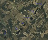
Capture.JPG
 
Hmm never knew there was so much there. Sorry I didn't get back to ya, I got your message real late after I got in from work and ended up working most of today as well.
 
I've also been interested in these water holes, but from what little checking I've done, the owners aren't interested in allowing diving. I've also heard they aren't as deep as CSSP, but everything I've heard is all second hand and not directly from the land owners.

If you find out any more info, let me know!

Kory
 
They are all quarries that were dug for the limestone to build I20. I knew about them since i had already done what you did.

Yes, the owners of clear springs also own the hole south of the park.
 
Hmm never knew there was so much there. Sorry I didn't get back to ya, I got your message real late after I got in from work and ended up working most of today as well.

Priorities are messed up
 
I actually noticed these quarries on google Earth a while back. Been meaning to go investigate; but I guess life got in the way.

Don't know about those holes....but if you have a Garmin or TomTom follow the link in my sig for a POI file of Texas Dive Sites.

POI file ?? Is that anything like a POS file? :lotsalove: Just kidding.
 
I
POI file ?? Is that anything like a POS file? :lotsalove: Just kidding.


Heh - more like a TPS report. :wink:
 
https://www.shearwater.com/products/swift/

Back
Top Bottom