Ft Lauderdale / Pompano Beach Dive Thread

Please register or login

Welcome to ScubaBoard, the world's largest scuba diving community. Registration is not required to read the forums, but we encourage you to join. Joining has its benefits and enables you to participate in the discussions.

Benefits of registering include

  • Ability to post and comment on topics and discussions.
  • A Free photo gallery to share your dive photos with the world.
  • You can make this box go away

Joining is quick and easy. Log in or Register now!

1350 dives in Boynton Beach, Palm Beach, and Jupiter. I have seen one manta while scuba diving in Boynton Beach. I have seen a few outside of the Boynton Inlet and have snorkeled with a few.
I'm pushing 1600 dives (this dive was 1586), and this is the fourth time. First time, dive 999 in June 2015. All sightings at Yellow Brick Road.
Interestingly, same day, another diver caught footage of a different manta about a half mile north
 
Anyone else ever seen a Brazilian smooth tail lobster?

 
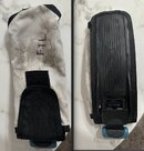
found a weight pocket today at Datura, anyone happen to know if this belongs to a local dive shop? (pic attached)

also while i'm posting, conditions were what i'd call mediocre but diveable: a bit of shore break, some mild surge and current, visibility poor near shore and gradually improved to maybe 25 feet once i got west of the end of the pier.

temp has gone up a lot recently, 84 degrees was the lowest i saw
 

Attachments

  • weight pocket.jpg
    weight pocket.jpg
    105.4 KB · Views: 9
found a weight pocket today at Datura, anyone happen to know if this belongs to a local dive shop? (pic attached)

also while i'm posting, conditions were what i'd call mediocre but diveable: a bit of shore break, some mild surge and current, visibility poor near shore and gradually improved to maybe 25 feet once i got west of the end of the pier.

temp has gone up a lot recently, 84 degrees was the lowest i saw
lowest?! how far out did you go?
 
lowest?! how far out did you go?

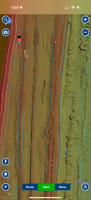
Furthest I went out is about where the red star is on the attached map.

Speaking of which, this map uses the terminology "second reef line", but I seem to get corrected every time I say that to a local :).

Can anyone tell me the proper terminology, is everything on the pic below called "the first reef line" or do people agree with the terms on this map (first reef line, second reef line)


anglin.jpg
 
Furthest I went out is about where the red star is on the attached map.

Speaking of which, this map uses the terminology "second reef line", but I seem to get corrected every time I say that to a local :).

Can anyone tell me the proper terminology, is everything on the pic below called "the first reef line" or do people agree with the terms on this map (first reef line, second reef line)


View attachment 901296

What do the locals correct it to? I am curious as that is also what I call that reef line? There is a third reef line much further out that I have swam out to but it is a long swim/dive and usually involves getting picked up by my wife, a cab or some other means of conveyance other than walking.

I just dived this area a few weeks ago. Did not swim to the third reef but had a nice dive there. Turtles possibly staging to come in to lay eggs and a good size nurse shark.
 
Furthest I went out is about where the red star is on the attached map.

Speaking of which, this map uses the terminology "second reef line", but I seem to get corrected every time I say that to a local :).

Can anyone tell me the proper terminology, is everything on the pic below called "the first reef line" or do people agree with the terms on this map (first reef line, second reef line)


View attachment 901296
You're not the only one who's slightly confused as to 1st, 2nd reef lines etc etc -

I consider the "1st" reef of LBTS 'inside' the pier and the "2nd" reef of LBTS 'outside' the pier.
Yet the 2nd LBTS reef line is considered the true '1st' reef line of most other spots it seems.

Yet from the Navionics screenshot, it looks like the inside reef line is really the 1st reefline globally, its just closest to shore near Datura and the pier. Who knows...
 

Attachments

  • IMG_8013.PNG
    IMG_8013.PNG
    565.8 KB · Views: 6
What do the locals correct it to? I am curious as that is also what I call that reef line?
some told me that what the map calls reef line 1 and 2 is all "the first reef", and that the long swim out that you mentioned is to "the second reef".

sounds like you would agree with the terms on the map though, so that's good to know.
 
some told me that what the map calls reef line 1 and 2 is all "the first reef", and that the long swim out that you mentioned is to "the second reef".

sounds like you would agree with the terms on the map though, so that's good to know.
Ah, I see. I am not a local but I have been diving down there all my life just about. But no expert. These reef lines are old sea stands resulting from global warning and sea level rise during the current Holocene interglacial period we humans have enjoyed. Well, it is a little more complicated than that involving some uplift of Late Pleistocene ---. But, yes, I guess if that is what they say. There is the 60 foot break (thrid?) and the deeper ledges variously 80 to 130 give or take. It is interesting. So is language, the 60 Foot Reef is 60 feet deep, more or less, the singular and the plural that always gets me :).
 
first reef line is in 25 -30 ft (mooring balls) a bit of a surface swim out, second is 45-60, third is 75-90.
What we dive off the beach is inside the first reef, sometimes called the rubble zone.

For purposes of shore diving there is two rubble zones pretty much along all of Broward County, that are often referred to as first and second.

Confused yet?
 
Back
Top Bottom