You are using an out of date browser. It may not display this or other websites correctly.
You should upgrade or use an alternative browser.
You should upgrade or use an alternative browser.
Ft Lauderdale / Pompano Beach Dive Thread
- Thread starter NothingClever
- Start date
Please register or login
Welcome to ScubaBoard, the world's largest scuba diving community. Registration is not required to read the forums, but we encourage you to join. Joining has its benefits and enables you to participate in the discussions.
Benefits of registering include
- Ability to post and comment on topics and discussions.
- A Free photo gallery to share your dive photos with the world.
- You can make this box go away
Jollymon32
Contributor
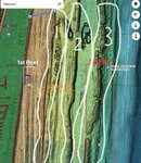
Sure, but for reference, look at the Copenhagen, it is located on the second reef line.Interesting. This is how I learned the reef lines
??
Catito
Contributor
We’ve called the red star the second reefsome told me that what the map calls reef line 1 and 2 is all "the first reef", and that the long swim out that you mentioned is to "the second reef".
sounds like you would agree with the terms on the map though, so that's good to know.
Jollymon32
Contributor
In the diagram, there is a blue line from shore to the Copenhagen wreck. The Copenhagen wreck lies on the second reef. The area you called the first reef contains the wreck of the Copenhagen, as such, your diagram is wrong.
VsubT
Contributor
Dived with Hydrotherapy out of Hillsboro inlet today on the Hydro Atlantic. Topside was a little bouncy at ~3' with occasional larger waves, but manageable. Captain John and mate Josh did a good job of dropping us south of the wreck, but the current wasn't as much as expected and it took about 5 minutes of north swimming to reach the bow. I stopped swimming to see if there was any push to the south (reversed current), and from watching the bottom there seemed to be a very light south current deeper than 100'. There was a noticeable thermocline - 82F at the surface and 70F at the bottom, with an abrupt change at 75-80' depth. Visibility was 40-50', which didn't help while looking for the wreck. Vis seemed to get a bit better once on the wreck itself.
Highlights included several large lionfish:

A school of mostly juvenile midnight parrotfish:

A good sized hogfish (estimate 22"+):

Watching the team on scooters do their thing:

And a decent sized goliath grouper hanging out off the starboard side (no pic). Total run time was 61 minutes with 28 of that on deco. Fun times.
Lance
Highlights included several large lionfish:
A school of mostly juvenile midnight parrotfish:
A good sized hogfish (estimate 22"+):
Watching the team on scooters do their thing:
And a decent sized goliath grouper hanging out off the starboard side (no pic). Total run time was 61 minutes with 28 of that on deco. Fun times.
Lance
Johnoly
Contributor
- Messages
- 4,691
- Reaction score
- 6,820
- # of dives
- 2500 - 4999
Nice Picts & Thank you for the conditions !! The upwellings this year are much earlier than the usual late July occurrences...... 82F at the surface and 70F at the bottom, with an abrupt change at 75-80' depth. Visibility was 40-50',
bassplayer
Contributor
Went for a dive today at Datura in LBTS to use up a leftover half tank.
There was enough of a shore break that some sort of surfing lessons were happening, not so rough as to make the entry or exit overly challenging though.
Water was cloudy near shore. temp 84, visibility probably 25 feet, rising as i went east. lots of people out snorkeling and diving, and I thought more fish than usual.
Highlight for me was that a spotted eagle ray came and did a couple of circles around me as i was coming in, right by the closest buoy to the costa del sol hotel.
(vertical video with not the best clarity, apologies)
Johnoly
Contributor
- Messages
- 4,691
- Reaction score
- 6,820
- # of dives
- 2500 - 4999
Nice up-close video,,,Thanks for the conditions!!Highlight for me was that a spotted eagle ray
FYI, those are creole wrasse
Similar threads
- Replies
- 1
- Views
- 1,102
- Replies
- 3
- Views
- 1,369
- Replies
- 11
- Views
- 1,948
- Replies
- 1
- Views
- 776
- Replies
- 157
- Views
- 19,441


