Yes I understand. Here's some data....
Super Typhoon Goni, the strongest storm on Earth and the strongest in all of 2020, is slamming the Philippines after making landfall at full-fledged Category 5 strength.
Super Typhoon Goni underwent rapid intensification during the week, and even strengthened slightly to feature 315 km/h sustained winds, with an astounding peak of 380 km/h.(236 miles per hour)
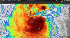
Sorry, I should have been more clear, the note about the imagery was not specific to you. It was just for anyone who sees it. Typically, when we see weather radar, the colors represent either rain (most commonly) or wind speeds.
But yes, everything you've posted so far is 100% legit. It was really surprising when Goni (Rolly) slowed her roll a few hundred km offshore... If she had kept up her pace, it would have been only Cat 3 or so when making landfall, then dropped off to severe tropical storm as it headed off the west coast.... But Nope! She slowed right down and grew... grew big time!! And, because of her sporadic pace, it's been very difficult to tell if it was going to stay more to the north or drop down to the south (as it did).
Another interesting thing about this storm is that, even as powerful as it was as it hit Caramoran and Legazpi, as it moved westward, the eye seems to have collapsed in on itself.... It's not holding its shape as one would expect a Cat 4 or 5 to do.... Goni has been a strange one, for sure!!
Anyways, a little observation report from Muntinlupa City as of 4:22pm Local (UTC+8):
Fairly light rain with moments of moderate rainfall
Winds are sustained at about 40 km/h with gusts to the mid 80's km/h (+/- 25 mph gusting to +/- 60 mph)
No signs of any damage in my area at this time. Winds are certainly enough to break small and weak tree limbs, but haven't noticed any significant breakage yet...


