Twin Lakes U/W Map?

Please register or login

Welcome to ScubaBoard, the world's largest scuba diving community. Registration is not required to read the forums, but we encourage you to join. Joining has its benefits and enables you to participate in the discussions.

Benefits of registering include

  • Ability to post and comment on topics and discussions.
  • A Free photo gallery to share your dive photos with the world.
  • You can make this box go away

Joining is quick and easy. Log in or Register now!

pcornell

Contributor
Messages
90
Reaction score
3
Location
Houston, TX
# of dives
100 - 199
Anybody have a map of whatever is in Twin Lakes?

We dove there this weekend. Nobody in our group had been in there before, so we had heard there was some stuff to see but we didn't see any of it.

I'm sure some DM candidates have mapped the lake (or at least parts of it) at some point. We are just looking for some general locations and depths to get us started.

Any help is appreciated.
 
I have never seen one. It would be nice. I dive out there often and still dont know where much other that the trailer and platforms are.
 
We found several platforms (hard to miss with big markers and down lines). Heard there is an RV, school bus and other items but the person working the gate had no idea where in the lake they were located. Big yellow Tiki head float tied to something, we followed it down to about 40' and got to zero vis and 60 degrees and decided it was not worth seeing - whatever it was. Might not have been anything other than a weight.

Saw a few nice bass hovering under the platforms. Vis for the most part was 0 to 5 feet. I guess the heavy rains earlier in the week mucked it up a bit.
 
I haven't been out there in over a year which was the only time I even went out there last year and June of 2005 I had went regularly. But the RV (old airstream trailer) was in the SW corner and the Bus was about 30 yds from the west NE corner in about 23' of water. There were a few boats just east of the road across the center near the wooden pole. One of those boats had trolling motor sticking out of the water but being a year again I don't have any idea how they have changed.

When we used to dive out there we would more or less follow the bank around about 20'-25' (about the thermocline) deep. That is were I would see the most fish.
 
I have been to the RV one time. It far end from the platforms. It was a very long swim!! I was with some people who dive there all the time and they took me to it and and back without surfacing. I think it is in the far north east corner. It was a 60min dive. No much to see, but could swim thru it.
 
:D 
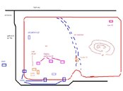
as my log book is at home in Texas, but July 04 was the last time we were there. Here's a sketch as best I recall from then. Now it's a rough sketch..... 2 minutes on paint! LOL :eyebrow: OH, edit... the RV is/ was just west of the two boats closer to the west dock, and the west dock should be a bit further north than the boats and the RV...

tony
 

Attachments

  • twin lakes.JPG
    twin lakes.JPG
    40.1 KB · Views: 79
Thanks for your effort. I appreciate it.
 
There is a speedboat suspended about where the "old platform" is marked, perhaps it replaced it as I've never seen a platform there. There is also a new dock just east of the "point" on the south side.
 
https://www.shearwater.com/products/peregrine/

Back
Top Bottom