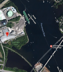
On Google Earth it shows it at only 13 feet.
You are using an out of date browser. It may not display this or other websites correctly.
You should upgrade or use an alternative browser.
You should upgrade or use an alternative browser.
Locomotive Engine 3666
- Thread starter icechip
- Start date
Please register or login
Welcome to ScubaBoard, the world's largest scuba diving community. Registration is not required to read the forums, but we encourage you to join. Joining has its benefits and enables you to participate in the discussions.
Benefits of registering include
- Ability to post and comment on topics and discussions.
- A Free photo gallery to share your dive photos with the world.
- You can make this box go away
Scuba-74
Contributor
On Google Earth it shows it at only 13 feet.
That would rule out the shore dive. There appears to be an oil terminal and a gypsum plant just to the north of it with a huge barge being pushed in by two tugs. Don't want that thing over my head when I'm at 13 feet (or even 33 feet for that matter).
Attachments
I'm interested in the source of the sonar images, if they did construction around there recently I would imagine they would have newer, better resolution ones now.
LunaBuna
Registered
If anyone verifies for sure you can use Community Edits from within the Navionics app to add a note to the chart so other Navionics users know as well. Just tap on the chart where you find the wreck, click the ? that pops up as part of the crosshairs and click Edit Map.
Similar threads
- Replies
- 41
- Views
- 3,731
- Replies
- 3
- Views
- 917
- Replies
- 3
- Views
- 836


