OP
after doing a "helicopter" view I would make a map on graph paper of what I remembered and approximately where it was. then I would make a plan for mapping it (starting point, how many tanks, etc) and start the dive. I would ensure that I had plenty of time and air for completing the project. I'd start in the morning and make a dive, taking measurements and marking my end point. then i'd come up and transfer my notes to something dry (notebook in car or graph "helo" view). Then I'd go back to my SMB that marked the end of my dive and would start again from there. Again, like all other things, the death is in the planning of the thing. 95% planning, 5% work. if you know "i'll make 4 kick cycles and measure/observe" then you should be good.
in the case of wind and swell.............. i'd do my best to guesstimate and would make the most accurate S.W.A.G (Scientific Wild Ass Guess) possible.
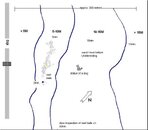
The important thing to remember is that (to me) the map is kinda like the Pirate's Code..... more of a guide than a concrete thing. it's impossible to GPS mark everything so if I could tell some one "approximately 100m past the point on this heading is the SE corner of the reef at a depth of 65 feet".
If I'm wrong in this please let me know. I'm all about learning different and better techniques.
in the case of wind and swell.............. i'd do my best to guesstimate and would make the most accurate S.W.A.G (Scientific Wild Ass Guess) possible.
The important thing to remember is that (to me) the map is kinda like the Pirate's Code..... more of a guide than a concrete thing. it's impossible to GPS mark everything so if I could tell some one "approximately 100m past the point on this heading is the SE corner of the reef at a depth of 65 feet".
If I'm wrong in this please let me know. I'm all about learning different and better techniques.