How to explore shores

Please register or login

Welcome to ScubaBoard, the world's largest scuba diving community. Registration is not required to read the forums, but we encourage you to join. Joining has its benefits and enables you to participate in the discussions.

Benefits of registering include

  • Ability to post and comment on topics and discussions.
  • A Free photo gallery to share your dive photos with the world.
  • You can make this box go away

Joining is quick and easy. Log in or Register now!

start with a compass ! Entry point/exit point.

As one suggest you could start snorkeling around and survey the place. You need a compass and a slate. Take note of headings, natural features etc..Try do draw a map of the site. Be carefull with current and boat. Once your heading are down and the map create. Go down and have fun finding out what you have survey !

My self i use wet note and a wrist slate. (and a compass of course).
 
Wow, love the detailed descriptions and information for so many dive sites in scubadoctor.com.au. I wish I had something similar for my area! It looks like tons of work and dedication to put up all that divesite database together.
 
Is there still a requirement in the PADI Divemaster course to prepare a map of the dive site?

At least there was when I took DM back in 2001.

If so, maybe you could enlist some island Divemaster candidates as "volunteers" to help with your project and also get credit for that requirement.
 
Thank you all. Great recommendations in every post. Keep them coming.

I will look for an opportunity to try this soon. I’ll keep you all posted.
 
Those of you that have read multiple dive guides, is there one you can recommend which was outstanding about the shore dives? Anywhere in the world is good.
 
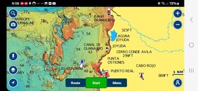
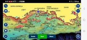
Subscribe to Navionics boating app. The shaded relief bathymetry gives you a detailed look at underwater topography.

For example:
 

Attachments

  • Screenshot_20240504_180658_Boating.jpg
    Screenshot_20240504_180658_Boating.jpg
    80.9 KB · Views: 70
  • Screenshot_20240504_180713_Boating.jpg
    Screenshot_20240504_180713_Boating.jpg
    92.1 KB · Views: 62
There was a reef guide for Cozumel created years ago through a cooperative effort between the dive shops. I wish I had a better reference to it, but it has been several years since I even visited there.

I want to remember it as being both graphic and descriptive.

Maybe someone else on here can remember it and offer better information.
 
Is there still a requirement in the PADI Divemaster course to prepare a map of the dive site?

At least there was when I took DM back in 2001.

If so, maybe you could enlist some island Divemaster candidates as "volunteers" to help with your project and also get credit for that requirement.
Yes.
 
Those of you that have read multiple dive guides, is there one you can recommend which was outstanding about the shore dives? Anywhere in the world is good.
I think the best ones that I've seen for shore diving were created by Shlomo Cohen "Red Sea diving guide"in the 1970s: way before GPS and Satellite imagery was widely available for the public. There was no internet with a trove of information readily available at one's fingertips.

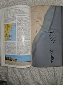
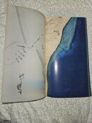
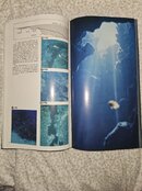
So he used aereal photos, hand drawings and transparent pages as information overlays:

"A remarkable production of a unique diver's guide to the Gulf of Akaba in the Red Sea, at time when the area was still under Israeli control. Rich in practical detail and excellent photography. With numerous appendices, covering background information. Includes full-page aerial shore photographs in color with transparent overlays superimposing current directions and other references. With numerous maps, line drawings and illustrations, color photographs."

The details included how to enter/exit the water- sometimes with photos showing the exact location. For a time that there was no internet this was like the bible for shore diving. The book was translated to several languages and he created them for several countries.

Nowadays it is much easier to do dive site description and mapping in similar way, but in a website taking advantage of GPS, combining Google earth/maps with photos from phone, drone, etc. adding layers of information and so on.

Attaching example from The Canyon at Dahab, Sinai (I found only French Edition at home).
 

Attachments

  • 20240505_064904.jpg
    20240505_064904.jpg
    103.8 KB · Views: 60
  • 20240505_064917.jpg
    20240505_064917.jpg
    89 KB · Views: 59
  • 20240505_064926.jpg
    20240505_064926.jpg
    101.1 KB · Views: 59
There was a seasoned diver, had never dived with him encircled by interested onlookers at the dive shop
with him drawing an underwater map of a site in an area of hundreds so I recognised it and told them so

A guy drawing an underwater map on the counter on a paper scrap, and I recognised it, I was impressed

See so all you need is some seasoning


It's also quite inspiring having a chat with Howard Rosenstein

It was SO much easier when we had to think to survive, rather than surrendering our thinking to survive


It only happens, when you make it, so
 

Back
Top Bottom