- Messages
- 54,118
- Reaction score
- 8,269
- # of dives
- 500 - 999
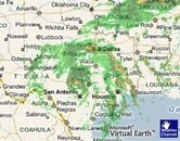
Looks like he might break up over my part of Texas! :shocked2:

Posted by: JeffMasters, 9:47 PM GMT on September 06, 2010 Wunder Blog : Weather Underground
Steadily intensifying Tropical Storm Hermine is closing in on the coast near the Texas/Mexico border, and should move ashore late tonight. Hermine became a tropical depression at 11pm last night, and could become a minimal hurricane by 11 pm tonight. Hermine's rate of intensification from nothing to a strong tropical storm is one of the fastest on record. It turns out that the extreme southwestern Gulf of Mexico's Bay of Campeche, where Hermine formed, is prone to these sort of rapidly intensifying tropical storms. The curvature and topography of the land help induce a counter-clockwise spin to the air over the region, which helps get tropical storms spinning up unusually quickly. Helping the spin-up process are the very warm 30°C waters, low 5 - 10 knots of wind shear, and moist atmosphere. Hermine promises to be a very wet storm, and latest long range radar out of Brownsville, Texas shows a large area of heavy rain has been drenching southern Texas and northern Mexico all afternoon, with radar estimated rainfall amounts exceeding two inches in a few areas along the coast. Radar loops show that an eyewall is attempting to form, but a region of dry air from over land spiraled into Hermine's core between 4 - 5pm EDT, disrupting eyewall formation. However, it now appears that Hermine has closed off its eye from this dry air, which should aid in intensification. Satellite imagery shows Hermine has vigorous thunderstorms with very cold tops, and improving low-level spiral banding.
Forecast for Hermine
Hermine doesn't have much time over water before it comes ashore, which is a good thing. The storm is steadily organizing, and has a shot at reaching hurricane strength before the center moves ashore late tonight, near midnight. Heavy rain will be the main threat from Hermine, though isolated tornadoes may also cause damage, particularly over South Texas. Hermine is expected to accelerate through Central Texas Tuesday and Wednesday, and the storm's rains will help alleviate moderate to severe drought conditions affecting Central Texas.


