Cape Cod "Airplane Wreck"

Please register or login

Welcome to ScubaBoard, the world's largest scuba diving community. Registration is not required to read the forums, but we encourage you to join. Joining has its benefits and enables you to participate in the discussions.

Benefits of registering include

  • Ability to post and comment on topics and discussions.
  • A Free photo gallery to share your dive photos with the world.
  • You can make this box go away

Joining is quick and easy. Log in or Register now!

Garbage Beach in Woods Hole has been a favorite dive for many of us every fall. We like to go on a Sunday morning in October or November when we can secure parking and there is low boat traffic. Many old bottles (have found some as early as 1862) and nice sealife can be found.

However what we have understood is the site of Garbage Beach is to the west of that shown in the previous post. I've attached a version of the same map indicating what we have been diving as Garbage Beach. We go out along the jetty and sqaure around clockwise for a nice 45 min - 1 hr 50' dive with comfortable temps and conditions.
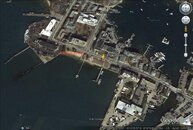

garb.jpg
 
That's Eel pond at the top of the picture - no diving there. The lower left is the WHOI dock area. If Atlantis is out it MIGHT be diveable but the authorities wouldn't look too kindly on it if they catch you.

The building just above the WHOI docks is where we worked on the first ship-to-shore batch data transfer system, allowing researchers to use the shore side WWW from their research vessels, albeit with a 12-hour batching delay.

Off the bottom of the pic you're into Great Harbor. I've seen currents of 11 knots there in a flood, and there are plenty of rocks to smash you up as the current bashes you into them. Good drift striper fishing when you're on lunch break from the MBL though. :)

Some good memories there. Thanks for posting the pic. :)

-Adrian
The WHOI docks are at the bottom of the picture, what I would call lower right, not lower left. The docks on the left are those of NOAA NMFS.

When I took the science-diving course at WHOI one of our tasks was to do a compass run across Eel Pond. Zero viz, metal everywhere. Nobody was successful. I think it was the only time that skill was attempted in that location!
 
I know this is an old thread, but does anybody have any info on the "airplane wreck"? Gonna be spending a week on the cape in August and will have my boat along to do some dives... this one sounded pretty interesting.

Thanks in advance,
Austin
 
I know this is an old thread, but does anybody have any info on the "airplane wreck"? Gonna be spending a week on the cape in August and will have my boat along to do some dives... this one sounded pretty interesting.

Thanks in advance,
Austin

Maybe you should try offering to take the diver that tells you the location on the dive with you, sweeten the deal a little. Don't forget your shark cage, Large Marge is out and about at the cape.
 

Back
Top Bottom