- Messages
- 54,481
- Reaction score
- 8,580
- # of dives
- 500 - 999


Welcome to ScubaBoard, the world's largest scuba diving community. Registration is not required to read the forums, but we encourage you to join. Joining has its benefits and enables you to participate in the discussions.
Benefits of registering include
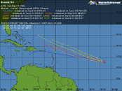
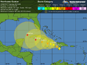
A large but disorganized area of disturbed weather centered about
350 miles east of the Windward Islands is moving to the west-
northwest at 15 mph. Any development of this system should be slow
to occur during the next couple of days. Regardless of
development...locally heavy rains and gusty winds are expected to
overspread portions of the leeward and windward tonight and
continue into tomorrow.
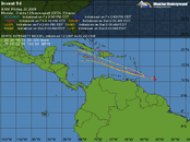
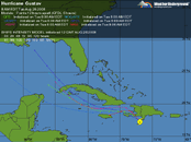
Satellite and surface observations indicate that the low pressure
area located over the central Caribbean about 250 miles south of
Santo Domingo continues to show signs of organization. Upper-level
winds are favorable for additional development...and the system
could become a tropical depression at any time today or tonight.
Watches and/or warnings may be required for portions of Hispaniola
later today. Interests in Jamaica...eastern Cuba...and the
southeastern Bahamas should monitor the progress of the low as it
moves northwestward at 10 to 15 mph. An Air Force Reserve unit
reconnaissance aircraft is scheduled to investigate the system
later today.
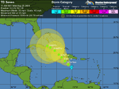
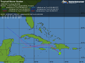
The National Hurricane Center is issuing advisories on Tropical
Storm Gustav...located about 130 miles south-southeast of Port-au-
Prince Haiti...and the Hydrometeorological Prediction Center is
issuing public advisories on Tropical Depression Fay...located over
east-central Mississippi.
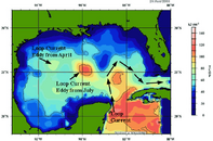
His discussion on that page is fascinating. Interesting that the Texas Gulf could not only harbor an eddy from July but even a remnant from April - attached. He noted that the hills of Haiti had weaken Gustav, but you're right - if he finds that eddy, he could energize. Hehe, his prediction discussion is almost humorous - emphasis mine...The wunderblog discussion here:
Wunder Blog : Weather Underground
Points out that the tracks aren't really known well, might hit the yucutan, yucutan channel or cuba... but if it heads through the yucutan channel there's a loop current eddy from july that it could pick up a lot of intensity from. That could spin it up into a category 5
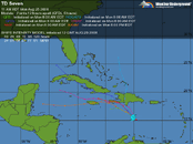
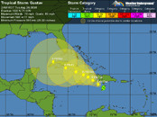
The track forecast for Gustav
The latest 12Z (8 am EDT) model runs continue to be in good agreement on the 1-3 day track of Gustav, and we can be confident that Gustav will turn west and pass south of Cuba after leaving Haiti. The trough of low pressure currently exiting the U.S. East Coast and pulling Gustav northwest is expected to move off to the east, allowing a ridge of high pressure to build in and force Gustav due west or slightly south of due west. After three days, there is more divergence in the models. The NOGAPS model no longer foresees landfall on Mexico's Yucatan, and now takes Gustav to a final landfall in the Florida Panhandle on Monday. The ECMWF is now the only model predicting a landfall in the Yucatan. This model predicts a second landfall in Texas. The GFDL is a little slower than its previous run, but still forecasts a Category 3/4 hurricane hitting Louisiana on Sunday evening. The UKMET prefers a Texas landfall. The GFS is not much help--it dissipates Gustav.